
 Live Science Plus


Alberta Clippers to Bring Cold, Some Snow to North
This article was provided by AccuWeather.com.
A persistent plunge of cold air will bring with it additional rounds of light snow and heavier lake-effect through the first week of February from the northern Plains into the Midwest, mid-Atlantic and New England.
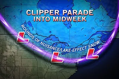
The weather pattern will favor near- to slightly below-average temperatures and multiple weak, fast-moving storms originating from western Canada, called Alberta Clippers. As many as a half a dozen of these systems may swing through over the next week.

One or more of these systems will affect the cities of Minneapolis, Chicago, Indianapolis, Cincinnati, Pittsburgh, Washington, D.C., Baltimore, Philadelphia, New York City and Boston.
Temperatures will stop well short of record low levels into next week. However, the clippers will stir up the wind at times. The wind and other atmospheric conditions will add to the feel of the cold, knocking 10, 20 and even 30 degrees off of the actual temperature at times.
Generally, these weak storms produce light and spotty snow that is easy to shovel or sweep away (a coating to a couple of inches). Occasionally the storms can be a bit stronger and can grab extra moisture, producing narrow bands of moderate snow (3 to 6 inches). This tends to happen near the Great Lakes and can be squeezed out over the mountains. Once in a while, the storms can do this along the immediate Atlantic coast.
One such clipper grabbed extra moisture in part of the Delmarva Peninsula and the Jersey Cape Friday morning. Another could achieve this in parts of coastal New England on Sunday. Cape Cod is most likely to experience this with the next clipper.
Get the world’s most fascinating discoveries delivered straight to your inbox.

In between the clippers, there will be shifting bands of lake-effect snow. The bands of snow will act like giant versions of snow guns seen at some ski resorts. Where these bands of snow persist, some communities will pick up a few feet of snow over the next week in the pattern.
Occasionally, the lake-effect snow and snow squalls can form well away from the lakes, when very cold air moves in aloft. This setup occurred during Thursday and could happen again Saturday night into Sunday from the Midwest to the Appalachians.

For folks immediately downwind of the Great Lakes this is fairly routine in a lake-effect event. However, brief, spotty whiteout conditions can occur well away from the lakes as well in such a setup.
For some locations from the northern Plains to the interior Northeast, the pattern favors snow in the air much of the time over the next week as winter bottoms out.
AccuWeather.com. All rights reserved. More from AccuWeather.com.
With much of the country experiencing an unseasonably warm winter, fears of climate change come to mind. See how well you understand recent weather, climate and the difference between them.
Weather vs. Climate Change: Test Yourself
