It's quick and easy to access Live Science Plus, simply enter your email below. We'll send you a confirmation and sign you up for our daily newsletter, keeping you up to date with the latest science news.
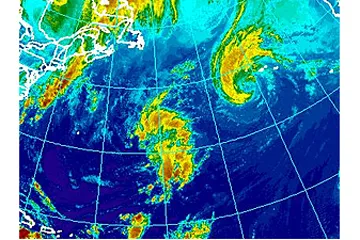
Nadine appears as the swirl of clouds in the upper-right portion of this National Oceanic and Atmospheric Administration satellite photo taken Sept. 19, 2012.
Nadine will continue to drift over the Central Atlantic Ocean and will bring unsettled conditions to the Azores through at least the end of the week.
According to Expert Senior Meteorologist Dan Kottlowski, head of AccuWeather.com's Hurricane Center, "Nadine will slow down and wobble around west and southwest of the Azores through the end of the week."
In this position, the system, which has become somewhat unwrapped in recent days, can bring episodes of squalls to the islands and ongoing rough seas and surf.
According to Senior Meteorologist Rob Miller, "A significant amount of dry air has been drawn into the storm, so there will be periods where the sun will be out over the islands."
During the squalls, however, winds will kick up to tropical storm force, and the downpours can be locally heavy and disruptive to outdoor activities.
"There is a possibility that Nadine will lose tropical characteristics over the next few days," Kottlowski stated.
Sign up for the Live Science daily newsletter now
Get the world’s most fascinating discoveries delivered straight to your inbox.
Regardless of classification, the overall rounds of unsettled weather in the Azores would continue until the storm moves away or completely breaks up.
Meanwhile, an area of low pressure west of Nadine has a small window of opportunity to develop tropical characteristics. The system Wednesday was a little less than 700 miles east of Bermuda.
"This system is currently over warm water and has a chance to develop through the end of the week," Kottlowski said, "Beyond that, the system will venture into cooler water."
As a result, Bermuda is likely to experience a few showers and a breeze from the large system, regardless of classification Friday into Saturday.
Meanwhile, much of eastern North America will be protected by strong westerly winds into next week.
(Image credit: AccuWeather.com)
"The only potential vulnerable areas during this time would be part of Atlantic Canada, the Caribbean and Central America," Kottlowski stated.

 Live Science Plus