 Live Science Plus


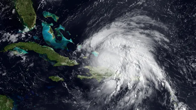
Hurricane Irene Affirms 'Magic' Hurricane Date
Hurricane watchers circle Aug. 20 on their calendars every year. This is the "magic" date when hurricane season seems to kick into high gear.
Like clockwork, Hurricane Irene — the Atlantic's first hurricane of 2011 — was born on Aug. 22, later strengthening to a Category 2 hurricane. Last year was another good example of an active storm season ramping up after Aug. 20. All of the 2010's major hurricanes (those of Category 3 or higher) formed after Aug. 20, starting with Danielle on Aug. 21.
Article continues below"Now, storms can get going before Aug. 20, but this is typically about when they start," said Phil Klotzbach, a hurricane forecaster at Colorado State University in Fort Collins.
This year was typical in saving its biggest storm so far for after Aug. 20, but it was unprecedented in the number of tropical storms that fizzled before reaching hurricane strength. The 2011 hurricane season began with eight tropical storms that all failed to become hurricanes before Irene broke the streak. One reason for the flurry of tropical storms is that scientists are naming more tropical storms than in past years, Klotzbach said.
The last time a hurricane season saw so many tropical storms before seeing a hurricane was 2002. That year, Tropical Storm Gustav eventually broke the string by strengthening to a Category 4 hurricane. Gustav struck Louisiana on Sept. 8, killing 112 people.
The hurricane forecast from the U.S. National Oceanic and Atmospheric Administration (NOAA) calls for 14 to 19 named storms (which include tropical storms and hurricanes), seven to 10 hurricanes and three to five major hurricanes (Category 3 or higher).
Irene is currently a Category 2 storm, with winds of up to 100 mph (160 kph), and is the first serious threat to the U.S. coast in three years. If no hurricanes make landfall in 2011, this three-season lull will be the longest in recorded history.
- History of Destruction: 8 Great Hurricanes
- In the Eye of the Storm: NASA's Hurricane Hunters
- Natural Disasters: Top 10 U.S. Threats
Email OurAmazingPlanet staff writer Brett Israel at bisrael@techmedianetwork.com. Follow him on Twitter @btisrael.
