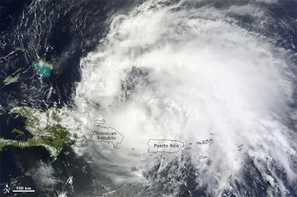
Hurricane Irene, the first hurricane of the 2011 Atlantic hurricane season, was seen from space today (Aug. 22) as it roared past Puerto Rico.
Irene formed as a tropical storm east of the Leeward Islands on Aug. 20. By early Aug. 22, the storm had strengthened to a Category 1 hurricane. The U.S. National Hurricane Center (NHC) reported that Irene had maximum sustained winds of 80 mph (130 kph), with higher gusts. The storm was located about 150 miles (240 kilometers) west-northwest of San Juan, Puerto Rico.
The Moderate Resolution Imaging Spectroradiometer (MODIS) on NASA's Terra satellite captured this natural-color image at 11:20 a.m. local time (15:20 UTC) on Aug. 22. Storm clouds cover part of the Dominican Republic, and all of Puerto Rico.
As of Aug. 22, Irene had cut power to more than a million residents of Puerto Rico, according to ABC News. The Miami Herald reported that heavy rains had pushed at least five rivers over their banks on the island. Citing continuing rains, downed power lines, and potential landslides, the Puerto Rico governor urged residents to stay indoors.
Moving westward to the island of Hispaniola, Irene menaced the Dominican Republic and Haiti. The storm's worst winds and rains remained north of the island, reducing the threat of deadly flooding, according to news reports. Nevertheless, authorities worried about approximately 600,000 Haitians still living in Port Au Prince tent cities after the 2010 earthquake.
(Image credit: NASA.)
The NHC reported that a hurricane warning was in effect for the north coast of the Dominican Republic, the southeastern Bahamas, and the Turks and Caicos Islands. A hurricane watch was in effect for the north coast of Haiti. Irene was moving toward the west-northwest at roughly 12 mph (19 kph), and was expected to continue in that direction for the next day or two.
Five-day projections released by the NHC on Aug. 22 showed Irene heading for the continental United States, potentially making landfall in Florida, Georgia or the Carolinas.
Sign up for the Live Science daily newsletter now
Get the world’s most fascinating discoveries delivered straight to your inbox.
Irene is the first hurricane for what has been forecast to be an active season. The National Oceanic and Atmospheric Administration (NOAA) updated its forecast on Aug. 4, predicting 14 to 19 named storms (which include tropical storms and hurricanes), seven to 10 hurricanes and three to five major hurricanes (Category 3 or higher). An average Atlantic hurricane season will see 11 named storms, six hurricanes and two major hurricanes. August through October are the peak months of the Atlantic hurricane season.
For the science geek in everyone, Live Science offers a fascinating window into the natural and technological world, delivering comprehensive and compelling news and analysis on everything from dinosaur discoveries, archaeological finds and amazing animals to health, innovation and wearable technology. We aim to empower and inspire our readers with the tools needed to understand the world and appreciate its everyday awe.