
 Live Science Plus


Pinatubo: Why the Biggest Volcanic Eruption Wasn't the Deadliest

If you'd been on the Philippines island of Luzon on June 15, 1991, you'd have been forgiven for thinking that the world was ending.
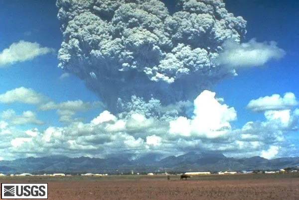
Typhoon Yunya was screaming across the island, but the angry skies were nothing compared with the angry Earth. Mount Pinatubo, an unassuming volcano that no one had even realized was active until a few years prior, was blowing its top. A column of ash spewed 21 miles (34 kilometers) into the atmosphere, opening like an umbrella to form a cloud 249 miles (400 km) across.
On the way back down, Pinatubo's ash mixed with Yunya's rain, creating a concretelike mud that collapsed roofs more than 9 miles (15 km) away. The streets were choked with evacuees, including the scientists in charge of monitoring the volcano, who were reduced to rinsing their ash-streaked windshield with a six-pack of cherry soda.

The eruption of Mount Pinatubo was the second-largest volcanic cataclysm of the 20th century, second only to a 1912 eruption on the sparsely populated Alaskan Peninsula. Mount Pinatubo, on the other hand, threatened tens of thousands who lived on or near its slopes. [In Photos: The Colossal Eruption of Mount Pinatubo]
Nonetheless, only a few hundred people died in the initial eruption, thanks to round-the-clock volcano monitoring, proactive evacuation plans, and a little bit of luck. It was a success that helped cement the importance of close volcano-watching — though scientists are still searching for the unique clues that might warn them that an eruption will be as large as Pinatubo's.
A giant awakens
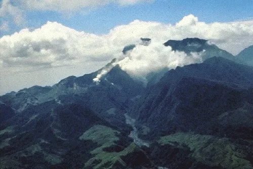
The first sign that Pinatubo might be restless came in mid-March 1991. Frequent earthquakes shook the area, alarming residents. On April 2, an explosion opened a line of steaming vents along the mountain.
The Philippine Institute of Volcanology and Seismology (PHIVOLCS) rushed to the scene, bearing five seismic monitors. They also called in the United States Geologic Survey's (USGS) Volcano Disaster Assistance Program, a group formed five years earlier to help with volcanic emergencies around the globe.
Pinatubo had not emitted so much as a volcanic burp in living memory, but a look at the area's geology revealed that the mountain could produce very large eruptions, said USGS team leader Chris Newhall, now the volcano group leader at the Earth Observatory of Singapore.
"But we didn't know whether it WOULD erupt, or whether an eruption would be LARGE," Newhall wrote in an email to LiveScience. "So you can't recommend an evacuation right away."
Instead, the team gathered every bit of information they could about the mountain. They deployed additional seismometers, walked around looking at ancient volcanic deposits and flew helicopter missions close to the volcano to see what was going on.
"We're kind of coming into a volcano that no one knew much about," said John Ewert, now the scientist-in-charge at the USGS Cascades Volcano Observatory. "There had been no monitoring, no baseline has been collected. No geologic map, no hazards map, nothing. … There was an element of building the boat and rowing it at the same time."
Buildup to a blowout
On top of the scientific challenge, there was also a massive amount of personal pressure. About 500,000 people lived near Pinatubo, and convincing them that this unassuming, jungle-covered lump was a threat was no small feat. In addition, Clark Airbase, the U.S. facility that became the scientists' command center and home away from home, sat about 9 miles (15 km) from Pinatubo, and a base evacuation was not to be taken lightly.
In other words, if the scientists were going to urge an evacuation, the volcano had darn well better blow. [10 Biggest Volcanic Eruptions in History]
As May turned into June, the volcano continued rumbling and emitting streams of ash. By the morning of June 8, a lava dome appeared on the peak. This was a sign that hot magma was pushing up against the surface, stretching and bulging the land above. By June 9, officials had ordered 25,000 people out of the area. On June 10, American officials made the call to evacuate more than 14,000 service members and their families from Clark Airbase.
The suddenly empty airbase was just one more source of pressure for the scientists, who took the opportunity to move their base of operations to the side of the base farthest from the steaming volcano. USGS volcanologist Richard Hoblitt, now at Cascades Volcano Observatory, described the anxiety wryly.
"If the volcano had not performed, it wouldn't have been very good for our careers, let's put it that way," Hoblitt told LiveScience.
Ka-boom
They wouldn't have to wait long. At 8:51 a.m. local time on June 12, the seismometers on the mountain's slopes went haywire as the volcano sent a column of ash and steam 11 miles (19 km) into the air at the speed of an F-15 jet.
As Hoblitt and Ewert watched the volcano blow, they felt relief. Their admonitions — and the evacuation of more than 60,000 people — had not been in vain. But the relief was followed by concern, as after the initial 40-minute eruption, Pinatubo started rumbling again. The volcano was just getting warmed up.
Over the next three days, the volcano spit out three more vertical eruptions and 13 smaller eruptions that produced pyroclastic flows(molten mixtures of ash, gas and rock that can sweep over the landscape at more than 60 miles (100 km) per hour).
And then, on June 15, Pinatubo really let loose. Sometime around 1:42 p.m., the stop-and-go eruptions turned into one long, roaring explosion. Chunks of pumice the size of golf balls fell at Clark Airbase. Ash spewed higher than it ever had before, and lahars, or mudflows, rushed down the slopes in a clatter of banging boulders.
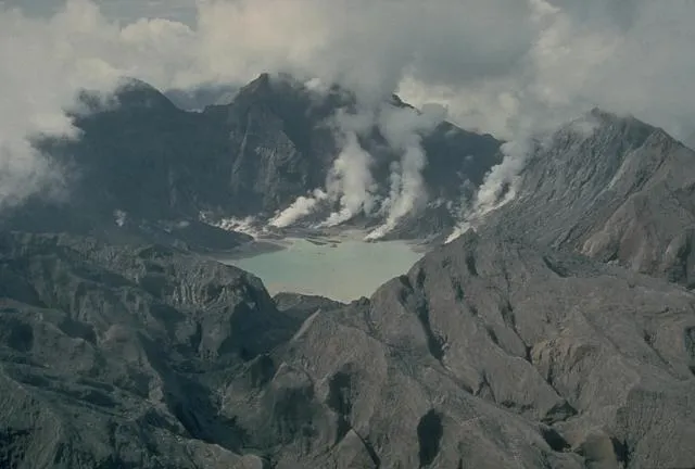
With all of their seismometers swallowed by the volcano's pyroclastic flows, Hoblitt, Ewert and their colleagues evacuated Clark Airbase as Typhoon Yunya dumped rain overhead. Rain-soaked ash streaked their truck's windshield, Hoblitt said, so the scientists wiped it clean with cherry soda, the only beverage left in the airbase commissary that no one wanted to drink. They rode out the night 24 miles (38 km) away at an agricultural college, feeling the earth quake as Pinatubo's summit collapsed into a 1.5-mile (2.5 km) caldera.
The Aftermath
By the time Pinatubo's climactic eruption ended, a snowlike blanket of ash at least a half-inch (1 centimeter) thick coated 4,660 square miles (7,500 square km) of the island of Luzon. Over the next year, the ash spewed into the atmosphere by Pinatubo would lower global temperatures by an average of 0.9 degrees Fahrenheit (0.5 degrees Celsius). The volcano would continue smoldering and smoking for months. And for years afterward, monsoon season would wash ash down the mountain's slopes in devastating lahars, raising the initial death toll of the eruption from 200 or 300 to more than 700.

But for as large as Pinatubo's eruption was, the death toll was remarkably small. At least 20,000 lives were saved. Aggressive monitoring and public information campaigns did their job, PHIVOLCS director Raymundo S. Punongbayan wrote in "Fire and Mud," a USGS collection of papers about Pinatubo's eruption.
But a big part of the Pinatubo evacuation's success is owed to the volcano's timing, Hoblitt said.
"The fact is that the pace of the activity was just about right for people to react to it," he said. "There was a steady escalation and that escalated up and culminated in an eruption."
Many eruptions are much more strung out, he said, which makes people impatient and unlikely to listen to warnings that the big one is coming.
Pinatubo is not expected to erupt again for hundreds of years, assuming it keeps to its usual schedule. But if the mountain did blow today, Ewert said, monitoring it would be slightly easier, thanks to 20 years of technological advances. Today, the Internet makes it easier to consult with far-off scientists, he said, and GPS and radar satellites make it possible to measure changes in the ground caused by moving magma.
But despite the new tools, Hoblitt said, it's still difficult to predict exactly when a volcano will blow and how large its eruption will be.
"This is still not a 'turn the crank and solve the problem' skill," Hoblitt said. "There's a lot of experience and art that goes into dealing with restless volcanoes."
You can follow LiveScience senior writer Stephanie Pappas on Twitter @sipappas. Follow LiveScience for the latest in science news and discoveries on Twitter @livescience and on Facebook.
