It's quick and easy to access Live Science Plus, simply enter your email below. We'll send you a confirmation and sign you up for our daily newsletter, keeping you up to date with the latest science news.
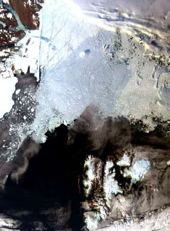
This 29 August 2006 Envisat MERIS image highlights the area North of Svalbard, Norway, where a very low sea ice concentration can be seen. The image width is about 800 km.
Satellite images of the Arctic show large openings in the perennial ice cover, yet another consequence of greenhouse warming, scientists announced this week.
The Arctic's thick perennial sea ice typically survives the warmth of the summer and lasts through the year. But satellite images taken in late August show that up to 10 percent of the perennial sea ice has been fractured by summer storms. The surprising change involves an area larger than the size of the British Isles.
The striking openings in the pack ice were found north of Svalbard, Norway and extend to the Russian Arctic all the way to the North Pole. This condition is likely due to the thinning and extra mobility in the European section of the central Arctic ice pack seen in recent years.
"This situation is unlike anything observed in previous record low ice seasons," said Mark Drinkwater of the European Space Agency's Oceans/Ice Unit. "It is highly imaginable that a ship could have passed from Spitzbergen or Northern Siberia through what is normally pack ice to reach the North Pole without difficulty."
The minimum ice extent—the lowest amount of ice recorded in the area annually—has shrunk from 3 million square miles in the early 1980's to less than 2 million square miles in 2005. A recent study showed that between 2004 and 2005, the ice shrunk by 14 percent, a decrease in area the size of Texas.
"If this anomaly trend continues, the North-East Passage or 'Northern Sea Route'between Europe and Asia will be open over longer intervals of time, and it is conceivable we might see attempts at sailing around the world directly across the summer Arctic Ocean within the next 10-20 years," Drinkwater said.
Get the world’s most fascinating discoveries delivered straight to your inbox.
What makes Earth habitable? This LiveScience original video explores the science of global warming and explains how, for now, conditions here are just right.
Sara Goudarzi is a Brooklyn writer and poet and covers all that piques her curiosity, from cosmology to climate change to the intersection of art and science. Sara holds an M.A. from New York University, Arthur L. Carter Journalism Institute, and an M.S. from Rutgers University. She teaches writing at NYU and is at work on a first novel in which literature is garnished with science.