 Live Science Plus


New Space Station Camera Snaps First Image of Earth
You are now subscribed
Your newsletter sign-up was successful
Want to add more newsletters?

Delivered Daily
Daily Newsletter
Sign up for the latest discoveries, groundbreaking research and fascinating breakthroughs that impact you and the wider world direct to your inbox.

Once a week
Life's Little Mysteries
Feed your curiosity with an exclusive mystery every week, solved with science and delivered direct to your inbox before it's seen anywhere else.

Once a week
How It Works
Sign up to our free science & technology newsletter for your weekly fix of fascinating articles, quick quizzes, amazing images, and more

Delivered daily
Space.com Newsletter
Breaking space news, the latest updates on rocket launches, skywatching events and more!

Once a month
Watch This Space
Sign up to our monthly entertainment newsletter to keep up with all our coverage of the latest sci-fi and space movies, tv shows, games and books.

Once a week
Night Sky This Week
Discover this week's must-see night sky events, moon phases, and stunning astrophotos. Sign up for our skywatching newsletter and explore the universe with us!
Join the club
Get full access to premium articles, exclusive features and a growing list of member rewards.
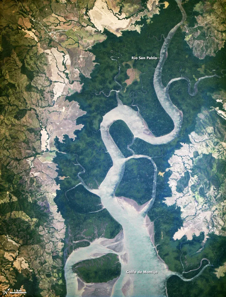
A new photo taken from the International Space Station shows an ecologically diverse area of Panama in a new light.
The picture is the first taken by a new Earth-observing tool recently installed on the orbiting science laboratory, and shows the San Pablo River emptying into the Gulf of Montijo, reported NASA's Earth Observatory.
NASA officials hope that the ISERV Pathfinder camera (short for International Space Station SERVIR Environmental Research and Visualization System) will give scientists on the ground more insight into environmental issues around the globe.
"ISERV's full potential is yet to be seen, but we hope it will really make a difference in people’s lives," principal investigator Burgess Howell of NASA’s Marshall Space Flight Center in Huntsville, Ala., told the Earth Observatory. "For example, if an earthen dam gives way in Bhutan, we want to be able to show officials where the bridge is out or where a road is washed out or a power substation is inundated. This kind of information is critical to focus and speed rescue efforts."
Controlled from Marshall, NASA scientists will use positioning software to map exactly where the space station is flying to target and photograph points of interest on the surface of the Earth.
"If there's a good viewing opportunity, the SERVIR team will instruct the camera to take high-resolution photographs at 3 to 7 frames per second, totaling as many as 100 images per pass," reported the Earth Observatory. "With a resolution down to 10 feet (3.2 m) it will be possible to spot fairly small details and objects."
The camera isn't available for this kind of research just yet, however. Engineers are still working out ISERV's kinks before starting in on basic scientific work in a few months.
The International Space Station is about the size of a football field and was built by five different space agencies representing Canada, the United States, Russia, Europe and Japan. The orbiting science laboratory is currently home to Expedition 34's six international astronauts.
Follow Miriam Kramer @mirikramer and Google+. Follow OurAmazingPlanet @OAPlanet, Facebook and Google+.

