 Live Science Plus


You are now subscribed
Your newsletter sign-up was successful
Want to add more newsletters?

Delivered Daily
Daily Newsletter
Sign up for the latest discoveries, groundbreaking research and fascinating breakthroughs that impact you and the wider world direct to your inbox.

Once a week
Life's Little Mysteries
Feed your curiosity with an exclusive mystery every week, solved with science and delivered direct to your inbox before it's seen anywhere else.

Once a week
How It Works
Sign up to our free science & technology newsletter for your weekly fix of fascinating articles, quick quizzes, amazing images, and more

Delivered daily
Space.com Newsletter
Breaking space news, the latest updates on rocket launches, skywatching events and more!

Once a month
Watch This Space
Sign up to our monthly entertainment newsletter to keep up with all our coverage of the latest sci-fi and space movies, tv shows, games and books.

Once a week
Night Sky This Week
Discover this week's must-see night sky events, moon phases, and stunning astrophotos. Sign up for our skywatching newsletter and explore the universe with us!
Join the club
Get full access to premium articles, exclusive features and a growing list of member rewards.
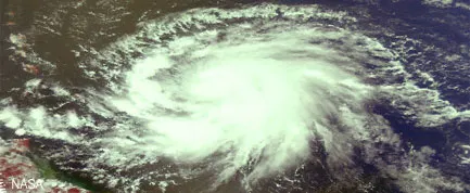
Hurricane seasons have been getting longer over the past century and the big storms are coming earlier, LiveScience has learned. The trend has been particularly noticeable since 1995, some climate scientists say. Further, the area of warm water able to support hurricanes is growing larger over time. The Atlantic Ocean is becoming more hurricane friendly, scientists say, and the shift is likely due to global warming. "There has been an increase in the seasonal length over the last century," Jay Gulledge, a senior scientist with the Pew Center on Global Climate Change, told LiveScience. "It's pretty striking." A study Gulledge co-authored with other climate scientists found a five-day increase in season length per decade since 1915. Hurricane season officially starts June 1, but the first named storm of the 2008 season, Tropical Storm Albert, formed on May 31. The first hurricane of the season, Hurricane Bertha, formed on July 1, reaching hurricane strength on July 7, relatively early in the season for a major storm. In the last decade, more strong storms have been forming earlier in the season, said hurricane researcher Greg Holland of the National Center for Atmospheric Research in Boulder, Colo. While this trend hasn't been formally linked to global warming because climate models can't reproduce individual storms, Holland thinks it's likely that the warming caused by manmade greenhouse gases is a major factor in the seasonal shift based on observations of changes in recent decades and the predictions models are making for the changing conditions in the Atlantic basin. The length of the hurricane season is "one of the potentially big signals" that could change in response to global warming, Holland said. Defining the season The definition of the hurricane season depends on who you ask: For hurricane forecasters and coastal residents living in an area prone to hurricane landfalls, the standard dates are June 1 to Nov. 30. The National Hurricane Center uses these dates because historically most storms occur within that span of six months and because having a definitive time frame helps to heighten the public's awareness of the dangers of hurricanes. But for researchers looking at how hurricane activity has changed over time, those dates don't really matter — meteorologists look at the dates of the first and last named storms in a given year, which allow them to evaluate the actual length of each hurricane season. Since 1995, hurricane seasons have been increasing in length based on the latter definition, Holland said, with stronger storms that typically wouldn't be seen until mid-August showing up in July (Bertha, which became a Category 3 storm in the Atlantic last week, is one example). Expanding warm pool Like a hurricane's intensity, the length of the hurricane season is affected by the temperature of the ocean that fuels the storms. The warmer the water, the more energy a storm has to draw from. Hurricanes and tropical storms have been forming earlier in the season recently because "we now get warmer sea surface temperatures earlier in the year," Holland explained. "The whole season has extended out." Peter Webster of Georgia Tech put a finer point on it. "There is some work that says that the length of the North Atlantic hurricane season has become longer as SSTs [sea surface temperatures] warm up more quickly early in the season," he said. Tropical storms and hurricanes need water of at least 80 degrees Fahrenheit (26.5 degrees Celsius) to form. The area where water temperatures meet or exceed that mark is called the warm pool. In recent years, the warm pool has expanded, creating a larger area over which hurricanes can develop and strengthen, Holland told LiveScience. It is now reaching all the way to the coast of Africa, allowing storms to form farther east, and so giving them more time to strengthen as they traverse the Atlantic. Bertha, for example, formed farther east than any other July storm on record. These storms that form so far over in the eastern Atlantic are called "Cape Verde-type" storms, after the chain of islands off the western coast of Africa. Cape Verde-type storms account for a major proportion of all major hurricanes (Category 3 and higher), Holland said. These storms tend to take a straight westward path across the Atlantic, avoiding land and cooler waters, which can kill a storm. Hurricane Andrew, which devastated southern Florida in 1992, and 2007's Hurricane Dean, which wreaked havoc in the state of Yucatán in Mexico, were both Cape Verde-type storms, along with Bertha. Holland thinks that the growth of the warm pool will be a factor in the length of future hurricane seasons by promoting these and other early-forming storms. Outliers
Other early storms, outliers to the standard June 1 to Nov. 30 season, such as this season's Tropical Storm Arthur or last year's Subtropical Storm Andrea (which formed on May 9), aren't all that unusual. Such early birds were seen even before global warming became an issue — the earliest-forming storm in recorded weather history was observed on March 7, 1908. "There's always been the odd one out," Holland said, adding that we'll likely see more of these in a warming world. "We have to expect that they'll be more outliers," he said, though he doubts that the official dates of hurricane season will change, since most will still lie within that window. But these aren't the early-forming storms that Holland is worried about, because they tend to be weaker. It's the major storms, like the Cape Verde-type, that are forming in July and later that are the ones to watch out for, he said. These shift to more major storms is also cause for concern because the Atlantic historically had fairly timid hurricane seasons compared to other storm-producing basins such as the Indian Ocean. Because the Atlantic basin wasn't optimized for hurricane formation already, "it didn't take much of a change to see a difference," Holland said. One other way the Atlantic basin is becoming more hurricane-friendly, besides warmer oceans, is more favorable atmospheric conditions. Warming ocean temperatures also change atmospheric circulation patterns. Holland said some changes are already happening over the Atlantic and climate models predict that these changes will also tend to promote the development of storms off the coast of Africa. "All of the stars are lining up," he said.
- 101 Amazing Earth Facts
- Video: Learn What Fuels Hurricanes
- Natural Disasters: Top 10 U.S. Threats

