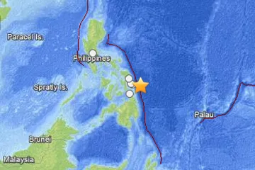
An earthquake of preliminary magnitude 7.9 struck today near the Philippines, according to the U.S. Geological Survey (USGS).
The temblor's epicenter was 66 miles (106 km) east-southeast of Guiuan on the island of Samar and 465 miles (749 km) southeast of the capital, Manila. It originated 21 miles (34 km) deep and struck at 8:47 p.m. local time (12:47 UTC), the USGS reports.
This is a major earthquake. Events of this size can cause localized devastation, especially to poorly built structures. Even well built structures can be heavily damaged or destroyed. Earthquakes of this size are often followed by significant and potentially severe aftershocks. But the damage caused by any single event depends on the quake's depth, proximity to populated areas, building standards in the region, as well as the type of earthquake. The USGS frequently updates the magnitude of an event after more data is analyzed.
Latest Videos From
An earthquake's magnitude is a measure of the energy released at the source. It is just one predictor of the shaking that may ensue, which is affected by local and regional geology. Scientists know in a general sense what causes Earthquakes but are unable to predict specific quakes.
The quake generated a minor tsunami that had essentially no effect. Significant damage was reported, and one death has been attributed to the earthquake. Find more earthquake news here.