Forecast: Dorian Will Slam into Florida As a 'Major' Category 4 Hurricane
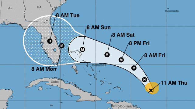
Hurricane Dorian will likely hit Florida Sunday (Sept. 1) as a Category 4 hurricane, according to the latest forecast from the National Hurricane Center.


Hurricane Dorian will likely hit Florida Sunday (Sept. 1) as a Category 4 hurricane, according to the latest forecast from the National Hurricane Center (NHC).
The storm, which dealt Puerto Rico a comparatively mild blow Wednesday (Aug. 28), has since moved a couple hundred miles north. Dorian is tracking northwest toward Florida with maximum sustained winds of 85 mph (135 km/h), making it a Category 1 hurricane now. However, the NHC said, pressure inside the hurricane has dropped significantly, which should drive the storm to strengthen into a "major hurricane" on Friday. Faster winds have likely not yet appeared, because a "double-eyewall" structure has emerged in the hurricane, temporarily limiting the most extreme winds.
Meteorologists with the NHC warned that Dorian poses a major threat to the northwestern Bahamas and the southeast coast of the United States over Labor Day weekend.
Related: Hurricane Season 2019: How Long It Lasts and What to Expect
"There is an increasing likelihood of life-threatening storm surge along portions of the Florida east coast late this weekend or early next week," the NHC said, adding that "the risk of devastating hurricane-force winds along the Florida east coast and peninsula late this weekend and early next week continues to increase."

Dorian's forecast map as of 11 am EST, August 29 shows that it will likely strengthen and move toward Florida.
It's too soon to predict precisely where the worst effects will happen, the NHC said. But already, forecasters expect that a wide region should experience heavy rainfall as the storm hits and moves inland next week, which may cause life-threatening flash floods.
The time to begin preparing for the storm in Florida and the northwestern Bahamas, the center said, is now.
Get the world’s most fascinating discoveries delivered straight to your inbox.
- Hurricanes from Above: Images of Nature's Biggest Storms
- Photos: Hurricane Michael Toppled Over Trees and Uprooted 19th Century Artifacts
- Inside Irma's Eye: Hurricane Hunters Capture Jaw-Dropping Photos
Originally published on Live Science.


 Live Science Plus


