It's quick and easy to access Live Science Plus, simply enter your email below. We'll send you a confirmation and sign you up for our daily newsletter, keeping you up to date with the latest science news.
When a volcano in Ethiopia erupted in January, volcanologists hoped a NASA satellite would be able to train its eyes on the explosive event and capture photos. It turned out that a satellite was already a few steps ahead and had already begun observing the volcano, thanks to an artificial intelligence program on board.
The Autonomous Sciencecraft Experiment (ASE) is an artificial intelligence (AI) software that has guided the activities of NASA's Earth Observing 1 (EO-1) spacecraft for more than 12 years, according to NASA. The EO-1 satellite was launched in 2000 as an experimental Earth-science satellite, and was outfitted with the AI guide in 2003. With the assistance of the ASE, the satellite can detect changes of scientific interest on Earth (i.e. volcanic eruptions, wildfires and flooding), alert researchers and autonomously take photos of the events.
This month, NASA will be retiring the EO-1 satellite, and agency researchers said the recent volcanic activity in Ethiopia was a fitting end to the satellite's mission. [The 11 Biggest Volcanic Eruptions in History]
"We caught this event at the perfect time, during an early, developing phase of the eruption," Ashley Davies, lead scientist for ASE and a volcanologist at NASA's Jet Propulsion Laboratory (JPL), said in a statement. "This simply wouldn't have happened without the Volcano Sensor Web."
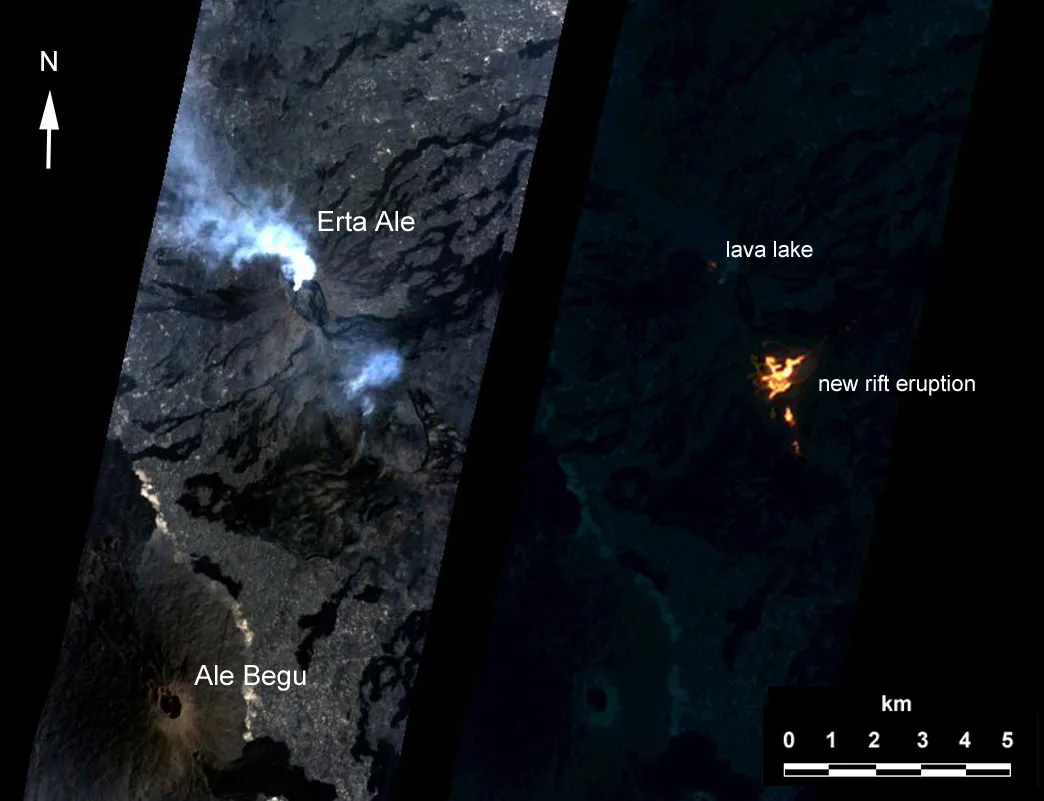
The Volcano Sensor Web is a network of satellites (including EO-1) and ground sensors that is tasked with monitoring changes such as rapid temperature increases on the planet. In late January, one of the satellites in the network detected changes in Erta Ale's lava lake in Ethiopia, and pinged the EO-1 satellite to capture images of the volcano.
Known as the "smoking mountain" and the "gateway to hell," Erta Ale is Ethiopia's most active volcano. The shield volcano is located in Africa's Danakil (or Afar) Depression, where three tectonic plates are separating, triggering volcanic activity along the seams. Erta Ale is also one of the few volcanoes in the world that has an active lava lake at its caldera, the basin-shaped depression that forms after an eruption.
Thanks to the EO-1 satellite's quick response to the activity, NASA researchers said they can review images of Erta Ale to study how the discharge of lava changes over time.
Sign up for the Live Science daily newsletter now
Get the world’s most fascinating discoveries delivered straight to your inbox.
NASA's EO-1 spacecraft obtained images of the continuing eruption of Chile's Puyehue-Cordon Caulle volcano.
Erta Ale was not the only volcano on EO-1's radar during the satellite's more-than-a-decade-long run. NASA researchers used the ASE on board EO-1 to study the eruption of Chile's Puyehue-Cordon Caulle volcano in 2011, and an Icelandic volcano's eruption in 2010. The software was not limited to covering volcanic activity, however, and also helped monitor severe flooding in Thailand in 2011.
"It's a milestone in AI application," said Steve Chien, principal investigator of ASE and head of the Artificial Intelligence Group at JPL. "We were supposed to do this for six months, and we were so successful that we did it for more than 12 years."
Though EO-1 and its AI program, ASE, are headed for retirement, future research will continue the pursuit of satellite autonomy, Chien and Davies said.
Kacey Deamer is a journalist for Live Science, covering planet earth and innovation. She has previously reported for Mother Jones, the Reporter's Committee for Freedom of the Press, Neon Tommy and more. After completing her undergraduate degree in journalism and environmental studies at Ithaca College, Kacey pursued her master's in Specialized Journalism: Climate Change at USC Annenberg. Follow Kacey on Twitter.