
 Live Science Plus


Arlene Could Become a Hurricane Before Hitting Florida

Updated at 5:30 p.m. ET
Tropical Storm Arlene could become a hurricane before hitting the U.S. Gulf Coast over the weekend, forecasters said Friday.
Arlene strengthened steadily Thursday night and early Friday as it drenched parts of Cuba and took direct aim on the U.S. coast.

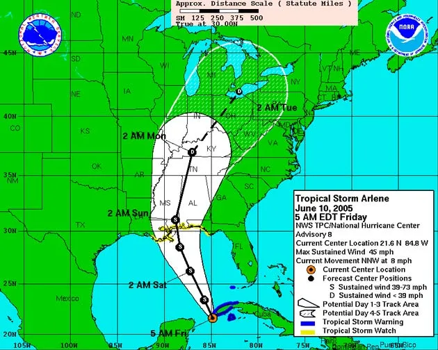
The storm's top sustained winds were near 65 mph by late afternoon, up from 45 mph in the morning, with higher gusts. Forecasters at the National Hurricane Center said Arlene is likely to get stronger before it makes landfall late Saturday or early Sunday [Map].
Tropical storm winds run from 39 mph to 74 mph, the threshold for hurricane status.
A hurricane watch was issued for a region of the Florida Panhandle from the mouth of the Pearl River to Indian Pass. A watch means hurricane conditions are possible within 36 hours.
A tropical storm warning was issued from Grand Isle, Louisiana to Steinhatchee, Florida. A warning means tropical storm conditions are expected within 24 hours.
Get the world’s most fascinating discoveries delivered straight to your inbox.
"Some strengthening is forecast during the next 24 hours, and it is possible that Arlene could reach hurricane strength before making landfall," read a statement from the hurricane center.
At 5 p.m. ET Arlene's center was about 335 miles southeast of the mouth of the Mississippi River. It was moving north at about 17 mph, a quicker pace than at in the late morning by about 3 mph.
The storm center is expected to approach the coast Saturday, but much of its weather will arrive earlier, forecasters said, because the bulk of the clouds and moisture are ahead of the center [Satellite view].
Tropical storm force winds extend northward 150 miles from the system's center.
Forecasters' best guess brings Arlene ashore near the Florida-Alabama border.
Because hurricanes rotate counterclockwise, the worst effects of the storm would be on the right side, looking down. That's where internal winds combine with the storm's forward speed to make the strongest net winds. It's also where a storm surge of 2 to 4 feet may combine with battering waves to pound the shore.
Parts of Florida can expect 3 to 5 inches of rain, with up to 7 inches in isolated spots. Isolated tornadoes are possible, as is often the case with tropical storms.
Arlene represents a fairly early start to the hurricane season, which began officially June 1. The busiest months are traditionally August and September. Last year's first tropical storm did not form until Aug. 1.
The Atlantic basin hurricane season runs through the end of November. Forecasters said they expect a busy year again on the heels of last year's battering of Florida and other states. Active hurricane seasons tend to come in packs, scientists have learned.

Storm Central Hurricane News, plus the deadliest and costliest of all time, busiest months, worst states, and this year's storm names
How & Where Hurricanes Form The science of monster storms.
Busy 2005 Season Predicted The official season forecast from the National Hurricane Center.
The Deadly 2004 Season Officials say lessons learned will save lives in the future.
Rare One-Two Punch A pair of tropical storms are imaged at once.

Robert is an independent health and science journalist and writer based in Phoenix, Arizona. He is a former editor-in-chief of Live Science with over 20 years of experience as a reporter and editor. He has worked on websites such as Space.com and Tom's Guide, and is a contributor on Medium, covering how we age and how to optimize the mind and body through time. He has a journalism degree from Humboldt State University in California.