


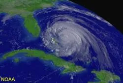
Deadly Hurricanes of 2004 Will Save Lives
"Hurricane damage is not always inevitable or an act of God"
-- Civil engineer David Prevatt
The catastrophic Atlantic hurricane season that ended this week wrought destruction and tragedy, but it also delivered unprecedented data that will help secure homes and save lives in future storms.
Research done by scientists who purposely drove and even flew on airplanes into the paths of hurricanes this summer will also make future storm forecasts more accurate.
The season, which runs from June 1 to Nov. 30, first turned violent in mid-August when Hurricane Charley plowed into southwestern Florida. Hurricanes Frances, Ivan, and Jeanne followed.
The close sequence of the storms, especially with Jeanne on the heels of Frances, gave scientists a chance to see how hurricanes compound, a key to planning for future hurricane seasons which are likely to continue accelerating.
Into the eye
Get the world’s most fascinating discoveries delivered straight to your inbox.
As hundreds of thousands of Floridians fled Charley, a team of students and engineers from as far off as Texas headed toward the eye of the storm to conduct hurricane reconnaissance.
They erected 33-foot-tall wind-speed measuring towers on several 4,500-pound steel-reinforced platforms -- in less than 20 minutes -- smack in the center of harm's way.
"There is a method to the madness to minimize spot decisions, and the students practiced in advance," Clemson University civil engineer David Prevatt told LiveScience.
Prevatt was part of the team that included scientists from Clemson, University of Florida, Gainesville, and Florida International University. The engineers repeated their efforts during the three subsequent hurricanes.
The team also enlisted homeowners to help install devices resembling frying pans on their roofs. These "taps" measured wind pressure on building surfaces and sent data to a computer in a strong box on the ground.
For the first time ever, wind speed and pressure data were collected simultaneously during hurricanes, Prevatt said.
"We are very excited to be the first to collect this data," he said. "It is indeed a milestone for wind engineering."

A house with pressure sensors installed for measurements during Hurricane Floyd in 1999.

A wind speed measuring tower deployed during Hurricane Isidore in 2002.
Images: Florida Coastal Monitoring Program
Data from the sturdy, portable weather stations, built to withstand winds of up to 200 mph, help civil engineers precisely model "lift-off" forces that can strip roofs. The goal is to improve building techniques and codes to secure homes in the face of future disasters.
"It's a question of understanding that hurricane damage is not always inevitable or an act of God," Prevatt said.
Later, Clemson researchers will compare the wind-speed data and wind-pressure readings gathered during the four hurricanes with results from model houses that will be blown apart in Clemson's Wind Load Test Facility. There, they will test their models for applicability to the real world.
"This season presented a unique educational opportunity to apply our tools and knowledge in a real hurricane," said Clemson civil engineering graduate student Cos Gardner, who was part of the team in Florida. "It's exciting."
The combination of Charley, Frances, Ivan and Jeanne caused damage costing $49 billion, surpassing the $34.9 billion caused in 1992 by Hurricane Andrew, the nation's most costly single storm, according to the Associated Press. The hurricanes also took the lives of more than 100 Americans.
Out to sea
A separate effort to save lives and property with better storm prediction during future hurricanes was undertaken by the Office of Naval Research (ONR).
The rapid-fire hurricanes barely gave ONR researchers time to rest between flights aboard two U.S. Air Force C130J Hercules aircraft that took them into the hearts of the four storms. Their project involved dropping instruments called drifters and floaters into the paths of the hurricanes. The result was a breakthrough in hurricane and oceanographic research, said ONR program manager Carl Friehe.
Real-time data sent back by the seafaring instruments will allow scientists to study the energy exchanges between the ocean and atmosphere during a hurricane and how those interactions affect a storm's intensity.
Hurricanes thrive on warm tropical water. The ocean's heat is picked up by the hurricane, forcing air to rise. The rising air near the center of a storm acts like a chimney, and causes more air to be pulled in at the surface -- generating a storm's wind.
Better understanding of these energy exchanges can help scientists develop more accurate models for predicting a hurricane's development. Hurricane intensity determines the size of the storm surge of water that precedes it. Storm surges can pose a significant threat to shoreline inhabitants and ships in port.
The drifting sensors remain on the ocean's surface, floating like bottles with a message that is constantly updated as their instruments measure air pressure, wind speed and direction, and sea surface temperature.
The floaters, programmed by the University of Washington Applied Physics Laboratory and the Scripps Institution of Oceanography, bob up and down through the upper 650 feet (200 meters) of the ocean. They record water temperature, salinity, dissolved gases, and velocity. They're better than satellites, which only read information on the surface of the ocean down to an eighth of an inch.
But a hurricane churns the sea, pulling cooler water from below to the surface. This upwelling can serve as a throttle to a stagnant hurricane -- one that has lost its forward speed. And cooler water in the wake of one hurricane can inhibit the development of a second storm that might take the same course days later.
Together, the instruments returned profiles over time of ocean upwelling and mixing caused by the hurricanes, including the first-ever data showing the mixing that occurred when Jeanne followed closely on the path of Frances.
The combination of atmospheric and ocean science, technology, deployment via aircraft, and the need for better hurricane forecasting all came together in 2004 to mark a sea change in hurricane research, Friehe said.

Robin Lloyd was a senior editor at Space.com and Live Science from 2007 to 2009. She holds a B.A. degree in sociology from Smith College and a Ph.D. and M.A. degree in sociology from the University of California at Santa Barbara. She is currently a freelance science writer based in New York City and a contributing editor at Scientific American, as well as an adjunct professor at New York University's Science, Health and Environmental Reporting Program.