


Storm Chasers Cast New Eye on Tornadoes
Tornado chasers have a new tool to add to their arsenal aimed at tracking and understanding the deadly beasts.
A fast-scanning, mobile radar unit allows researchers to take the best ever images of brewing twisters.
Traditional radar scanning techniques take two dimensional images of tornadoes using only one radar beam at a time. This method can take more than five minutes to stack 2-D images to build a 3-D image of a tornado. That's too slow in the game of storm chasing.
Rapid scanning radar, which is being used in the field for the first time this season, improves the efficiency of tornado imaging considerably, building a "layer cake" of tornado images in a matter of seconds.
"With rapid scanning radar we can rake the sky with six beams simultaneously," tornado expert Joshua Wurman told LiveScience. "We need 10 to 15 2-D images to create one 3-D image, and we can do that every 5 to 10 seconds.
Hurry, hurry
A tornado changes dramatically as it churns. Mobile radar has been employed for several years now, but the new imaging equipment offers a huge advantage over the older methods in capturing the evolution of a storm.
Get the world’s most fascinating discoveries delivered straight to your inbox.
"It's very important to get images of tornadoes very rapidly," said Wurman, based at the nonprofit Center for Severe Weather Research, which is funded in part by the National Science Foundation. "If there's too much time in between images, we can't tell how it got from point A to point B."
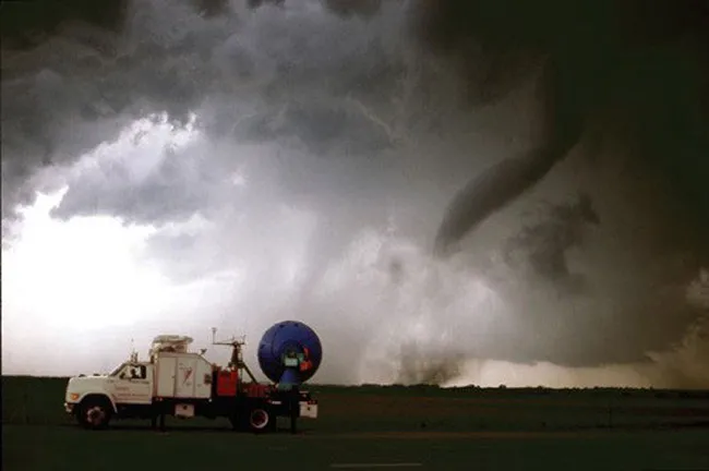
In the world of tornado imaging, the closer you can get to the tornado, the better. Wurman uses a Doppler on Wheels - a fancy name for a truck with a radar mounted on its back - to accomplish this.
"We try to get 3 to 5 miles ahead of the tornado and park in its path to take pictures," Wurman said. "Images 1 mile from the tornado have resolution 1,000 times better than images taken from 20 miles away."
Find and chase
Wurman and his crew look at storm patterns in the Great Plains region and pick a target region based on storm forecasts. They scan storms with their radar and pick those that have the best chance of producing a tornado.
"And then we head for it," Wurman said. "We're constantly jockeying for position."
So why would scientists put themselves right in the path of such destructive forces?
"We don't really understand which storms will and which storms won't produce tornadoes. If we did, we could give better warnings," Wurman said. "We could also forecast their intensity. Tornadoes with winds of 120-130 miles an hour aren't that bad. Most fatalities are caused by F4 and F5 tornadoes, which have winds around 300 mph. We need to be able to forecast those."
Over the last nine years, Wurman and his colleagues have collected data on over 100 tornadoes. This tornado season has been fairly slow, with twisters turning up at about half the normal rate.
Still, Wurman hopes to intercept five to 10 tornadoes between now and the end of June.
Related Stories
- Tornado Science, Facts and History
- Top 10 Killer Tornadoes
- The Worst Outbreak in Tornado History
- 2004: A Record Year for Tornadoes
- The Odds of Dying
Image Gallery

Inside Look
((ImgTag||right|null|null|null|false)) Images of tornadoes provided by the new mobile radar setup.
Credit: CSWR