It's quick and easy to access Live Science Plus, simply enter your email below. We'll send you a confirmation and sign you up for our daily newsletter, keeping you up to date with the latest science news.
(Image credit: NASA Goddard/MODIS Rapid Response Team)
This stunning visible image of Hurricane Michael was taken by the MODIS instrument aboard NASA's Aqua satellite on Sept. 6 at 12:20 p.m. EDT. Michael's eye is so clear that the ocean surface is visible through it.
Tropical Storm Nadine
(Image credit: NASA's GOES Project)
This visible image of Tropical Storm Nadine was captured by NOAA's GOES-13 satellite at 1445 UTC (10:45 a.m. EDT) on Sept. 12, 2012. The image shows that Nadine is developing a central dense overcast and bands of thunderstorms all around the storm.
Tropical Storm Oscar
(Image credit: NASA JPL, Ed Olsen)
NASA's Aqua satellite passed over Tropical Storm Oscar on Oct. 4, 2012, at 9:35 a.m. EDT (1335 UTC) when the bulk of Oscar's clouds and showers were southeast of the center of circulation as a result of northwesterly wind shear.
Tropical Storm Rafael is seen here northeast of Puerto Rico, as captured by NASA's Aqua satellite on Oct. 14, 2012.
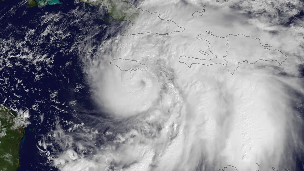
Hurricane Sandy
(Image credit: NOAA)
NOAA's GOES East satellite snapped this image of Hurricane Sandy at 10:45 a.m. EDT (1445 UTC) on Oct. 24, 2012, as it was headed for landfall on Jamaica.
Tropical Storm Tony
(Image credit: NASA GOES Project)
NOAA's GOES-13 satellite captured an image of Tony on Oct. 24 at 7:45 a.m. EDT that revealed that Tony is relatively small as it moves through the central Atlantic.
Sign up for the Live Science daily newsletter now
Get the world’s most fascinating discoveries delivered straight to your inbox.
For the science geek in everyone, Live Science offers a fascinating window into the natural and technological world, delivering comprehensive and compelling news and analysis on everything from dinosaur discoveries, archaeological finds and amazing animals to health, innovation and wearable technology. We aim to empower and inspire our readers with the tools needed to understand the world and appreciate its everyday awe.