


Satellite Spies Powerful Hurricane in Swirling 3D
A NASA satellite sailed over powerful Tropical Cyclone Jasmine, a storm raging in the South Pacific this week, allowing scientists to see a 3D version of the hurricane's swirling clouds and heavy rain.
(The storm is officially known as Tropical Cyclone Jasmine due to regional differences in storm-naming practices. If it were in the Atlantic Ocean, it would be officially known as Hurricane Jasmine. Tropical cyclones, typhoons and hurricanes are simply different words for the same phenomenon.)
Although Jasmine is a relatively small storm, only about 100 miles (160 km) in diameter, it packs a powerful punch, as captured in a real-color image of the storm snapped by a NASA satellite on Wednesday (Feb. 8).
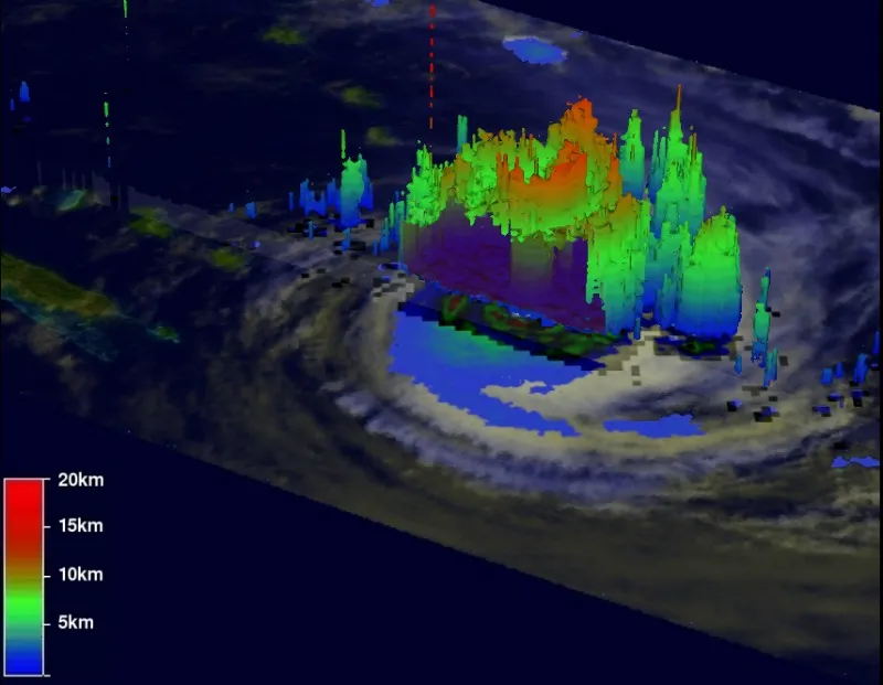
NASA's TRMM instrument, which takes three-dimensional profiles of clouds and rainfall, showed that powerful thunderstorms wrapped around Jasmine's eye were dropping more than 2 inches (5 cm) of rain per hour, and measured storm clouds 7 miles (11 km) high.
At its peak, Jasmine was a Category Four storm with maximum sustained winds of about 132 mph (212 kph). When the 3D image was snapped on Wednesday, the storm had begun to weaken.
On land, Category Four storms can cause catastrophic damage, according to the National Hurricane Center, yet Jasmine hasn't veered toward large human populations, and so far, no casualties have been reported.
Yesterday (Feb. 9), the storm was a few hundred miles east of the northern tip of New Zealand, in the middle of the South Pacific Ocean.
Get the world’s most fascinating discoveries delivered straight to your inbox.
This morning, Jasmine's maximum sustained winds were about 86 mph (138 kph), according to the most recent update from the U.S. Navy's Joint Typhoon Warning Center, issued at 5 a.m. ET.
The storm is skirting cooler waters today (Feb. 10), and is expected to weaken further.
- 8 Terrible Typhoons
- Storm Season! How, When & Where Hurricanes Form
- In the Eye of the Storm: NASA's Hurricane Hunters
Follow OurAmazingPlanet for the latest in Earth science and exploration news on Twitter @OAPlanet and on Facebook.
