NASA satellites are helping analyze the damage from the deadly tornadoes that raked the southeastern United States in April, aiding ground surveys that may improve emergency response to these disasters, scientists say.
The tornado outbreak lasted several days and peaked on April 27, when a round of twisters carved their way across Mississippi, Tennessee, Alabama and Georgia, killing more than 300 people and causing extensive damage. Sixty-two tornadoes were confirmed in Alabama alone, nearly half of which had estimated wind speeds of more than 110 mph (180 kph).
"The April 25 to 28, 2011, period was overwhelming in terms of the number of tornadoes produced , the amount of damage, and the number of communities impacted," said researcher Andrew Molthan, a meteorologist at NASA's Marshall Space Flight Center in Huntsville, Ala.
Latest Videos From
Damage surveys
After such episodes of severe weather, National Weather Service meteorologists conduct ground surveys to estimate the strength of a storm based upon visible damage and, often, interviews with witnesses.
"The knowledge gained provides the research community with a link between observations, such as radar, and events that are occurring at the surface," Molthan told OurAmazingPlanet. "These activities help meteorologists to improve future warnings by having a better understanding of how storm structure relates to the specific hazard tornado, wind, hail."
"Ground surveys affect residents in a more tangible way," Molthan added, "as other federal agencies such as FEMA [the Federal Emergency Management Agency] and state and local emergency management agencies no doubt use these storm assessments to understand who has been affected, the estimated cost of the damage, and how they can best respond."
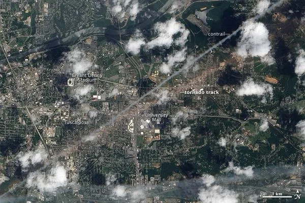
In addition to surveying damage on the ground, scientists employed satellites to help provide a complete picture of the devastation. Data from the Moderate Resolution Imaging Spectroradiometers (MODIS) aboard NASA's Terra and Aqua satellites helped image conditions before and after the storms. [See satellite images of the tornado damag e.]
"Ground surveys can be limited because of poor road networks in complex terrain, damage that limits travel in an area or other constraints," Molthan explained. "Satellite data can help by providing a broader perspective of the path length and sometimes width to corroborate the ground survey or help fill in gaps where the survey may be incomplete."
Altogether, this data helped identify the swaths of destruction the April tornadoes left in their wake. By measuring specific wavelengths of light, the satellites can sharply reveal where vegetation has been scoured away.
Tornado tracks revealed
Satellites revealed several damage tracks across the Southeast evidently caused by rotating thunderstorms, or "supercells," observed by National Weather Service Doppler radars in Mississippi, Alabama and Georgia. These supercells generated many of the strongest, longest-lived and widest-track tornadoes.
At 800-foot (250-meter) resolution, satellite imagery captured all but one of the damage paths from the strongest tornadoes , which had wind speeds of 136 mph (219 kph) or greater. Those of several weaker tornadoes were seen as well.
In addition, the Advanced Spaceborne Thermal Emission and Reflection Radiometer (ASTER) aboard the NASA Terra satellite has a higher spatial resolution of up to 50 feet (15 m). "You can actually see surface road networks, urbanization and differences in land use among agricultural and natural scenes," Molthan said. Although ASTER data are more limited in coverage than MODIS, it still was useful in examining damage from the powerful tornado that ripped through the town of Phil Campbell, Ala., he said.
"One challenge for the remote sensing of damage tracks is that the damage must cause a significant change in the characteristics of the surface," Molthan cautioned. "For example, our use of MODIS data in Alabama worked very well in parts of the state that are forested because large, strong tornadoes uprooted or damaged these trees and either exposed the bare soil below or caused enough loss of vegetation that this change was detectable.
"In other cases, such as the agricultural areas southwest of Huntsville, Ala., and along the Tennessee River, large tornadoes occurred but could not produce as significant of a change in the surface characteristics because there just wasn't much in the fields to disrupt," Molthan said. "In addition, our current technique emphasizes vegetation change and may not perform as well in urban areas."
Future efforts will focus on image-enhancement techniques to improve storm damage detection in urban areas, as well as on applying such research across the broader United States, Molthan said.
The scientists detailed their findings in the Oct. 4 issue of the journal Eos.