Our amazing planet.

Rivers Swell Across Midwest

midwest-flooding-110414-02
(Image credit: NASA/MODIS Rapid Response Team)

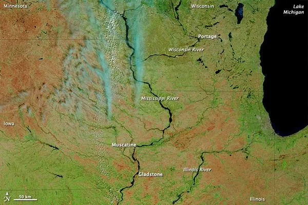
Waters continued rising in April 2011 in the U.S. Midwest, according to a NASA statement. On April 13, the Advanced Hydrological Prediction Service (AHPS) of the U.S. National Weather Service warned of flooding along the Mississippi and Wisconsin Rivers . The AHPS reported major flooding of the Wisconsin at Portage, and varying degrees of flooding at many locations along the Mississippi, including Muscatine and Gladstone.

The Moderate Resolution Imaging Spectroradiometer (MODIS) on NASA's Terra satellite acquired these images on April 12, 2011 (top), and March 2, 2011 (bottom). Both images use a combination of infrared and visible light to increase the contrast between water and land.

(Image credit: NASA/MODIS Rapid Response Team)

Snow is turquoise; water is navy; and iced-over water bodies are bright blue. Clouds range in color from blue-green to nearly white. Vegetation is green and soil is earth-toned. The redder hues in the April image may result from the angle of the satellite sensor.

Snow blankets roughly the northern third of the area in early March, and ice appears along the Mississippi River. Several weeks later, the snow has disappeared, and the Mississippi has widened downstream. Nearly invisible in early March, the Wisconsin River is easily identified in April. The Illinois River, in contrast, appears to show little change.

Live Science Staff
For the science geek in everyone, Live Science offers a fascinating window into the natural and technological world, delivering comprehensive and compelling news and analysis on everything from dinosaur discoveries, archaeological finds and amazing animals to health, innovation and wearable technology. We aim to empower and inspire our readers with the tools needed to understand the world and appreciate its everyday awe.