While the Northern Hemisphere is headed toward winter, the Antarctic Peninsula's ice has begun melting with the onset of spring.
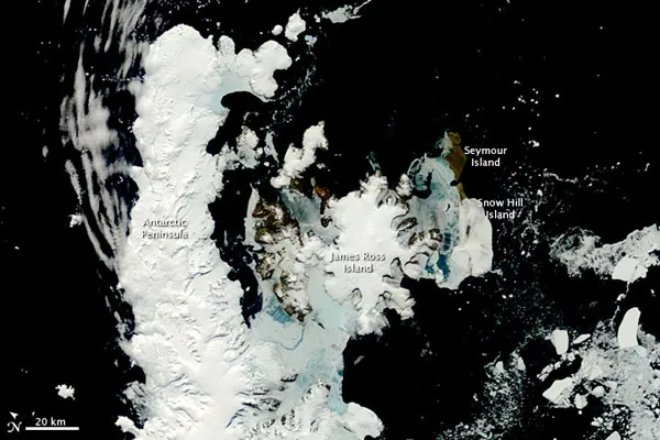
This Nov. 15 image from NASA's Terra satellite caught this rare, nearly cloud-free view of the northern tip of the Antarctic Peninsula, as the sea ice began to melt.
The peninsula and its surrounding islands are rapidly losing the shield of sea ice that surrounds them in winter. Winds from the west have also been pushing the ice eastward. These eastward-blowing winds channel down the mountains, bringing warmer air to the east side of the peninsula, and causing the remaining sea ice around the James Ross, Seymour and Snow Hill Islands to melt.
Latest Videos From
The Antarctic Peninsula is the northernmost part of the mainland of Antarctica . The peninsula extends from a line between Cape Adams in the Weddell Sea, and a point on the mainland south of the Eklund Islands. The peninsula forms part of disputed and overlapping claims by Argentina, Chile and the United Kingdom, and various other nations have research stations spread throughout the area.
Scientists have been focusing on the Antarctic Peninsula because it has warmed significantly since weather stations began collecting data there in 1903. In the past decade, warming has led, at least partially, to the collapse of the Larson B and Wilkins Ice Shelves. The ice shelves used to act as plugs that would slow the flow of glaciers from the mountainous peninsula into the ocean. With the shelves gone, the glaciers accelerated their flow, rapidly shedding ice into the Southern Ocean.
In an attempt to better monitor the changes occurring in the ice coverage of the Antarctic Peninsula, NASA scientists are flying over the area in a plane equipped to measure how the ice is changing. So far, many glaciers, including the Crane Glacier, have not slowed their flow. The flights are part of NASA's six-year IceBridge Mission .

 Live Science Plus