


Mid-Atlantic Major Snow Potential Next Week
This article was provided by AccuWeather.com.
A wintry system that will make a cross-country tour beginning this weekend has the potential to develop into a major storm along the East Coast next week.
The storm is cruising northern Pacific waters to close out this week and will push into the Pacific Northwest this weekend with a modest dose of rain and mountain snow.

In fact, most of the life of this storm as it traverses the Northwest (March 2-3), then the northern Rockies and central Plains into early next week (March 3-4) will not be blockbusting news.

Through this point, the storm will tend to bring travel disruptions typical of the winter months with a swath of light to moderate snow. On a positive note, the storm will provide some moisture to a needy area. (States in the path of the modest storm to this point include, but are not limited to, Washington, Oregon, Idaho, Wyoming, Montana, North Dakota, South Dakota, Minnesota, Nebraska, Iowa and Missouri).

However, toward the middle of next week (March 4-5), as this storm crosses the Mississippi River, changes taking place in the upper atmosphere will favor gradual strengthening to the Atlantic coast. Moisture will begin to feed into the storm from the Gulf of Mexico, and we are likely to start to see heavier precipitation in the form of snow, rain and thunderstorms from the Ohio Valley states to parts of the South and the mid-Atlantic. (States likely to be most involved at this point include Illinois, Indiana, Ohio, Kentucky, Tennessee, Mississippi, Alabama, Georgia, Florida, South Carolina, North Carolina, Virginia and West Virginia).
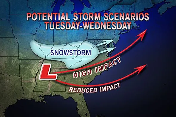
Once the storm reaches the Atlantic coast Wednesday into Thursday (March 6-7), conditions at most levels in the nearby atmosphere and well away from the storm throughout North America will favor explosive development.
Get the world’s most fascinating discoveries delivered straight to your inbox.

The track of this atmospheric bomb will determine whether or not portions of the mid-Atlantic have a foot or more of windswept snow, travel mayhem, power outages and the whole nine yards with a storm hugging the coast or another non-event with the storm heading out to sea. (States on the bubble for a major storm or a near-miss include Maryland, Delaware, Pennsylvania, New Jersey, New York, Connecticut, Rhode Island and Massachusetts, as well as the District of Columbia).
Other Stories of Interest: Blocking Pattern Favors More Big Storms Cold, Wind Head South for Spring Break Blizzards Bring Drought Relief to Winter Wheat
At this point, it is certainly not worth altering plans, but rather something to keep an eye on and perhaps come up with "Plan B" in case a major blizzard unfolds and wallops areas from Richmond and Washington, D.C., to Philadelphia and New York City Wednesday into Thursday.
As the track develops over land this weekend, we will have more information to pass along to followers on AccuWeather.com related to the timing of the precipitation and amount of snow and severity of any rain, thunderstorms and coastal flooding.
Some of the early weather-related problems with the storm in the Northwest this weekend will be drenching rain along the coast and snow dipping to pass levels. As with many storms that bring snow to the high country and shifting snow levels in the Northwest, there is a risk of avalanches.
This story was originally published at 10:30 a.m. EST, Thurs., Feb. 28, 2013. More storm-specific graphics forthcoming.
© AccuWeather.com. All rights reserved. More from AccuWeather.com.
The only sure thing about weather forecasts is that they’re wildly different all over the planet. Test your knowledge on the wild ranges in temperature, precipitation and more.
Extreme Weather Facts: Quiz Yourself
