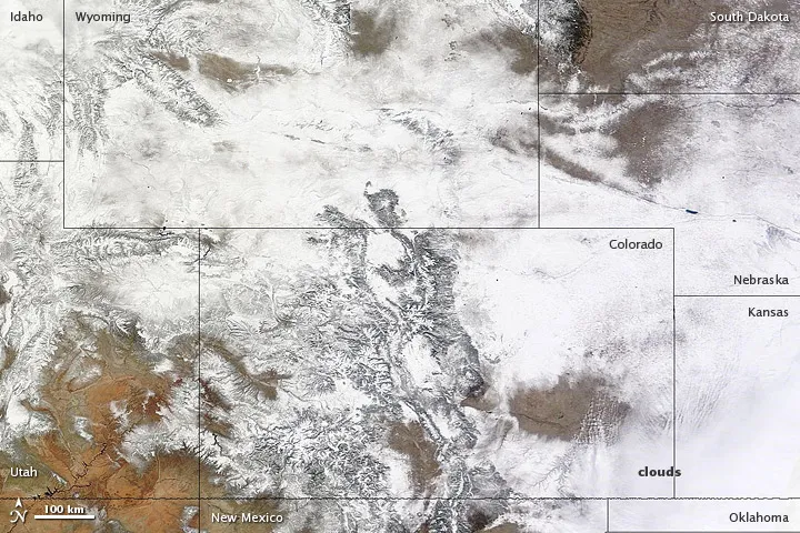
A large storm system is moving eastward across the central United States, leaving record amounts of snow through the area. From its vantage point in orbit, NASA's Terra satellite captured an image of what all the white stuff looks like from space.
The image, provided by the NASA Earth Observatory, shows snow blanketing much of Colorado and surrounding states yesterday (Feb. 25). Down on the ground, more than 27 inches (69 centimeters) of snow accumulated near Denver, according to the National Weather Service (NWS).
The system dropped nearly 7 inches (17.8 cm) of snow in Wichita, Kan., bringing the February total to 21 inches (53 cm), the most snow the city has seen in any month since records have been kept.
Latest Videos From
The low-pressure system also dropped a record amount of snow in Texas, accumulating up to 17 inches (43 cm) in Amarillo. Yesterday, the Amarillo International Airport recorded a hurricane-force 75-mph (121 km/h) gust of wind. In Oklahoma, a state of emergency was declared for 56 of 77 counties, according to Reuters. [Intense Texas Blizzard Caught in Videos]
The same system is expected to hit Chicago and Detroit by this evening (Feb. 26), perhaps bringing as much as 6 inches (15 cm) of snow to those locales, just in time to snarl rush-hour traffic, according to the NWS.
At least three deaths have been blamed on the storm, which has created hazardous driving conditions, the Associated Press reported. Wind gusts of up to 30 mph (48 kph) have created drifts up to 2 feet (61 cm) high throughout the area, reducing the visibility to nearly zero in some areas, the AP said.
Reach Douglas Main at dmain@techmedianetwork.com. Follow him on Twitter @Douglas_Main. Follow OurAmazingPlanet on Twitter @OAPlanet. We're also on Facebook and Google+.

 Live Science Plus