 Live Science Plus


Sandy Potential Impacts Norfolk to NYC, Boston
This article was provided by AccuWeather.com.
Depending on the path of Sandy, now brewing in the Caribbean, people along the East Coast during the week of Halloween could be looking a destructive storm or breathing a sigh of relief.
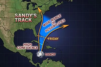
Article continues belowTropical Depression 18 formed in the central Caribbean during midday Monday and strengthened into Tropical Storm Sandy six hours later. As of Wednesday morning, Sandy was just below hurricane strength with an increase in forward movement toward Jamaica.
The AccuWeather.com Hurricane Center is confident that Sandy will head northward through Thursday, spreading life-threatening flooding rain across Jamaica, Hispaniola, eastern Cuba and the Bahamas.
Sandy is forecast to become a hurricane Wednesday.
RELATED:
Current Statistics of Tropical Storm Sandy
AccuWeather.com Hurricane Center
Jamaica to Bahamas Face Sandy's Wrath First
Another Tropical Depression Forms in the Atlantic
Will the Elections be Impacted by the Storm?
How Sandy tracks Friday and beyond is dependent on several weather factors, which at this time are very complex. These scenarios range from a disruptive and destructive hybrid between a hurricane and powerful nor'easter to a miss and a simple change to cooler weather for the East Coast.
The worst case scenario for the East Coast involves Sandy paralleling the coast from Florida to the Carolinas this weekend before being drawn inland over the mid-Atlantic or New England early next week.
While the Southeast coast would face heavy rain, strong winds and rough surf, far more serious impacts await communities from Virginia to Maine if this solution pans out.
Reminiscent of the "Perfect Storm" during the week of Halloween 1991, damaging winds and significant storm surge would unfold near and northeast of its center along the coast. Similar to the 1991 storm, these conditions could last for days.
In addition, if the storm were to move inland, unlike the storm in 1991, torrential rain would blast the I-95 corridor and heavy, wet snow would evolve over part of the Appalachian Mountains on the system's western and southwestern flank.
A powerful hybrid storm curving inland over the Northeast would bring major disruptions to travel, flooding, many downed trees and widespread power outages.

However, the above solution is far from set in stone.
There is equal possibility that the jet stream will sweep east fast enough to offer the East Coast protection from Sandy. A push of cooler air and spotty showers would be the result.
Bermuda may then become the storm's target.
Yet another solution would spare the East Coast of a direct hit but would still bring Sandy close enough to graze the coastline with several days of gusty winds and rough surf and seas.
The bottom line is that while uncertainty exists with Sandy's final destination, this is a storm that should be monitored closely by all residents from Florida to the Northeast.

Expert Senior Meteorologist Alex Sosnowski contributed to the content of this story.
AccuWeather.com. All rights reserved. More from AccuWeather.com.
