It's quick and easy to access Live Science Plus, simply enter your email below. We'll send you a confirmation and sign you up for our daily newsletter, keeping you up to date with the latest science news.
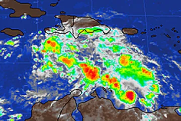
As we enter the twilight of hurricane season in the Atlantic Basin, a broad area of showers and thunderstorms in the Caribbean is creating concern.
Centered south of Hispaniola and the Virgin Islands, the currently disorganized tropical wave is bringing showers and thunderstorms to much of the central Caribbean.
Conditions in the region are forecast to become more favorable for development over the next several days as this system moves westward, and it may organize enough to become the 18th named storm of the year in the Atlantic.
If organization does occur, the next name on the 2012 list in the Atlantic Basin would be Sandy.
Computer forecasts show the tropical wave becoming more organized by Tuesday, south of Hispaniola and southeast of Jamaica. Forecast models differ, however, on where and how the system will track after this point.
One possible solution would be for the storm to hold together and travel northeastward, impacting Puerto Rico, Hispaniola, Turks and Caicos and the southernmost Bahamas Wednesday through Friday before being picked up by a dip in the jet stream and carried out to sea.
Sign up for the Live Science daily newsletter now
Get the world’s most fascinating discoveries delivered straight to your inbox.
With this solution, AccuWeather.com meteorologists are concerned for the risk of prolonged heavy rains and flooding across Haiti, Hispaniola, eastern Cuba, the southern Bahamas, and Jamaica.
Another scenario predicted would force strong wind shear (the change in wind direction and speed with height) to split the storm in two with one piece tracking in the aforementioned northeast direction with another, weaker piece traveling westward toward Cuba and potentially the Florida Keys by next weekend.
(Image credit: AccuWeather.com)
If and how development takes place will depend largely on where and when the current tropical wave organizes. If the wave can continue to withstand strong wind shear and remain largely over water through the next 48 hours before its western movement brings it into a more favorable environment, the chances for development will greatly increase.
The only sure thing about weather forecasts is that they’re wildly different all over the planet. Test your knowledge on the wild ranges in temperature, precipitation and more.

 Live Science Plus