It's quick and easy to access Live Science Plus, simply enter your email below. We'll send you a confirmation and sign you up for our daily newsletter, keeping you up to date with the latest science news.
While Nadine continues its reign in the Central Atlantic, a new tropical depression has formed farther south. A large non-tropical storm that will influence the tropics is also gathering steam in the North Atlantic.
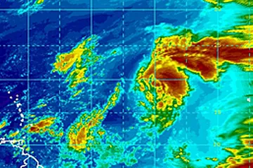
Tropical Depression 15 formed Wednesday midday, Oct. 3, 2012 from a tropical wave about half way between Africa and the Lesser Antilles.
According to Expert Senior Meteorologist Dan Kottlowski, head of the AccuWeather.com Hurricane Center, "We expect the system to strengthen to a tropical storm over the next couple of days."
The same large, non-tropical storm moving over the Atlantic that will pick up and bring Nadine's reign to an end is also forecast to scoop up the new depression.
(Image credit: AccuWeather.com)
The system is likely to turn toward the north and then the northeast, avoiding the Leeward and Windward Islands.
There is a chance this system or its remnants could pass close to the Azores next week.
Sign up for the Live Science daily newsletter now
Get the world’s most fascinating discoveries delivered straight to your inbox.
Giant, Non-Tropical Storm Forming
The large, non-tropical storm moving into position over the Atlantic could make for rough seas over much of the basin as it spins up to its full potential this weekend.
The system was organizing, growing and moving southeastward off of Newfoundland, Canada this week.
(Image credit: AccuWeather.com)
The circulation around the monster storm could grow to encompass over 2 million square miles (1,500 by 1,500 miles).
"It is not highly unusual to see big storms like this form over the oceans and it is certainly the time of the year for it," Kottlowski said.
Storms like this may not be as intense as a hurricane, but can bring tropical storm-like winds, rain and rough seas over a much-broader area.
The system itself could bring more rough conditions to the Azores than Nadine did the first time and the second time, as well as any impact from Tropical Depression 15.
The non-tropical storm could eventually extend impact in the form of gusty winds and areas of heavy rain to the United Kingdom and part of Europe, before diminishing during week two of October.
The storm will be centered farther east and will not be as intense as 1991's Halloween Nor'easter, also known as the "Perfect Storm."
This GOES satellite image of the "Perfect Storm" was taken on October 30, 1991.
(Image credit: AccuWeather.com)
That system absorbed energy from Hurricane Grace and turned into a real monster along the Atlantic Coast of North America with powerful winds, rough seas and coastal flooding lasting nearly a week.

 Live Science Plus