


Monster Typhoon Jelawat Eyes Philippines, Taiwan
This article was provided by AccuWeather.com.
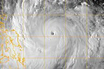
Typhoon Jelawat is currently churning across the Philippines Sea. Jelawat became a dangerous storm over the weekend with a perfectly symmetrical circulation and clear, well-defined eye. The storm underwent explosive intensification, almost doubling strength over the course of 12 hours.
Jelawat remains over very favorable ocean temperatures, and is in an area of little to no wind shear. These conditions will allow Jelawat to continue to strengthen early this week, and the storm may reach near super-typhoon strength.
Despite being hundreds of miles away from the Philippines, the system has already brought gusty thunderstorms and drenching rains to the eastern-half of the islands.
As the system drifts north and eastward, it will bring the potential to bring major impacts to the islands. While a direct landfall is not currently forecast, the system's proximity to Luzon could still lead to serious impacts.
Heavy and gusty showers and thunderstorms are expected to bombard the island for days to come. Due to the mountainous terrain of Luzon and much of the Philippines, extreme rainfall amounts and flooding are possible as the mountains act to wring out as much moisture as possible.
With some places quite possibly receiving up to a foot or more of rainfall, flash floods, mudslides and other dangerous weather will be possible. Later this week, when the storm passes close to Luzon, damaging winds, rough surf and rip currents are all possible.
Get the world’s most fascinating discoveries delivered straight to your inbox.
At this time, the AccuWeather.com Hurricane Center is forecasting Jelawat to pass east of Luzon, on a northward path generally near Taiwan.
Stay tuned to AccuWeather.com for all the latest on the tropics, and for all your weather needs.
© AccuWeather.com. All rights reserved. More from AccuWeather.com.