
 Live Science Plus


In Pictures: Japan Earthquake & Tsunami
Fukushima Nuclear Plant
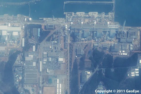
This half-meter resolution satellite image was taken of the Fukushima Daiichi nuclear power plant three days after a 9.0 magnitude earthquake struck the Oshika Peninsula on March 11, 2011.The image was taken by the GeoEye-1 satellite from 423 miles in space as it moved from north to south over Japan at a speed of four miles per second.
Damage in Rikuzentakata, Japan
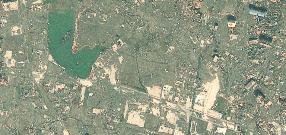
This half-meter resolution satellite image of Rikuzentakata, Japan, was taken two days after an 9.0-magnitude earthquake struck the Oshika Peninsula on March 11, 2011. Here you can see extensive destruction to buildings, vehicles and infrastructure. Entire regions have been flooded, swept away or reduced to ruin. The image was taken by the GeoEye-1 satellite at 10:21 a.m. (local time) on March 13, 2011, from 423 miles in space as it moved from north to south over Japan at a speed of 4 miles per second.
Fukushima Daiichi Nuclear Reactors
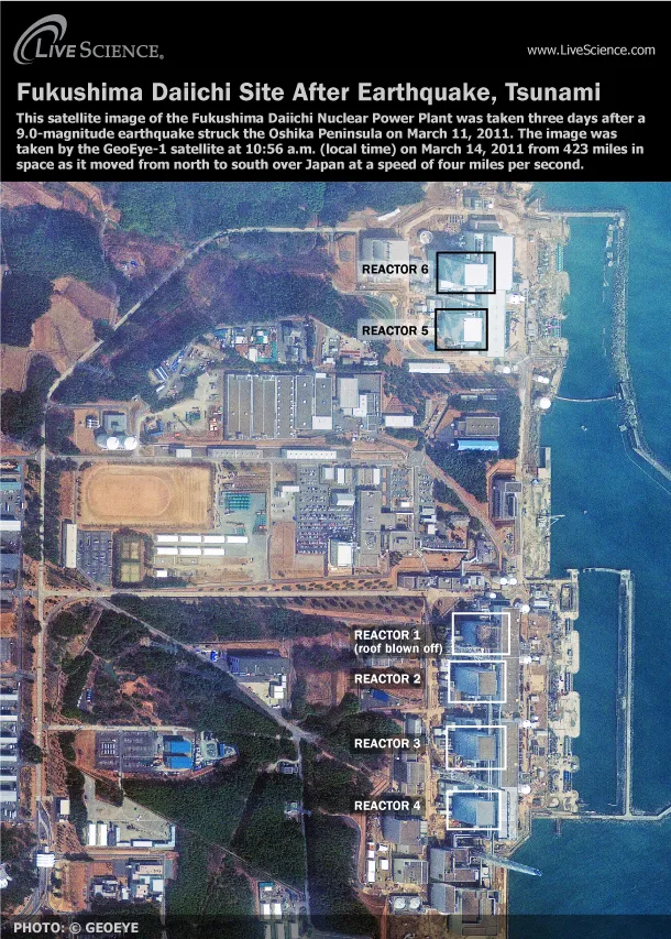
This GeoEye satellite image shows the nuclear reactors (labeled) at the Fukushima Daiichi plant after the earthquake and tsunami hit northeastern Japan.

Dog Sticks by Injured Friend

This still image was taken from a video of a dog in Sendai, Japan, that remained with an injured fellow canine. (See the video)
Japan power losses

One of the consequences of the massive earthquake and tsunami that struck northeastern Japan on March 11 was the widespread loss of electricity. Multiple areas along the coast experienced power losses, particularly around the city of Sendai. On March 12, 2011, satellite F-18 of the U.S. Air Force Defense Meteorological Satellite Program (DMSP) observed electricity losses in parts of northeastern Japan.
This composite image compares observations after the earthquake to images of lights observed in 2010. Yellow indicates lights that were functioning in both 2010 and 2011, and includes Tokyo and areas to the south and west. Red indicates power outages detected on March 12, 2011, compared with data from 2010. Areas of power loss include Sendai, and coastal locations north of Tokyo. Blue indicates clouds; Magenta indicates lights obscured by clouds. Bright green spots also may indicate new lights detected in 2011 that were not observed in 2010.
Get the world’s most fascinating discoveries delivered straight to your inbox.
Jeanna Bryner is managing editor of Scientific American. Previously she was editor in chief of Live Science and, prior to that, an editor at Scholastic's Science World magazine. Bryner has an English degree from Salisbury University, a master's degree in biogeochemistry and environmental sciences from the University of Maryland and a graduate science journalism degree from New York University. She has worked as a biologist in Florida, where she monitored wetlands and did field surveys for endangered species, including the gorgeous Florida Scrub Jay. She also received an ocean sciences journalism fellowship from the Woods Hole Oceanographic Institution. She is a firm believer that science is for everyone and that just about everything can be viewed through the lens of science.