 Live Science Plus


You are now subscribed
Your newsletter sign-up was successful
Want to add more newsletters?

Delivered Daily
Daily Newsletter
Sign up for the latest discoveries, groundbreaking research and fascinating breakthroughs that impact you and the wider world direct to your inbox.

Once a week
Life's Little Mysteries
Feed your curiosity with an exclusive mystery every week, solved with science and delivered direct to your inbox before it's seen anywhere else.

Once a week
How It Works
Sign up to our free science & technology newsletter for your weekly fix of fascinating articles, quick quizzes, amazing images, and more

Delivered daily
Space.com Newsletter
Breaking space news, the latest updates on rocket launches, skywatching events and more!

Once a month
Watch This Space
Sign up to our monthly entertainment newsletter to keep up with all our coverage of the latest sci-fi and space movies, tv shows, games and books.

Once a week
Night Sky This Week
Discover this week's must-see night sky events, moon phases, and stunning astrophotos. Sign up for our skywatching newsletter and explore the universe with us!
Join the club
Get full access to premium articles, exclusive features and a growing list of member rewards.
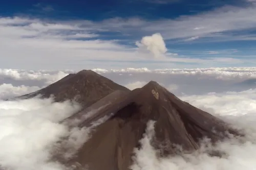
Drones can do more than capture high-flying footage, and researchers recently put the unmanned vehicles to work studying a volcano as it erupted.
During a research trip to Guatemala, a team of volcanologists and engineers used customized drones (also known as unmanned aerial vehicles, or UAVs) to investigate Volcán de Fuego.
Fuego is known for its near constant low-level activity, with smoke escaping from its top daily. However, the summit vent is difficult to access — the volcano has an elevation of 12,346 feet (3,763 meters) — and scientists have not been able to collect accurate gas measurements. [5 Surprising Ways Drones Could Be Used in the Future]
Using drones outfitted with a range of sensors, researchers were able to collect data directly from the volcano's ash clouds.
"These sensors not only help to understand emissions from volcanoes, they could also be used in the future to help alert local communities of impending eruptions – particularly if the flights can be automated," Emma Liu, a volcanologist from the University of Cambridge, said in a statement.
The researchers flew the drones beyond their visual line-of-sight, up to an altitude of 10,000 feet (3,048 m) and nearly 5 miles (8 kilometers) away, into the volcano's ash clouds. A so-called multiGAS sensor gathered data on carbon dioxide, sulfur dioxide and hydrogen sulfide, and another sensor collected samples of the ash. The drones also had thermal and visual cameras attached to observe the volcanic activity.
While these initial flights served as a proof-of-concept, the drones have already provided the researchers with new information about the volcano. For instance, the drones captured Fuego's changing summit topography. This showed the scientists that the volcano is erupting from two vents and not one, as was previously thought.
"Initial analysis of the sensor and flight data tell us that we will be able to automatically identify when we are in volcanic emissions," said Ben Schellenberg, a first-year doctoral student in aerospace engineering at the University of Bristol in the United Kingdom.
"I can’t wait to return to test out this hypothesis," he said.
Original article on Live Science.

