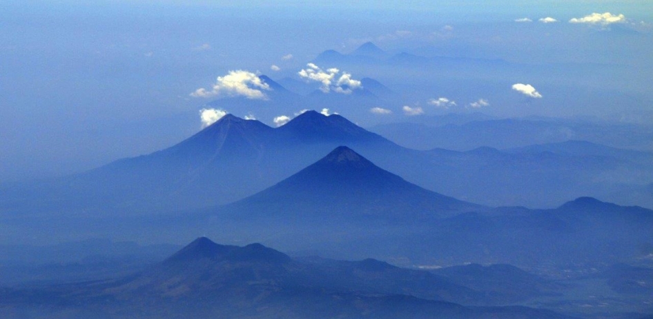
Active Guatemala Volcanoes Seen From Above (Photo)

Get the world’s most fascinating discoveries delivered straight to your inbox.
You are now subscribed
Your newsletter sign-up was successful
Want to add more newsletters?

Delivered Daily
Daily Newsletter
Sign up for the latest discoveries, groundbreaking research and fascinating breakthroughs that impact you and the wider world direct to your inbox.

Once a week
Life's Little Mysteries
Feed your curiosity with an exclusive mystery every week, solved with science and delivered direct to your inbox before it's seen anywhere else.

Once a week
How It Works
Sign up to our free science & technology newsletter for your weekly fix of fascinating articles, quick quizzes, amazing images, and more

Delivered daily
Space.com Newsletter
Breaking space news, the latest updates on rocket launches, skywatching events and more!

Once a month
Watch This Space
Sign up to our monthly entertainment newsletter to keep up with all our coverage of the latest sci-fi and space movies, tv shows, games and books.

Once a week
Night Sky This Week
Discover this week's must-see night sky events, moon phases, and stunning astrophotos. Sign up for our skywatching newsletter and explore the universe with us!
Join the club
Get full access to premium articles, exclusive features and a growing list of member rewards.
A four-week earth science mission to Guatemala brought back research on ground deformation in this active region — and a gorgeous shot of volcanoes upon volcanoes.
The stunning volcano image was taken from NASA's C20-A aircraft during an ongoing mission to 10 locations, including the volcanoes of Central and South America. The modified Gulfstream III is carrying an instrument called the Uninhabited Aerial Vehicle Synthetic Aperture Radar, according to NASA.
The radar-imaging mission is hitting several research hotspots, including the Gulf Coast of the United States. The goal is to provide data on everything from land deformation near volcanoes, which can indicate imminent activity, to vegetation data in forested areas. Other features under scrutiny are levees and glaciers. [Amazing Images of Volcanoes from Space]
All of the volcanoes in this image are active. The conical volcano in the middle of this image is Volcán de Agua, a 11,500-foot-tall (3,500 meters) mountain that sits a few miles from Antigua, Guatemala, a city of about 35,000 people and a UNESCO World Heritage site. The volcano gets its name from a lahar, or mudflow, that occurred in 1541, because of the watery flood associated with this event.
Behind Volcán de Agua are two peaks. The one on the right is Volcán de Fuego — the Volcano of Fire, which smolders at a low level almost daily. The last large belch from the volcano occurred in September 2012, leading to the evacuation of more than 30,000 people from nearby villages.
Next to Volcán de Fuego is Acatenango, which erupted in the 1920s and again in 1972, though those eruptions did not involve explosive ejections of ash and lava. The last explosive eruption of the volcano was about 1,900 years ago.
Finally, the stocky-looking volcano in the foreground is Volcán de Pacaya, which sent ash flying nearly 2 miles (3 kilometers) into the atmosphere on March 2, according to the Eruptions blog on Wired.com. The slopes of the volcano are home to Pacaya National Park, a popular tourist attraction.
Get the world’s most fascinating discoveries delivered straight to your inbox.
Follow Stephanie Pappas on Twitter and Google+. Follow us @livescience, Facebook & Google+. Original article on Live Science.

Stephanie Pappas is a contributing writer for Live Science, covering topics ranging from geoscience to archaeology to the human brain and behavior. She was previously a senior writer for Live Science but is now a freelancer based in Denver, Colorado, and regularly contributes to Scientific American and The Monitor, the monthly magazine of the American Psychological Association. Stephanie received a bachelor's degree in psychology from the University of South Carolina and a graduate certificate in science communication from the University of California, Santa Cruz.
 Live Science Plus


