
 Live Science Plus


A subterranean ramp that is part of a major fault in the Himalayas may push up the earth after major earthquakes, new research has found.
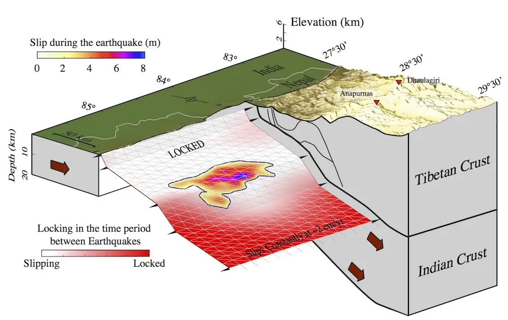
The new study mapped the fault line where the Indian Plate is diving beneath the Eurasian Continental Plate, which snakes across Tibet and Nepal. The fault is kinked, with one steeply diving "ramp" pushing up material that forms the world's tallest mountains, the scientists found.
The new study also corroborated other research that showed that the April 2015 Gorkha earthquake, which killed at least 8,000 people and injured thousands more, did not even come close to releasing all the stress on the fault. [See Photos of This Millennium's Destructive Earthquakes]

The earthquake was a magnitude 7.8, said study co-author Romain Jolivet, a geologist at the École Normale Supérieure in Paris. "It did a lot of damage and killed a lot of people, but it could have been bigger," Jolivet said.
Mysterious geometry
The tools typically used to analyze a fault, such as GPS and satellites, reveal how much faults are moving against one another over time. Geologists can also look at historical records in the rock to reveal long-term trends in the area.
For instance, the Himalayas have been rising by about 0.15 inches (4 millimeters) per year for millions of years, as a result of the Indian Plate smashing into the Eurasian Plate. Some of that stress translates to the uplift that has formed the world's highest mountain range, while the rest of the stress is released through violent earthquakes. But exactly how much goes into each phenomenon remains unknown, Jolivet said. Changes in the sediments in the region reveal that the fault between the two plates slips about 0.8 inches (2 centimeters) per year, he added.
Get the world’s most fascinating discoveries delivered straight to your inbox.
In the long term, sediments can reveal trends in the fault behavior, and in the short term, geologists can measure the motion of the fault using GPS. But when the faults are locked together and do not slip, geologists don't know exactly what's going on with a fault, Jolivet said.
In the wake of major earthquakes, however, geologists get a rare chance to analyze the underlying fault geometry, which can help researchers make predictions about future quakes in the region. For instance, a very flat fault tends to spread an earthquake much farther, whereas "if you have kinks and bends and faults branching with each other and things like that, it's harder to propagate, so you will tend to have multiple small earthquakes," Jolivet told Live Science.
Big shifts, more to come
So, when the magnitude-7.8 temblor struck Nepal on April 25, 2015, Jolivet and his colleagues began analyzing satellite images and GPS data from the quake, comparing before and after images to create a snapshot of the underlying fault geometry.
The team found that the earthquake shifted Kathmandu 5 feet (1.5 meters) to the south and pushed it up by almost 24 inches (60 cm).
"That's quite a lot," Jolivet said. (The quake also caused Mount Everest to shrink by about 1 inch (2.5 cm), other research found.)
Like other groups, the team also found that the Gorkha earthquake did not release all the stress on the fault at the surface, with the fault's rupture stopping about 7 miles (11 kilometers) below the surface under Kathmandu. This pent-up energy means big earthquakes in the region could potentially happen sooner than one would otherwise expect, Jolivet said.
By comparing the slip rates they found at different locations, the researchers also recreated the underlying fault geometry. They found that most of the slip occurred on a very flat, shallow portion of the fault, but that farther north, the fault kinks, dipping into the Earth at a much steeper, 20- to 30-degree angle, Jolivet said.
Someone who was riding this fault would start out at the surface in India, slide steeply down into the Earth beneath Nepal for a few miles, and then reach a wide, flat portion of the fault that dips more gently. From there, another steep ramp dips down until the fault is roughly 16 miles (25 km) below the surface. The angle of the fault then becomes shallower to accommodate the Indian Plate's dive beneath Tibet, Jolivet said. The steep ramp, which is about 12 miles (20 km) below the surface, shoves material upward, growing the mountains over time, the study found.
A better understanding of the fault geometry could eventually help researchers figure out exactly how the Himalayas grow over the long term, Jolivet said. For instance, data from the past decade suggest that the plate collision causes shortening that roughly equals the slip on the fault over the past several thousand years. That leaves the question of what is left to cause the Himalayas to grow, he said.
The findings were published Jan. 11 in the journal Nature Geoscience.
Follow Tia Ghose on Twitter and Google+. Follow Live Science @livescience, Facebook & Google+. Original article on Live Science.

Tia is the editor-in-chief (premium) and was formerly managing editor and senior writer for Live Science. Her work has appeared in Scientific American, Wired.com, Science News and other outlets. She holds a master's degree in bioengineering from the University of Washington, a graduate certificate in science writing from UC Santa Cruz and a bachelor's degree in mechanical engineering from the University of Texas at Austin. Tia was part of a team at the Milwaukee Journal Sentinel that published the Empty Cradles series on preterm births, which won multiple awards, including the 2012 Casey Medal for Meritorious Journalism.