
 Live Science Plus


How Did the Tibetan Plateau Form?

It's called the "Roof of the World" with good reason the Tibetan Plateau stands over 3 miles above sea level and is surrounded by imposing mountain ranges that harbor the world's two highest summits, Mount Everest and K2. For comparison, the tallest mountain in the contiguous United States is Mount Whitney, located in California, which is 14,505 feet (4,421 meters) high.
While the world's top mountaineers regularly attempt to summit the forbidding peaks of the Tibetan Plateau, the remote area is home to a rich variety of cultures, from villages in Pakistan that practice the various sects of Islam to the Buddhist communities of Tibet, now part of the People's Republic of China. Perhaps the most well-known person of the region is the Dalai Lama, Tibet's spiritual leader and an advocate for a peaceful solution to Tibet's bid for independence.

The geologic tale, as it has been known, is familiar to many schoolchildren: About 50 million years ago, the Indian subcontinent began to collide with Eurasia, and as it slammed into the bigger landmass, the plateau and the Karakoram and Himalaya ranges were born.
But there's more to the story.
In a review of research on the evolution of the Tibetan Plateau, published in the Aug. 22, 2008 issue of the journal Science and funded by the National Science Foundation, a group of researchers put together the geological puzzle pieces to develop a more intricate, and somewhat controversial, picture of the development of the modern Tibetan Plateau than was previously envisioned.
"It's a complicated place," said Leigh Royden of MIT, lead author of the review.
Putting the pieces together could also help scientists determine the cause of the earthquake that rocked the southern Qinghai province in China, which is part of the Tibetan Plateau. The quake occurred early in the morning on April 14, 2010 and caused at least 400 deaths, according to current estimates from news reports.
This earthquake was different than some of the major temblors that have struck around the world so far this year in that it occurred in the middle of one of Earth's tectonic plates, instead of at the junction between them.
Continents collide
Before India rammed into Eurasia, the Tethys Ocean, which separated the two landmasses, was being subducted beneath Eurasia. In the Late Cretaceous (about 100 to 65 million years ago) a volcanic mountain range similar to the modern Andes developed along the southern edge of the Eurasian plate. But these earlier mountains would have been "nothing like what's there now," Royden said.
These earlier tectonics would have begun to raise portions of the Tibetan Plateau above sea level and thickened the continental crust there, the researchers said, setting the stage for what would come later.
After the collision, more of the area now included in the plateau was involved in the tectonic changes, with the southern and central portions of Tibet reaching high elevations (the northern portions remained low) as the crust "shortened," or smushed together. As the crust was mashed, the towering peaks that make up the Himalayas and the Karakoram were gradually pushed up to their dizzying heights.
As the collision progressed, material from the lithosphere (the solid outer shell of the planet) below the surface crust was "shoved out" toward the east, as Royden put it. These lozenges of lithosphere were aided by the eastward movement of subduction trenches in the Pacific Ocean to the east of what is now China.
Crustal movement
Eventually, around 20 millions years ago, the trenches halted in their eastward march. As India and Eurasia continued to collide, "stuff couldn't leave to the east," Royden explained.
While some geologists think crustal shortening continued to build up the eastern plateau, Royden says there is little evidence for this, and that the pile-up of lithospheric material underneath the plateau continued to thicken the crust and raise the eastern portion of the plateau.
Whether or not the subsurface material is flowing faster or slower now, geologists aren't sure, Royden said. By extension, they don't know whether the plateau is getting higher or lower, though that may depend on what part of the plateau you're talking about, Royden said, with some parts possibly rising while others sink. Studies of the rates at which rivers have cut down through the rock in these areas may help geologists to suss out the vertical motions of the plateau.
Tibet and the Sichuan quake
The movement of the lithosphere under the plateau could also be behind the devastating earthquake that occurred in Sichuan, China in 2008, Royden said.
The area where the quake occurred is traditionally considered one of low seismic risk, Royden said. Some geologists have said the quake was a result of traditional thrust faulting, where one piece of crust is pushed up over another. But, "when you look at the whole geologic context," Royden says, the vertical uplift of the lithosphere in the region could be at fault.
As the material flows eastward it runs into an older, stronger piece of crust at the Sichuan Basin and piles up at the basin's western edge. The interpretation of Royden and her colleagues is that a fault with vertical and eastward motion set up by this situation created the quake.
Though much about the Tibetan Plateau's geology, including the exact causes of the Sichuan and Qinghai quakes, remain a mystery, Royden is fairly certain than in a decade or two, geologists will have a much clearer picture of what is happening underneath the "Roof of the World."
- What Was Different About China's Quake?
- Natural Disasters: Top 10 U.S. Threats
- 13 Crazy Earthquake Facts
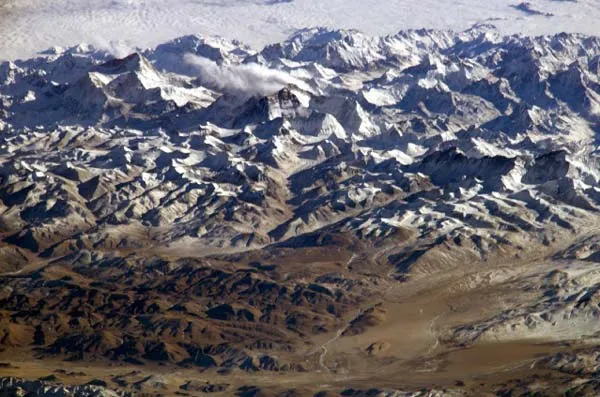
More about the photo above: Mt. Everest and Makalu was taken by an Expedition 8 crewmember on the International Space Station (ISS). Crewmembers on board the Station have a unique view of the world because of their position in a low orbit (200 nautical miles, 360 kilometers) relative to satellites and their ability to look at any angle out the windows of the spacecraft. ISS crewmembers recently took advantage of their vantage point to photograph this oblique view of the Himalayas looking south from over the Tibetan Plateau. At first glance, one might think that the image looks like a picture taken from an airplane; until you remember that the summits of Makalu [left (8,462 meters: 27,765 feet)] and Everest [right (8,850 meters; 29,035 feet)] are at the heights typically flown by commercial aircraft, and could never be seen this way from an airplane.
