
 Live Science Plus


First-of-its-kind video captures the terrifying moment the ground tore apart during major Myanmar earthquake
A security camera near Thazi, Myanmar, captured the earth cracking during a magnitude 7.7 earthquake in March.

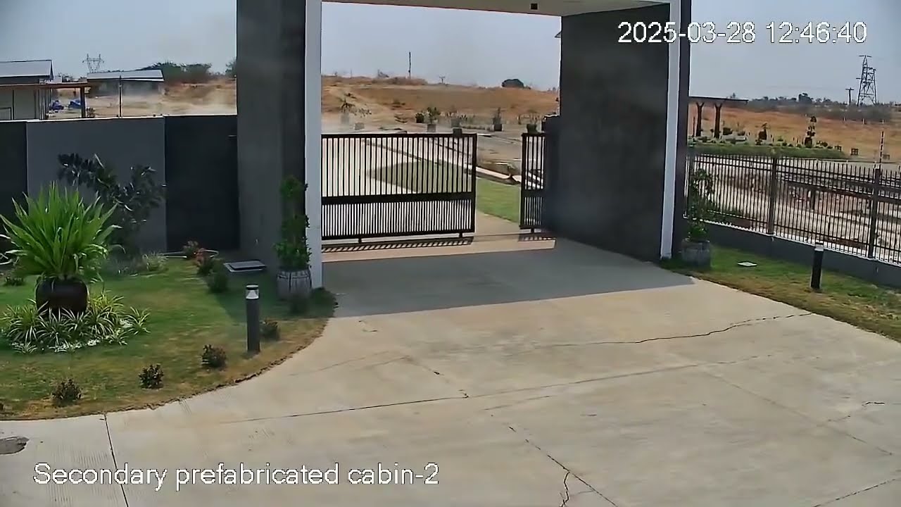
A video showing the ground tearing apart in a major earthquake in Myanmar in March may be the first of its kind.
The video captures a ground rupture, the ripping of Earth's crust all the way up to the surface, during a major earthquake. The magnitude 7.7 quake struck on March 28 at 12:50 p.m. local time and was felt as far away as Thailand. Nearly 5,500 people died.
The video, posted on Facebook by Singaporean engineer Htin Aung, comes from GP Energy Myanmar's Thapyawa solar farm, located near the town of Thazi, according to Aung's post. The feed is centered on a concrete-and-metal gate, which shudders and slides open as the earth begins to move. About 14 seconds into the video, a crack opens across the driveway and yard outside the gate, with the ground literally pulling apart.
"It's really kind of unsettling," said John Vidale, a seismologist at the University of Southern California Dornsife. Vidale told Live Science he knew of no other videos that show such a ground rupture. Rick Aster, a geophysicist at Colorado State University, concurred.
"To my knowledge, this is the best video we have of a throughgoing surface rupture of a very large earthquake," Aster told Live Science.
The Myanmar quake occurred on the Sagaing Fault between the Burma and Sunda tectonic plates, two minor tectonic plates. This fault slices through central Myanmar in a straight line, north to south. It's a transform fault, just like California's famous San Andreas, where the two plates move side by side against each other.
The epicenter of the Myanmar quake, where the fault rupture started, was north of the location in the video, near the city of Mandalay. This rupture then propagated both north and south, cracking the ground all along the fault line.
Get the world’s most fascinating discoveries delivered straight to your inbox.
"The actual segment of the Earth that is slipping side to side goes from the surface down to maybe 20 or 30 kilometers [12 to 19 miles] depth," Aster said. Below that, the crust still moves, but the crust is more malleable and deforms rather than cracks.
The shaking first seen in the video comes from the earthquake waves that speed out from the rupturing crack, Vidale said. Then, the rupture itself arrives.
RELATED STORIES
Seismologists get good measurements of such ruptures from seismic stations that use GPS to quantify even tiny movements of the crust. They also often do fieldwork to find evidence of ruptures after they happen, Aster said. "But we don't really understand the dynamics of what happened, exactly how things move," he said. The video might be useful for researchers who are trying to understand those unusual dynamics.
"I have no doubt that seismologists will take a very close look at this," Aster said. "It will probably lead to some kind of a publication at some point, if the location and other details can be sorted out."
Live Science reached out to Aung and to GP Energy Myanmar and will update this story with further details, if available.

Stephanie Pappas is a contributing writer for Live Science, covering topics ranging from geoscience to archaeology to the human brain and behavior. She was previously a senior writer for Live Science but is now a freelancer based in Denver, Colorado, and regularly contributes to Scientific American and The Monitor, the monthly magazine of the American Psychological Association. Stephanie received a bachelor's degree in psychology from the University of South Carolina and a graduate certificate in science communication from the University of California, Santa Cruz.
You must confirm your public display name before commenting
Please logout and then login again, you will then be prompted to enter your display name.