 Live Science Plus


September Was Warmest on Record, NASA Data Shows
You are now subscribed
Your newsletter sign-up was successful
Want to add more newsletters?

Delivered Daily
Daily Newsletter
Sign up for the latest discoveries, groundbreaking research and fascinating breakthroughs that impact you and the wider world direct to your inbox.

Once a week
Life's Little Mysteries
Feed your curiosity with an exclusive mystery every week, solved with science and delivered direct to your inbox before it's seen anywhere else.

Once a week
How It Works
Sign up to our free science & technology newsletter for your weekly fix of fascinating articles, quick quizzes, amazing images, and more

Delivered daily
Space.com Newsletter
Breaking space news, the latest updates on rocket launches, skywatching events and more!

Once a month
Watch This Space
Sign up to our monthly entertainment newsletter to keep up with all our coverage of the latest sci-fi and space movies, tv shows, games and books.

Once a week
Night Sky This Week
Discover this week's must-see night sky events, moon phases, and stunning astrophotos. Sign up for our skywatching newsletter and explore the universe with us!
Join the club
Get full access to premium articles, exclusive features and a growing list of member rewards.
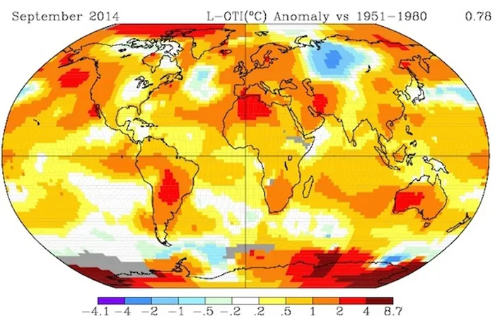
Like August before it, September 2014 was the warmest September on record, according to newly updated NASA data. The warm month makes it even more likely that 2014 will become the warmest year on record.
This September was about 1.4°F above the 1951-1980 average temperature for the month, data from NASA’s Goddard Institute for Space Studies (GISS) showed. That makes it the warmest September in GISS records, edging out the previous September record set in 2005. GISS records extend back to 1880.
September followed what both NASA and the National Climatic Data Center (NCDC) rated as the warmest August on record, and what NASA ranked as the fourth warmest summer on record globally. NCDC’s temperature data for September will be released later this week.
2014 on Track to be Hottest Year on Record New CO2 Milestone: 3 Months Above 400 PPM Planet is Running a Temp: State of the Climate 'Check-Up'
When August’s record-breaking warmth was announced, Jake Crouch, an NCDC climatologist, said, “if we continue a consistent departure from average for the rest of 2014, we will edge out 2010 as the warmest year on record.” For that to happen, each of the remaining months of the year would only have to rank among the top five warmest, he added.
With the NASA data suggesting September easily met that mark, it becomes more likely that 2014 will take the top slot.
Ocean temperatures have played a large role in 2014’s warmth, including the warmer-than-normal sea surface temperatures in the tropical Pacific Ocean that have accompanied an emerging El Niño, Kevin Trenberth, a climatologist with the National Center for Atmospheric Research, told Climate Central in an email.
The ocean is where some 90 percent of the excess heat trapped by greenhouse gases is stored.
Of the five warmest years on record (2010, 2005, 1998, 2013, and 2003, in that order), only 2013 and 2014 didn’t start with a mature El Niño, according to the National Oceanic and Atmospheric Administration, the parent organization of the NCDC.

The El Niño is still being given a two-thirds chance of forming before the year is out, which bolsters the likelihood that 2014 will become the warmest year in the books.
Gavin Schmidt, the NASA GISS director, has cautioned against trying to find larger-scale meaning in the exact records of specific months, as the difference between first and second place can be very small and natural variability plays a large role from month-to-month and year-to-year.
Instead, he told Climate Central last month, the important trend to watch is the overall long-term picture of warming, which the recent “run of warm months” feeds into.
You May Also Like: Where Is El Nino? And Why Do We Care? 2014 Extreme Weather: What Attribution Can Tell Us The $9.7 Trillion Problem: Cyclones and Climate Change Oceans Getting Hotter Than Anybody Realized
Follow the author on Twitter @AndreaTWeather or @ClimateCentral. We're also on Facebook & other social networks. Originally published on Climate Central.

