

Swirling supercell thunderstorms brewed over the border between North and South Carolina in May, showering the area with chunks of hail as big as baseballs.
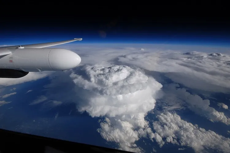
The huge storm column stretched 50,000 feet (15,000 meters) tall. NASA's Earth Observatory recently released a photo that a pilot took as he flew an ER-2 aircraft over the storms on May 23. Normal commercial airplanes fly at around 30,000 feet (9,000 m), but the ER-2 soared around 65,000 feet (20,000 m).
An anvil-shaped cloud typically forms in a thunderstorm when cooler winds push warm air up into the atmosphere, and a particularly powerful updraft can produce a huge dome-shaped cap called an "overshooting top." Severe storms, like the supercell in the photo, tend to have large and long-lasting overshooting tops. [Extreme Weather Facts: Quiz Yourself]
A spinning vortex of air called a mesocyclone lies at the heart of a supercell. When the mesocyclone interacts with strong updrafts, the storms can churn out tornadoes and produce destructive hailstorms. Most of the supercells over the Carolinas in May produced quarter-size hail, but some of the strongest storms rained down baseball-size pieces.
The ER-2 flight was part of a mission called the Integrated Precipitation and Hydrology Experiment (IPHEx) led by NASA, Duke University and the National Oceanic and Atmospheric Administration (NOAA) that ran from May 1 to June 15. IPHEx was designed to evaluate the accuracy of satellite precipitation estimates compared to ground measurements. Researchers set up ground rain gauges and radar to measure true rainfall amounts. The team then compares the true precipitation measurements to about 95 hours' worth of precipitation data collected by satellites and two aircraft.
NASA hopes to use the data to create models to predict storm activity over the Appalachian Mountains and measure how much water remains in rivers and aquifers. The models could help direct water conservation efforts and help predict floods and landslides around the area's rivers.
IPHEx is part of a larger mission called Global Precipitation Project, a joint effort between NASA and Japan's Aerospace Exploration Agency to monitor global rainfall and snowfall. The mission uses a constellation of satellites that work together to record worldwide precipitation data every 2 to 3 hours. Scientists hope the data will reveal more about water cycle patterns around the world.
Follow Kelly Dickerson on Twitter. Follow us @livescience, Facebook & Google+. Original article on Live Science.

