Top 10 Earth Images from 2014
The best of our home
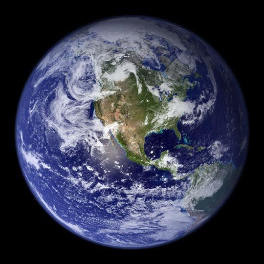
Each year, NASA's Earth Observatory runs its own March Madness contest,pitting the year's best Earth images in a head-to-head competition.Here are the top 10, as selected by popular vote.
The tournament winner: Trailing the Canaries
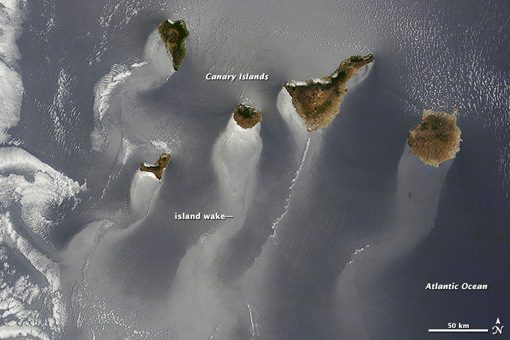
The play of light on water can reveal overlooked details and nuances to photographers and artists on Earth. The same thing can happen when looking from space. In the image above, wavy, windsock-like tails stretch to the southwest from each of the islands. The patterns are likely the result of winds roughening or smoothing the water surface in different places. Prevailing winds in the area come from the northeast, and the rocky, volcanic islands create a sort of wind shadow—blocking, slowing, and redirecting the air flow. That wind, or lack of it, piles up waves and choppy water in some places and calms the surface in others, changing how light is reflected. Ocean currents, oil or pollution slicks, and internal waves can also alter surface patterns, though none are necessarily visible in this image. According to sailors’ guides to the area, winds on the leeward side of the Canary Islands often blow in the opposite direction of the prevailing winds. The play of land and wind can also create a funnel effect, speeding up air flow around the coasts. The swirling nature of the leeward wind field is shown in a long, helical trail of clouds stretching southwest from Tenerife (the second island from the right).
Long-term global warming trend continues
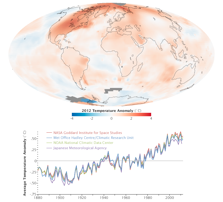
Scientists at NASA’s Goddard Institute for Space Studies (GISS) say 2012 was the ninth warmest year since 1880, continuing a long-term trend of rising global temperatures. The ten warmest years in the 132-year record have all occurred since 1998. The last year that was cooler than average was 1976.
Snow across Great Britain
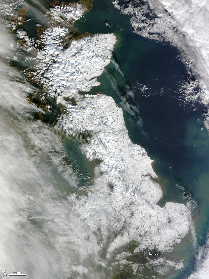
Snow blanketed most of Great Britain in late January 2013, stretching from London to the northern tip of Scotland. Only some coastal areas and the southwestern part of the island were free of snow when MODIS took this picture. Skies had mostly cleared by the time MODIS acquired the image, but some clouds lingered in the west, casting shadows onto the snowy surface below. On January 25, The Telegraph reported that the death toll from the storm was in the double digits, some of the deaths resulting from hazardous driving conditions.
Tristan da Cunha, South Atlantic Ocean
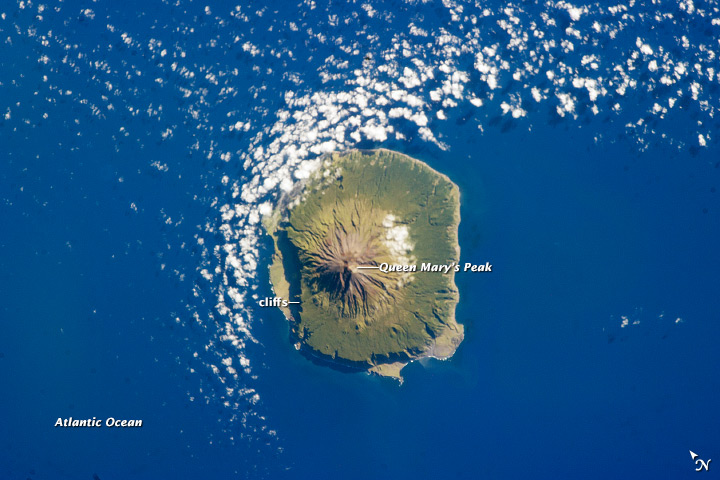
The island of Tristan da Cunha is located in the southern Atlantic Ocean—more than 3,700 kilometers (2,300 miles) from the coastline of Antarctica, approximately 2,800 kilometers (1,700 miles) to the southern tip of Africa, and more than 3,000 kilometers (1,900 miles) from the east coast of South America. Tristan da Cunha is a shield volcano, a volcanic structure with a low, broad profile and composed of silica-poor lavas (such as basalt). The upper surface of this low base appears dark green in this astronaut photograph. Steeper brown to tan colored slopes mark the central cone of the volcano at the island’s center. The summit crater, Queen Mary’s Peak, sits at an elevation of 2,060 meters (6,760 feet) above sea level. While geologic evidence indicates that eruptions have occurred from the central crater, lavas have also erupted from flank vents along the sides of the volcano and from smaller cinder cones.
Rare clear view of Alaska
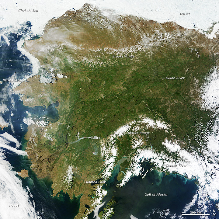
On most days, relentless rivers of clouds wash over Alaska, obscuring most of the state’s 6,640 miles (10,690 kilometers) of coastline and 586,000 square miles (1,518,000 square kilometers) of land. That was certainly not the case on June 17, 2013, the date that the Moderate Resolution Imaging Spectroradiometer (MODIS) on NASA’s Terra satellite acquired this rare, nearly cloud-free view of the state. The absence of clouds exposed a striking tapestry of water, ice, land, forests, and even wildfires.Snow-covered mountains such as the Alaska Range and Chugach Mountains were visible in southern Alaska, while the arc of mountains that make up the Brooks Range dominated the northern part of the state. The Yukon River—the longest in Alaska and the third longest in the United States—wound its way through the green boreal forests that inhabit the interior of the state. Plumes of sediment and glacial flour poured into the Gulf of Alaska from the Copper River. And Iliamna Lake, the largest in Alaska, was ice free.
Major iceberg cracks off Pine Island Glacier
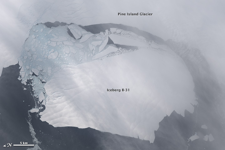
Between November 9–11, 2013, a large iceberg finally separated from the calving front of Antarctica’s Pine Island Glacier. Scientists first detected a rift in the glacier in October 2011 during flights for NASA’s Operation IceBridge. By July 2013, infrared and radar images indicated that the crack had cut completely across the ice shelf to the southwestern edge. New images now show that Iceberg B-31 is finally moving away from the coast, with open water between the iceberg and the edge of Pine Island Glacier. Named B-31 by the U.S. National Ice Center, the new iceberg is estimated to be 35 kilometers by 20 kilometers (21 by 12 miles), roughly the size of Singapore. A team of scientists from Sheffield and Southampton universities will track the 700 square-kilometer chunk of ice and try to predict its path using satellite data.
Get the world’s most fascinating discoveries delivered straight to your inbox.
Extensive ice fractures in the Beaufort Sea
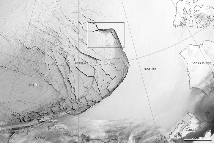
The Visible Infrared Imaging Radiometer Suite (VIIRS) on the Suomi NPP satellite captured this view of extensive sea-ice fracturing off the northern coast of Alaska. The event began in late-January and spread west toward Banks Island throughout February and March 2013. Visualizations of the Arctic often give the impression that the ice cap is a continuous sheet of stationary, floating ice. In fact, it is a collection of smaller pieces that constantly shift, crack, and grind against one another as they are jostled by winds and ocean currents. Especially during the summer—but even during the height of winter—cracks—or leads—open up between pieces of ice.
Mount Etna boils over
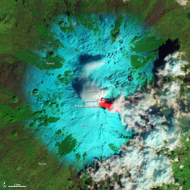
After maintaining a low simmer for ten months, Italy’s Etna volcano boiled over on February 19–20, 2013, with three outbursts in 36 hours. In the image, fresh lava is bright red, as the hot surface emits enough energy to saturate the instrument’s shortwave infrared detectors but is dark in near-infrared and green light. Snow is blue-green because it absorbs shortwave infrared light, but reflects near-infrared and green light. Clouds made of water droplets (not ice crystals) reflect all three wavelengths of light similarly and appear white. Forests and other vegetation reflect near-infrared more strongly than shortwave infrared and green, and so appear green. Dark gray areas are lightly vegetated lava flows, 30 to 350 years old.
A satellite's view of ship pollution
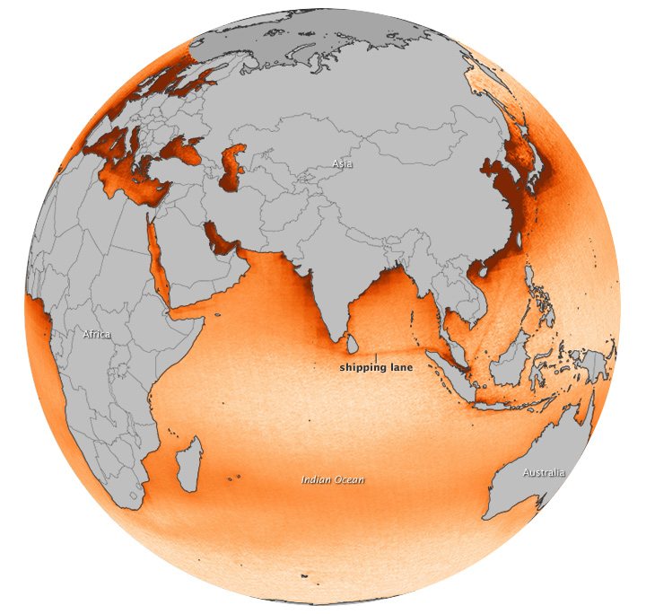
For more than a decade, scientists have observed “ship tracks” in natural-color satellite imagery of the ocean. These bright, linear trails amidst the cloud layers are created by particles and gases from ships. They are a visible manifestation of pollution from ship exhaust, and scientists can now see that ships have a more subtle, almost invisible, signature as well. The map above is based on OMI measurements acquired between 2005 and 2012. The NO2 signal is most prominent in an Indian Ocean shipping lane between Sri Lanka and Singapore, appearing as a distinct orange line against (lighter) background levels of NO2. Other shipping lanes that run through the Gulf of Aden, the Red Sea, and the Mediterranean Sea also show elevated NO2 levels, as do routes from Singapore to points in China. These aren’t the only busy shipping lanes in the world, but they are the most apparent because ship traffic is concentrated along narrow, well-established lanes.
Activity at Kliuchevskoi
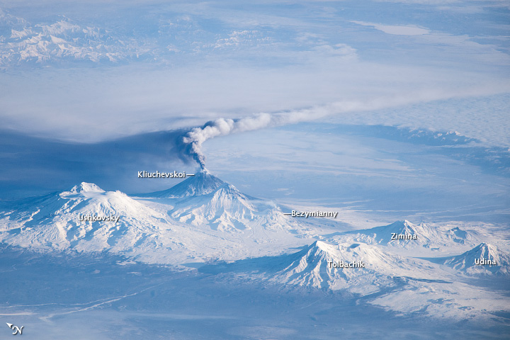
When viewing conditions are favorable, astronauts on the International Space Station (ISS) can take unusual and striking images of the Earth. This photograph provides a view of an eruption plume emanating from Kliuchevskoi, one of the many active volcanoes on the Kamchatka Peninsula. his photo was taken from the ISS with an oblique viewing angle that gives a strong sense of three dimensions, which are also accentuated by the shadows cast by the volcanic peaks. The result is a view similar to what you might see from a low-altitude airplane. The plume—likely a combination of steam, volcanic gases, and ash—stretched to the east-southeast due to prevailing winds. The dark region to the north-northwest is likely a product of shadows and of ash settling out. Several other volcanoes are visible in the image, including Ushkovsky, Tolbachik, Zimina, and Udina. To the south-southwest of Kliuchevskoi lies Bezymianny Volcano, which appears to be emitting a small steam plume (at image center).
 Live Science Plus


