It's quick and easy to access Live Science Plus, simply enter your email below. We'll send you a confirmation and sign you up for our daily newsletter, keeping you up to date with the latest science news.
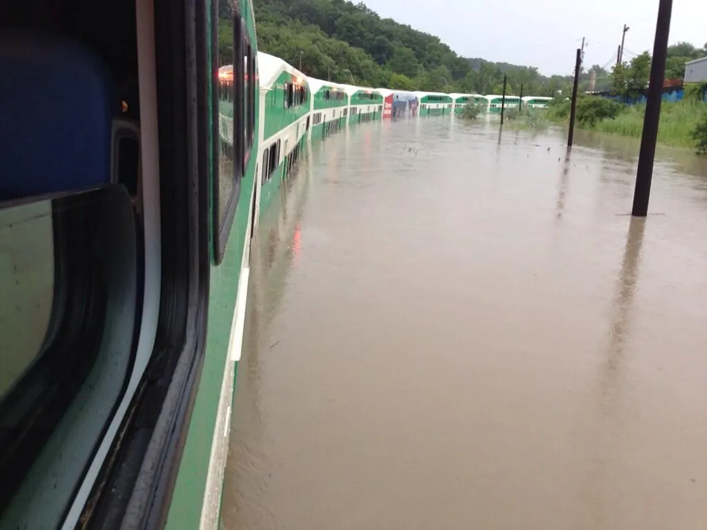
Severe thunderstorms and rain caused widespread flooding in Toronto, Canada, on July 8, 2013. This photo, taken from Toronto's commuter GO Train, shows the extend of the flooding.
The torrential rain that soaked parts of Toronto yesterday (July 8), causing widespread flooding on major highways and hobbling the city's transit system, broke Toronto's nearly 60-year-old single-day rainfall record, meteorologists said.
Nearly 4 inches (10 centimeters) of rain fell in just two hours yesterday in and around Toronto, triggering severe flash floods and stranding some commuter-train passengers for hours before police could rescue them in boats. At Toronto's Pearson International Airport, almost 5 inches (13 cm) of rain were recorded, which is more than the average rainfall the city typically receives for the entire month of July.
The heavy rain was generated by two separate storms that collided over the Greater Toronto area, a region that encompasses the city of Toronto and four surrounding regional municipalities.
"All that intense rainfall occurred when two thunderstorm complexes, one north of Toronto and one west of Toronto, merged," said Peter Kimbell, a warning preparedness meteorologist at Environment Canada. "The merger basically happened right over the airport and downtown area." [Video: Toronto Flash Floods Cause Traffic Chaos, Blackouts]
A lingering pattern of warm and humid air likely strengthened the storms as well, said Judy Levan, a warning coordination meteorologist at the U.S. National Weather Service in Buffalo, N.Y.
"We have a really rich stream of moisture coming up from the Gulf, so this pattern of air hasn't changed much," Levan told LiveScience. "That tends to make things worse, because you have these thunderstorms developing one day, and the next, and the next, so the soil becomes saturated and it can't even take as much rain."
This photo, taken by Colin Price, shows the severe flooding in Toronto, Canada, on July 8, 2013.
As the term suggests, flash floods occur suddenly and unexpectedly when a deluge of rain falls over a short period of time. This type of flooding typically occurs when a slow-moving storm passes over an area, or when multiple thunderstorms gather over the same region, according to the U.S. National Weather Service (NWS), which operates as part of the National Oceanic and Atmospheric Administration. The slow-moving systems cause rain to accumulate on the ground faster than the soil can absorb it, leading it to wash over the surrounding terrain, building up in low-lying areas. Storms that move quickly over an area are less likely to cause flash flooding because the heavy rainfall is distributed over more expansive areas.
Sign up for the Live Science daily newsletter now
Get the world’s most fascinating discoveries delivered straight to your inbox.
In the United States, flash floods are, on average, the top cause of weather-related deaths, according to the NWS, and almost half of all flash-flood fatalities happen when drivers in cars or trucks are swept away. Many vehicles, including city buses and a local commuter train, were engulfed in the Toronto floods.
Though topography can play a role in the severity of flash flooding, Toronto's storms likely garnered a lot of attention because the flooding occurred in the most densely populated part of Canada, Kimbell told LiveScience.
Still, yesterday's storms broke the city's long-standing record for the amount of rainfall measured in one day.
"The previous record was recorded during Hurricane Hazel, on Oct. 15, 1954," Kimbell said. "We haven't seen that amount of rain at the airport for the last 60 years or so. That being said, we do see significant storms that produce local flooding — and they'll continue to happen — but this one was just over an incredibly densely populated area."
Denise Chow was the assistant managing editor at Live Science before moving to NBC News as a science reporter, where she focuses on general science and climate change. Before joining the Live Science team in 2013, she spent two years as a staff writer for Space.com, writing about rocket launches and covering NASA's final three space shuttle missions. A Canadian transplant, Denise has a bachelor's degree from the University of Toronto, and a master's degree in journalism from New York University.

 Live Science Plus