It's quick and easy to access Live Science Plus, simply enter your email below. We'll send you a confirmation and sign you up for our daily newsletter, keeping you up to date with the latest science news.
Hurricane hunting aircraft have been flying Hurricane Irene for nearly a week, keeping close watch on the massive Category 2 storm that is barreling toward the U.S. coast, much of the Eastern Seaboard in its cross hairs.
At 4 a.m. this morning (Aug. 26) a hurricane-chasing P-3 turboprop plane took off from MacDill Air Force Base in Tampa, Fla., to monitor conditions inside the storm. The instrument-laden aircraft, operated by the National Oceanic and Atmospheric Administration (NOAA), spent a full 5 hours of the 7.5-hour flight crisscrossing through Hurricane Irene at an altitude of 8,000 feet (2,440 meters), and touched down just around noon today.
The onboard meteorologist, reached by phone an hour after the flight returned, said that, although most conditions inside powerful Hurricane Irene had held steady over the last several days, there was one change.
"Our first three flights we noticed the pressure was falling, so that was an indication that the storm was getting stronger," said A. Barry Damiano, a meteorologist flight director for NOAA. "And today, for most of our passes through the storm center, the pressure held steady, until the last pass," when the team noted a very slight rise in pressure, Damiano told OurAmazingPlanet.
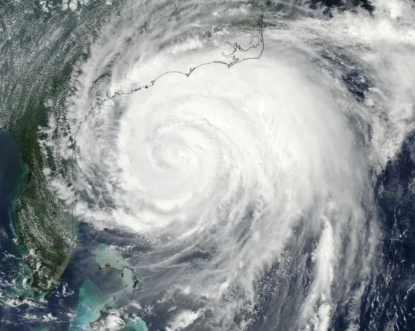
Hurricane Irene, snapped by a satellite on Friday, Aug. 26, as the massive storm blasted up the Atlantic coastline.
(Image credit: NASA.)
A hurricane's internal pressure is associated with its intensity, Damiano said. So although today's slight uptick in pressure does mark a change from the previous three days, when pressure had dropped steadily, Damiano said the turnaround is no cause for celebration.
"When the pressure falls, it gets stronger, when the pressure rises, it's getting weaker, but it doesn't happen at the drop of a hat," Damiano said. "We can't say it's really weakening."
Damiano said that Hurricane Irene remains a big threat. "It's a very large storm with a very large wind field," he said.
Sign up for the Live Science daily newsletter now
Get the world’s most fascinating discoveries delivered straight to your inbox.
The storm is packing winds of 100 mph (155 kph). Tropical storm-force winds, which can reach 74 mph (120 kph), extend nearly 300 miles (482 kilometers) from the center of the storm, which is now moving up the Atlantic coast off South Carolina at 14 mph (23 kph).
In addition to its wide reach, Damiano said Hurricane Irene is producing a lot of rain, "This is a very wet storm," he said.
Even if Hurricane Irene's winds die down slightly, flooding and storm surge are serious concerns for many areas that lie in the storm's path.
Two P-3s on the tarmac between missions into Hurricane Irene.
(Image credit: NOAA.)
"A lot of people are going to be impacted," Damiano said.
Paul Flaherty, chief flight meteorologist for NOAA's weather planes, agreed, noting that unlike some storms in the past, that may have hit a single area often with devastating results Hurricane Irene is marching straight up the Atlantic coastline, with many population centers in its path.
New York City has already announced that, because of the storm, it will shut down its subway system beginning at noon on Saturday. Flaherty said Hurricane Irene could take a serious toll on regions as far north as Rhode Island and eastern Massachusetts.
"That's what's amazing about this storm," Flaherty said. "Regardless of damage or destruction the massive amount of people affected is what's going to be remarkable about this storm."
Andrea Mustain was a staff writer for Live Science from 2010 to 2012. She holds a B.S. degree from Northwestern University and an M.S. degree in broadcast journalism from Columbia University.