
 Live Science Plus


Images: World's Snow Cover Seen from Space

Winter Storm Southern Us
This winter's massive snowstorms have created massive headaches. But when seen from space, a calmer winter is revealed.
Satellites have captured snow-covered parts of the planet in spectacular fashion. From the great Christmas Blizzard of 2010 along the East Coast to a snow-capped Russian volcano, this winter's reach has been impressive.
Lake Effect Snow

The snow has been so bad near Buffalo, N.Y., that even the snow plows are getting stuck.

Western New York and many other cities around the Great Lakes can be miserable during the winter because of a phenomenon called the lake effect . This is essentially a snow machine that runs on two key ingredients: warm lake water and cold air.
The snow is created when bitter Arctic air spills south over the warmer Great Lakes. The cold air warms, moistens and forms into snow clouds, which drops the white stuff in whichever direction the strongest wind is blowing. Lake effect snow is heaviest downwind, or leeward.
Great Britain, Blanketed
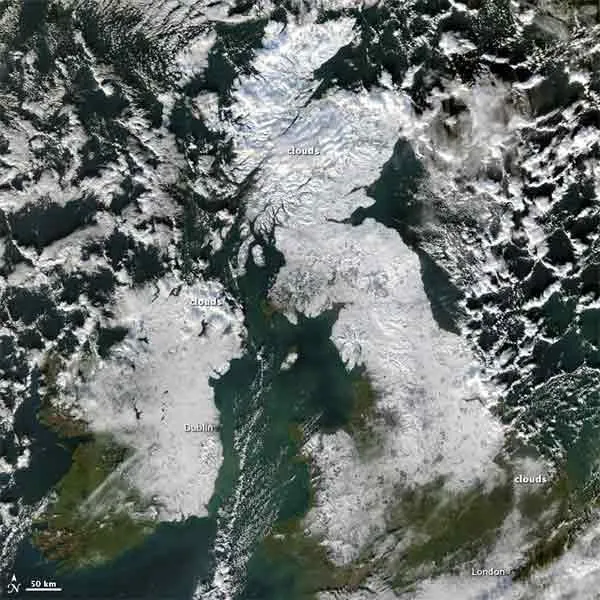
Snow lingered in Great Britain and Ireland on Dec. 8 from storms that buffeted northern Europe in recent weeks, shutting down airports, closing off roads and leading to many deaths from exposure to the elements.
In this image, taken by NASA's Aqua satellite, snow extends from Northern Ireland southward past Dublin, and from Scotland southward into England. Snow cover stops short of London; the white over the city is clouds, which are distinguishable from the underlying snow by their billowy shapes and indistinct margins.
Get the world’s most fascinating discoveries delivered straight to your inbox.
Rugged hills and gray-toned urban areas interrupt the snow cover, especially in northern England.
Christmas Blizzard of 2010
During the Christmas Blizzard of 2010, the East Coast was pummeled with snow and intense winds . In Wellfleet, Mass., wind speeds were clocked at 80 mph (128.7 kph). [Related: The Blow-by-Blow: Snowmageddon vs. Christmas Blizzard of 2010 .]
The Christmas Blizzard brought 20 inches (50.8 cm) of snow to Central Park, while Rahway, N.J. got the most snow during the storm, with 32 inches (81 cm).
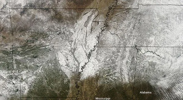
Southern Snow
The Moderate Resolution Imaging Spectroradiometer (MODIS) on NASA's Terra satellite caught this unusual view of snow across the southern United States on Jan. 12, 2011.
The swath of white follows the track of a winter storm that moved across the country between Jan. 9 and Jan. 11, according to a NASA statement. The rare snow led governors in Alabama, Georgia, Louisiana, North Carolina, South Carolina and Tennessee to declare emergencies, reported the Associated Press.
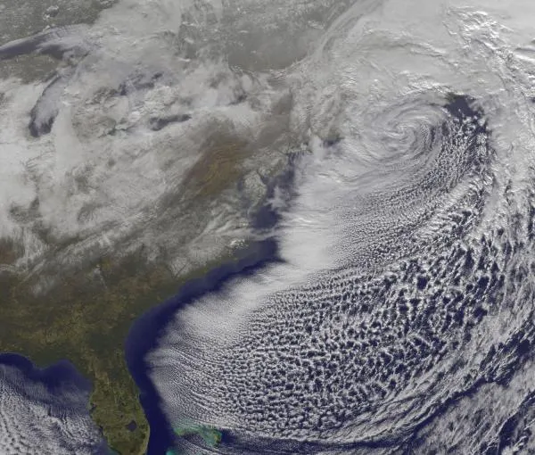
Classic Nor'easter
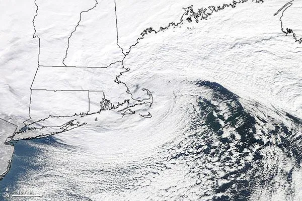
A classic Nor'easter plowed up the East Coast of the United States on Jan. 12, 2011, dumping heavy snow on New England states for the third time in three weeks, according to a NASA statement. The storm began developing late on Jan. 11, as a snow-making system that had hit the southern states rode up the Atlantic seaboard and merged with another system crossing from the Midwest.
The Moderate Resolution Imaging Spectroradiometer (MODIS) on NASA's Terra satellite took this photo-like image at 10 a.m. EST on Jan. 12, when the storm was centered over southern New England .
Snow-topped peaks
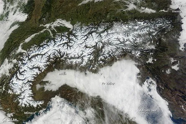
On Jan. 17, 2011, clear skies afforded NASA's Terra satellite an uninterrupted view of the Alps.
This natural-color image shows snow-capped mountains interspersed with vegetated valleys. Clouds snake through valleys in the north and west, and a nearly continuous cloud bank fills the Po Valley in the south, but skies over the mountains are clear.
The Alps form a crescent stretching from the Mediterranean coasts of Italy and France to Vienna, Austria.
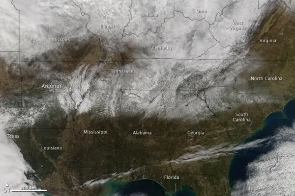
East Coast Snowstorm, Jan. 26
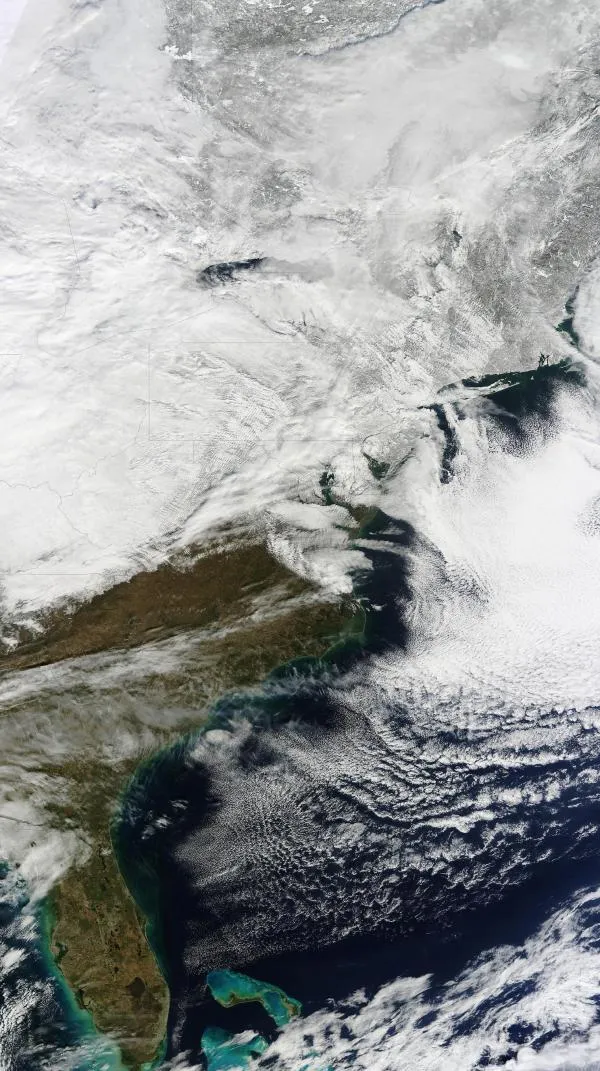
Heavy snows struck the Mid-Atlantic and northeastern United States again on Jan. 26 and 27.
The storm brought 19 inches (48.3 centimeters) of snow to New York City's Central Park, putting the winter's snowfall total for New York City at 56.5 inches (143.5 cm).
The 1995-96 winter is the Big Apple's snowiest of all time, with 76.5 inches (194.3 cm). Through Jan. 27, 1996, New York City had only seen 39.6 inches (100.6 cm) of snow.
Thundersnow
During the Jan. 26 snowstorm, thundersnow was heard rumbling in several places along the East Coast including Washington, Philadelphia and New York.
Thundersnow is a rarity, a wintertime thunderstorm with snow instead of rain. These storms spawn long, low rumbles of thunder, sometimes with lightning flashes. The lightning can stretch out in long creepy-crawly branches moving over tens of miles, similar to the lightning in squall line storms during Midwestern summers.
Siberia's Lake Baikal
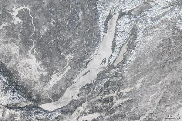
Ice covered Lake Baikal in late January 2011, as snow coated nearby peaks.
Ice on Lake Baikal is not at all unusual in January. The ice that forms on the lake is generally quite strong, even strong enough to support the weight of vehicles driving over the surface. Runners also rely on the ice to support their weight in the Lake Baikal International Ice Marathon.
Snow Covered Volcano
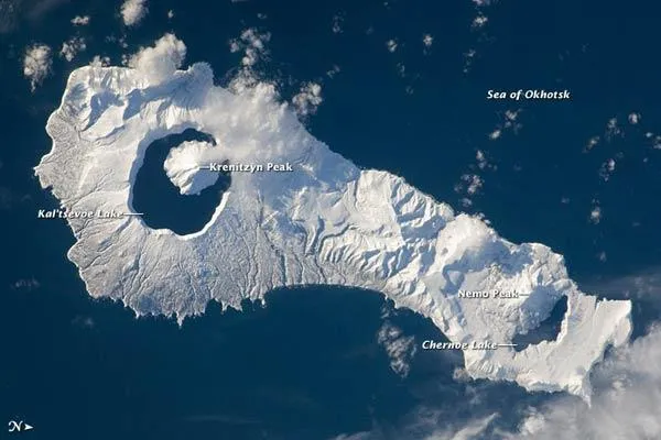
Snow cover highlights the calderas and volcanic cones that form the northern and southern ends of Onekotan Island, part of the Russian Federation in the western Pacific Ocean.
Calderas are depressions from when a volcano empties its magma chamber in an explosive eruption and then the overlaying material collapses into the evacuated space.
In this astronaut photograph from the International Space Station, the northern end of the island (image right) is dominated by the Nemo Peak volcano , which began forming within an older caldera approximately 9,500 years ago, according to a NASA statement. The last recorded eruption at Nemo Peak occurred in the early 18th century.
