Spring Flooding Under Way, and Worst 'Still Ahead'

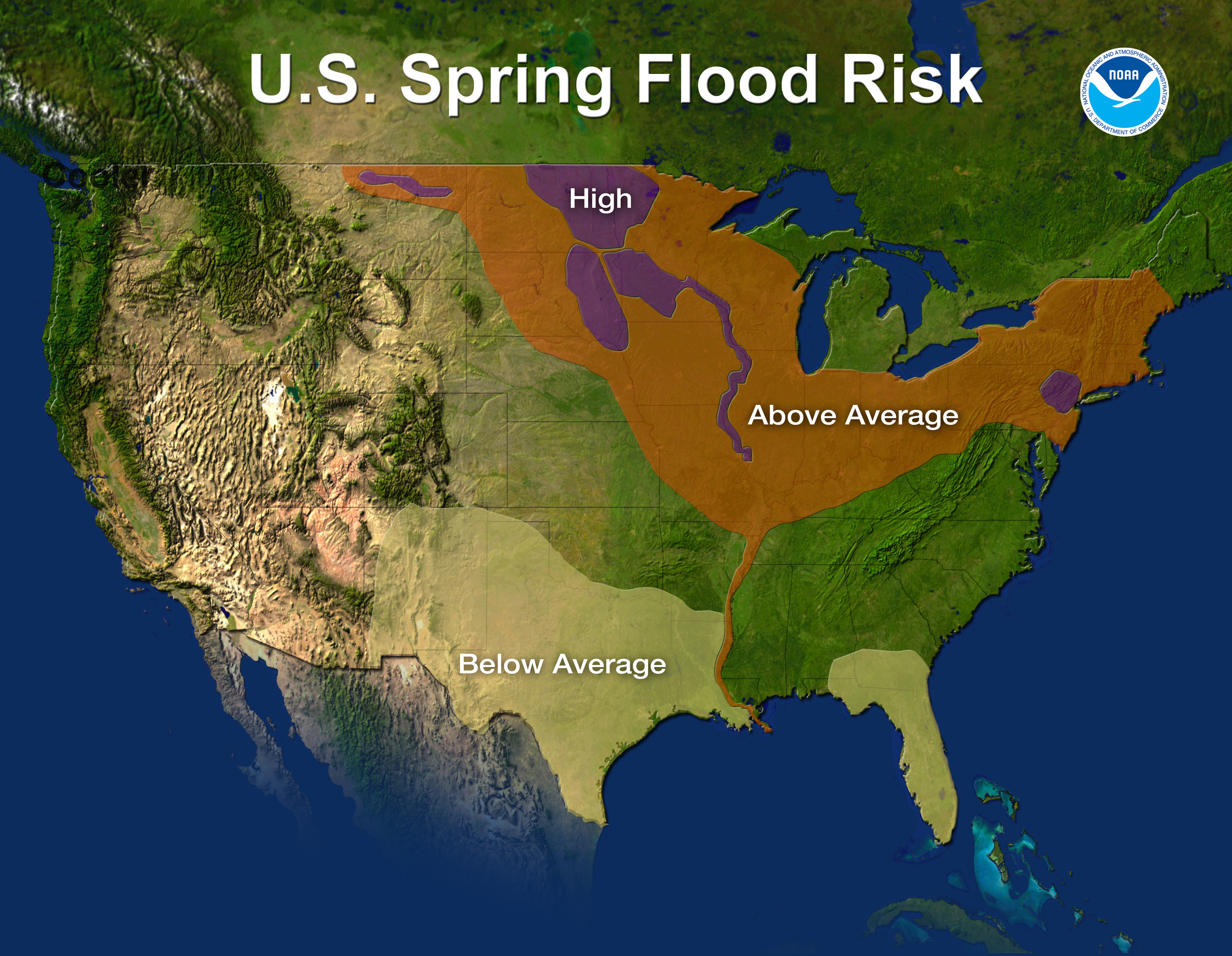
The official start of spring may be a few days away, but spring flooding has already begun. Almost half the country is at risk for above-average flooding this season, according to the National Weather Service's spring forecast, released today (March 17).
"Spring flooding has already begun in earnest in the United States, and the worst is still ahead," said Jack Hayes, the NWS director.
Spring is usually synonymous with tornado season, which begins in March and peaks from May to June. But because of this winter's brutal snowstorms and cold temperatures, the spring melt could add another threat, by overwhelming rivers across the country.
The water content in the soils of the north-central United States ranks among the highest of the last 60 years, according to the forecast, which covers the time from April to June. The regions with the highest risk of flooding are the north-central, Midwest and Northeast.
Already this year, people near the Passaic River in New Jersey are battling high waters. Next week, warmer temperatures could melt the snowpack across South Dakota and southern Minnesota and trigger major flooding in eastern South Dakota. Along the Mississippi River, forecasters are watching this week for minor flooding, with moderate to major flooding on the way in early April.
Rivers with the highest risk of flooding include:
- Red River: along the border of North Dakota and Montana
- Milk River: eastern Montana
- James and Big Sioux rivers: South Dakota
- Minnesota River
- Upper Mississippi River basin: from Minneapolis southward to St. Louis
Portions of lower New York, eastern Pennsylvania and northern New Jersey also have a high risk of flooding, the NWS said.
Get the world’s most fascinating discoveries delivered straight to your inbox.
The weather service predicts above-average temperatures in much of the southern half of the United States for the spring, and below-average temperatures from the Pacific Northwest to the northern plains.
The spring should be drier than average from South Florida to the Gulf Coast through Texas and into the Southwest. The northern plains should be wetter than average.
Wildfires will be a threat this spring, especially when humidity is low and winds are high, from the Southwest across the South and northward to the mid-Atlantic. Drought has been spreading in these regions since winter, and spring may see more of the same.
The spring forecast coincides with national Flood Safety Awareness Week. Flooding claims about 100 lives each year, making it the deadliest weather phenomenon, Hayes said. While tornadoes typically strike one section of the country, Tornado Alley, flooding is a more widespread threat.
"Of all the weather phenomena we deal with, floods are the one that people deal with throughout the country," said Craig Fugate, director of the Federal Emergency Management Agency.
The take-home message the NWS sends to those who are driving and encounter even shallow-looking water on the road: Turn around, don't drown.
Email OurAmazingPlanet staff writer Brett Israel at bisrael@techmedianetwork.com. Follow him on Twitter @btisrael.
