
 Live Science Plus


In Photos: Aftermath of Iceland Volcano Floods

A volcanic flood

In 2010, Iceland's Eyjafjallajökull volcano erupted, spewing a large plume of ash into the atmosphere, as well as melting part of the icecap on the volcano, sending meltwater gushing down and flooding the surrounding landscape.
Stuart Dunning, of Northumbria University in Newcastle upon Tyne in England, and his colleagues surveyed the landscape before and after the volcano's eruptions, to see how the floods impacted the area. Here are images from their trip. [Read the full story here]
Eyjafjallajökull

Iceland's Eyjafjallajökull volcano on July 17, 2010, after the main eruptions had ended.
Melt cauldron

A view into the main melt cauldron, Gígjökull crater, from the air. The melt water is steaming, which is why the smoke coming off the crater is white, not the much darker color it is when ash is being ejected, Dunning told LiveScience's OurAmazingPlanet. The water is held back by a crater dam of tephra and possibly ice.

Gouged gorge

Here, the Gigjokull proglacial lake is pictured a few weeks before the main eruption, "which caused floods to completely evacuate the water, and replace it with ice, ash and other eruptive materials," Dunning wrote in an email. Over the top center of the image is the future melt cauldron, while to the right-center, the gorge dug out by the water after it flowed over and/or through the glacier can be seen.
Post-eruption survey

Dunning and his colleague Andrew Large operating the Terrestrial Laser Scanner to capture a 3D map of the post-eruption landscape in front of Gigjokull Glacier. "The scanner captures tens of thousands of measurements of the location of whatever the laser beam bits every second, from 1 m to 2 km [3.3 feet to 1.2 miles] away," Dunning said.
Flooded valley
At glacier valley next door to Gigjokull Glacier and part of one of the big two floods that overtopped into the valley. "In the 1960's a large landslide fell onto the glacier and travelled through the proglacial lake, causing a large outburst flood. Telling the difference in the landform record between different triggers of outburst floods is challenging," Dunning wrote.
Closer look

Dunning and Large "taking a closer look into a trench through flood sediments we'd dug!" as Dunning put it.
Kettle hole
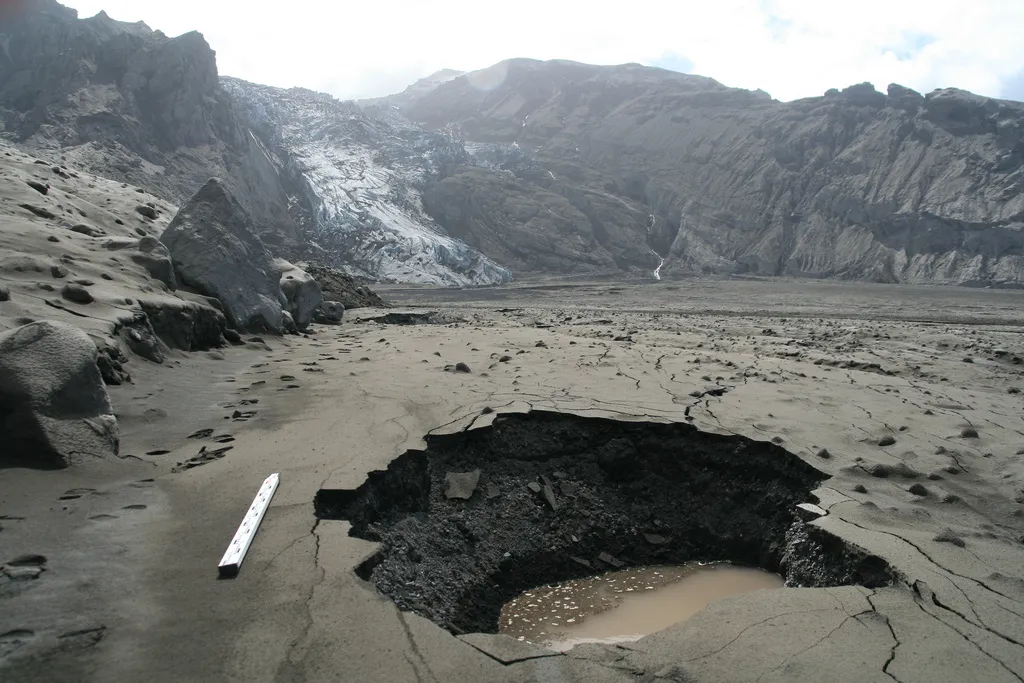
In the foreground of this view looking towards Gigjokull from what used to be the proglacial lake is a kettle hole. Dunning explains the phenomenon: "An ice block brought down during the flood has melted out leaving a hollow. Inside the walls of the hole you can see the alternating layers of fine and coarser flood sediments from one of the later, small outburst events."
3D Scan

One of the laser scans conducted by Dunning and his colleagues from Gigjokull glacier and basin beneath Eyjafjallajökull volcano. The colors of the scans correspond to different heights. [Read the full story here]
