It's quick and easy to access Live Science Plus, simply enter your email below. We'll send you a confirmation and sign you up for our daily newsletter, keeping you up to date with the latest science news.
Lighting flashed in the eye wall of Hurricane Erin as it intensified on Saturday (Aug. 15).
(Image credit: Cooperative Institute for Research in the Atmosphere at Colorado State University and the National Oceanic and Atmospheric Administration (CSU/CIRA & NOAA))
A weather satellite has captured stunning footage of Hurricane Erin crackling with flashes of lightning as it rapidly intensified into a Category 5 hurricane over the weekend.
The National Oceanic and Atmospheric Administration's (NOAA) latest geostationary satellite, GOES-19, recorded Erin as it strengthened into a hurricane on Friday (Aug. 15) and then topped the Saffir-Simpson Wind Scale with maximum sustained winds of 160 mph (260 km/h) on Saturday (Aug. 16).
Erin strengthened so quickly that it became one of the fastest intensifying storms in Atlantic history, CNN Weather reported. The tropical storm has varied in strength since becoming a Category 5, and is currently a Category 4, with maximum sustained wind speeds of about 130 mph (215 km/h).
Image 1 of 3
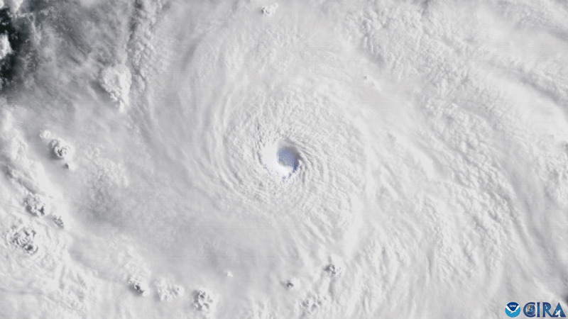
Erin became a hurricane on Friday (Aug. 15).(Image credit: Cooperative Institute for Research in the Atmosphere at Colorado State University and the National Oceanic and Atmospheric Administration (CSU/CIRA & NOAA))
Hurricane Erin rapidly intensified into a Category 5 hurricane on Saturday (Aug. 15).(Image credit: Cooperative Institute for Research in the Atmosphere at Colorado State University and the National Oceanic and Atmospheric Administration (CSU/CIRA & NOAA))
Lightning flashed around Hurricane Erin as the sun set on Saturday.(Image credit: Cooperative Institute for Research in the Atmosphere at Colorado State University and the National Oceanic and Atmospheric Administration (CSU/CIRA & NOAA))
While Erin isn't set to make landfall, it will likely threaten coastlines with life-threatening waves and flooding as it travels between the Bahamas and U.S. East Coast this week. A tropical storm warning is also currently in effect for the Turks and Caicos Islands and southeastern Bahamas, according to a National Hurricane Center (NHC) update.
The satellite images reveal stormy activity inside Erin, with lightning flashing around the eye of the storm like a bright blue iris.
The Geostationary Operational Environmental Satellites (GOES) are a network of satellites built by NASA and operated by NOAA. Researchers use the satellites for monitoring the weather on Earth and in space in real time.
Sign up for the Live Science daily newsletter now
Get the world’s most fascinating discoveries delivered straight to your inbox.
Erin developed into a named tropical storm on Aug. 11 with winds of about 45 mph (75 km/h) — the United Nations' World Meteorological Organization names tropical storms with maximum sustained wind speeds of more than 39 mph (63 km/h). By Aug. 15, Erin was strong enough to be classified as a hurricane, breaching the threshold of sustained wind speeds of 74 mph (119 km/h) or greater, and continued to strengthen until it peaked as a Category 5 hurricane on Saturday.
Patrick Pester is the trending news writer at Live Science. His work has appeared on other science websites, such as BBC Science Focus and Scientific American. Patrick retrained as a journalist after spending his early career working in zoos and wildlife conservation. He was awarded the Master's Excellence Scholarship to study at Cardiff University where he completed a master's degree in international journalism. He also has a second master's degree in biodiversity, evolution and conservation in action from Middlesex University London. When he isn't writing news, Patrick investigates the sale of human remains.
You must confirm your public display name before commenting
Please logout and then login again, you will then be prompted to enter your display name.

 Live Science Plus