


Hurricane Iota will slam into Nicaragua as a 'catastrophic' Category 5

Hurricane Iota, the 30th named storm this season, is expected to barrel into the Nicaraguan coast as a catastrophic Category 5 hurricane.
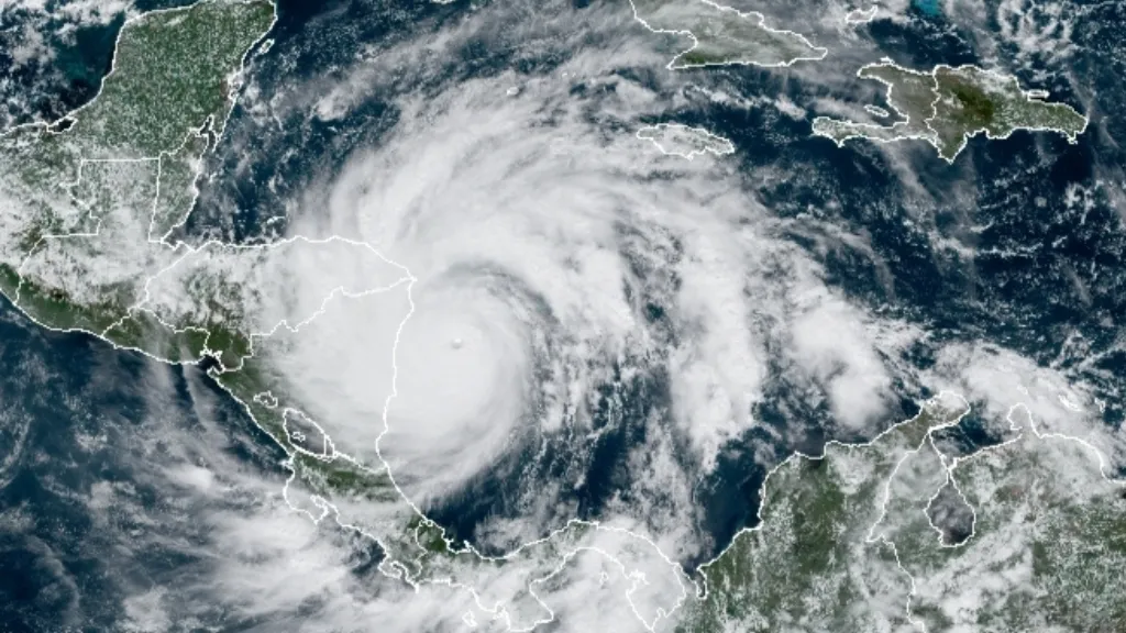
As of 10 a.m. Eastern time on Monday (Nov. 16), the center of the swirling storm sustained maximum winds of 160 mph (257 km/h), The Washington Post reported. The storm is projected to land near Puerto Cabezas on Monday night or Tuesday morning local time, touching down less than 15 miles (24 kilometers) from where Hurricane Eta struck the coast just two weeks ago. Iota ranks as the strongest hurricane ever observed this late in the season, according to the Post.
"Extreme winds and a life-threatening storm surge are expected along portions of the coast of northeastern Nicaragua, where a hurricane warning is in effect," according to a statement from the National Hurricane Center (NHC). Heavy rains are expected to continue through Thursday, Nov. 19, and will likely lead to flash flooding across portions of Central America.
The recent impacts of Hurricane Eta, which hit Nicaragua as a Category 4, may worsen flooding and mudslides caused by Iota, according to NPR. Neighboring Honduras sustained similar damage from Eta and may face "potentially catastrophic impacts" from Iota, as well, according to the NHC.
Related: A history of destruction: 8 great hurricanes
All told, Honduras, northern Nicaragua, southeast Guatemala and southern Belize could get between 10 and 20 inches (25 and 50 centimeters) of rain, NPR reported. Isolated areas may see up to 30 inches (76 centimeters) of rain, CBS News reported. Hurricane warnings have also been issued for Providencia Island, located east of Nicaragua in the Caribbean Sea, The Washington Post reported, and tropical storm or hurricane conditions are expected in San Andrés, an island south of Providencia, per the NHC statement.
During Eta, Nicaragua evacuated an estimated 30,000 people from their homes, and many never got the chance to return before Iota began hurtling across the Atlantic toward them, according to the Post. As of Sunday (Nov. 15), about 63,500 people had been evacuated in northern Honduras, according to NPR.
Get the world’s most fascinating discoveries delivered straight to your inbox.
Related Content
After Eta, the onslaught of wind, rain and flooding brought by Iota will only compound previous damage, according to the NHC statement.
"Eta arrived at the worst moment, making life more difficult for millions of people who have been affected for years by erratic climate and recently by the socioeconomic crisis caused by COVID-19," Miguel Barreto, a regional director of the World Food Program,the food-assistance branch of the United Nations, said in a statement Nov. 13, the Post reported. "It also worries us that rain and flooding could destroy the next harvest, which subsistence farmers depend on," he said.
On Sunday night (Nov. 15), Iota's winds speeds jumped by 40 mph (64 km/h) in just six hours; this is an example of "rapid intensification," where storms rapidly strengthen over a very short period of time. Scientists predict that rapid intensification will occur more and more frequently, as ocean temperatures continue to rise due to climate change.
Originally published on Live Science.

Nicoletta Lanese is the health channel editor at Live Science and was previously a news editor and staff writer at the site. She is a recipient of the 2026 AHCJ International Health Study Fellowship, with a project focused on antibiotic stewardship practices in Japan and the U.S. They hold a graduate certificate in science communication from UC Santa Cruz and degrees in neuroscience and dance from the University of Florida. Beyond Live Science, Lanese's work has appeared in The Scientist, Science News, the Mercury News, Mongabay and Stanford Medicine Magazine, among other outlets. Based in NYC, she also remains involved in dance and performs in local choreographers' work.