Live Science Plus


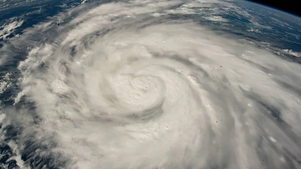
Hurricane Ian struck western Cuba Tuesday (Sept. 27) as a Category 3 storm and lost very little steam as it moved over the island and into the Gulf of Mexico, where the hurricane then ramped up to a Category 4 storm. The hurricane then continued to intensify as it barreled toward the west coast of Florida, nearly reaching Category 5 strength — the most powerful category for hurricanes — before making landfall near the barrier island of Cayo Costa.
Hurricanes typically lose strength as they move over land, so why didn't Ian rapidly weaken upon hitting Cuba? Several factors, including climate change, may have helped the storm gain and retain its power.
For starters, Ian passed through the extremely warm waters of the northwestern Caribbean Sea on its way to Cuba. There, the sea surface temperature is about 1.8 degrees Fahrenheit (1 degree Celsius) warmer than it has been in years past, in large part due to climate change, the Associated Press reported.
Article continues belowThe temperate water fueled Hurricane Ian's rapid growth, as did the region's low wind shear, meaning its lack of variation in wind speed or direction between the ocean's surface and the lower atmosphere, the National Hurricane Center (NHC) reported Monday (Sept. 26) evening. High wind shear can disrupt a growing hurricane's spiral structure and potentially tear the storm apart. Instead, the warm water and low wind shear allowed Ian to grow stronger and become better defined before reaching Cuba's shore.
Related: Hurricane season 2022: How long it lasts and what to expect
The then-Category 3 hurricane reached the island around 4:30 a.m. ET Tuesday with maximum sustained winds near 125 mph (201 km/h). At that time, the NHC reported that "Ian is expected to spend only a few hours over western Cuba, and little overall change in strength is likely during that time," since spending minimal time over land would help the storm retain its moisture and high wind speeds.
As predicted, the storm's center moved off Cuba's shore and entered the southeastern Gulf of Mexico by about 10 a.m. ET; there, the combination of warm water and low wind shear fueled the storm's intensification into a Category 4 hurricane.
Since the storm's formation, Ian has gone through several periods of "rapid intensification," meaning the hurricane's maximum sustained winds increased by at least 35 mph (56 km/h) in a 24-hour period. Research suggests that the proportion of North Atlantic hurricanes that undergo rapid intensification has been on the rise since the 1980s and that this increase may be linked to climate change, according to a 2019 report in the journal Nature Communications. That said, natural climate variations may account for some of the increase, according to NASA's Jet Propulsion Laboratory.
Another study, published in 2020 in the journal Nature, suggested that rising ocean temperatures may now allow hurricanes to move farther inland than they did 50 or 60 years ago. Scientists theorize that modern-day hurricanes pick up and hang on to moisture more effectively because of the oceans' unusual warmth and that this extra moisture slows the storms' decay over land. Now, hurricanes weaken by only about 50% within the first day of landfall, compared with 75% in the 1970s, the study authors reported.
However, it's difficult for experts to confirm if these broad trends factor into how Hurricane Ian formed and tore through the Atlantic this week. "It's really hard to say that climate change has an impact on any one storm in terms of its formation or its individual intensity," Kristen Corbosiero, a hurricane scientist at the University at Albany, told the Associated Press.
After entering the Gulf, Ian did encounter moderate wind shear and some patches of dry air before reaching the Florida coast, but due to its great size, the storm system was expected to be "fairly resilient" against these potential speed bumps, the NHC stated. The storm's magnitude and speed may even grant it enough juice to cross the entire Florida Peninsula.
"Ian is likely to remain more intact as it crosses the Florida peninsula (due to both its stronger initial wind speed and its faster forecast forward speed), and this now increases the threat of hurricane-force winds on the east coast of Florida," the NHC warned at 11 a.m. ET Wednesday (Sept. 28). "This necessitates the issuance of a Hurricane Warning on the east coast of central Florida."
Originally published on Live Science.