


Why Do Hurricanes Often Curve Out to Sea?
The forecast path of Hurricane Earl, expected to run parallel to the U.S. East Coast before heading offshore, is a typical one for Atlantic storms to follow.
The reason: They are steered away from land by prevailing wind patterns and surrounding environmental flow.
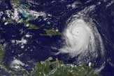
Hurricane Earl on Wednesday was downgraded from a category 4 to a 3 on the Saffir-Simpson scale with maximum sustained winds of 110 miles per hour (205 km per hour). The predicted path of Earl by the National Hurricane Center shows the storm's center likely to pass east of the Outer Banks and then east of Long Island.
Atlantic hurricanes can form anywhere from just off the west coast of Africa to somewhere near the Caribbean to inside the Gulf of Mexico. Those hurricanes that form out in the Atlantic tend to move westward, toward the United States, and then eventually turn north and often recurve back toward the east.
"Hurricanes are always going to try to curve northward," Dennis Feltgen, a spokesperson for the National Hurricane Center, said during a telephone interview. "A lot of them curve out to sea."
However, it is often difficult to know for certain whether a hurricane will head back out to sea, or when, or how sharp the recurvature will be, according to the National Oceanic and Atmospheric Administration (NOAA).
The direction that a tropical hurricane moves in is determined by the storm's surrounding environmental flow and the conditions throughout the depth of the troposphere, or the lower atmosphere located up to about 8 miles (12 km) in altitude.
Get the world’s most fascinating discoveries delivered straight to your inbox.
Seasonal weather patterns, strong winds, water currents and temperature also play a large role in directing a storm's path, according to NOAA. In fact, as storms shift north, they tend to weaken because they move over cooler water. (Hurricanes are fueled by warm water as it evaporates off the sea.)
In tropical latitudes, nearer the equator, prevailing wind patterns push storms toward the west, because of a high-pressure axis called the subtropical ridge, which extends east-west of the storms. Closer to the equator, general easterly winds prevail.
The wind pattern is driven partly by the Bermuda High, a high-pressure ridge that expands and contracts across the Atlantic during the summer months and is surrounded by a clockwise circulation. Many tropical storms will skirt around the Bermuda High, enhancing the pattern of moving west, then north. The exact path of a storm can depend greatly on how far north or south the Bermuda High is at that time. And since the high is a weak system (oftentimes due to a trough in the jet stream), tropical hurricanes can recurve back toward the east, according to NOAA.
In Earl's case, officials warn that the powerful hurricane may potentially swing by the North Carolina coastal region on Friday, before curving back out to sea. Tropical storm watches for the area could be issued as early as this afternoon or evening, according to The Weather Channel.
"There is still considerable uncertainty as to how close the hurricane will come to the U.S. East Coast," the U.S. National Hurricane Center in Miami said in a bulletin Tuesday.
Monday afternoon, Earl was located about 1,070 miles (1721 km) southeast of Cape Hatteras, North Carolina, moving west-northwest at 14 mph (22 kph). Once storms move north of Cape Hatteras, they tend to drastically accelerate due to the area's weather systems. A storm with a forward speed of 10 to 15 mph can accelerate to 20, 30, or even 50 mph in extreme cases.
Such extremes are rare, but a hurricane in 1938 raced from Cape Hatteras to Long Island in a matter of hours, at an average speed of 50 mph. In the morning of Sept. 21, it was off the coast of Hatteras, and by Noon it was tickling the New Jersey coast. By 5 p.m. it was in Massachusetts. Though the storm weakened, its forward speed was so great that it arrived in the Northeast before losing all its punch, creating 30-foot storm surges that swamped Providence, RI. It was in Canada by nightfall, having killed 600 people along the way.
This article was provided by Life's Little Mysteries, a sister site to LiveScience.