2 SoCal Earthquakes Warped the Ground for Miles. And It's Visible from Space.

Get the world’s most fascinating discoveries delivered straight to your inbox.
You are now subscribed
Your newsletter sign-up was successful
Want to add more newsletters?

Delivered Daily
Daily Newsletter
Sign up for the latest discoveries, groundbreaking research and fascinating breakthroughs that impact you and the wider world direct to your inbox.

Once a week
Life's Little Mysteries
Feed your curiosity with an exclusive mystery every week, solved with science and delivered direct to your inbox before it's seen anywhere else.

Once a week
How It Works
Sign up to our free science & technology newsletter for your weekly fix of fascinating articles, quick quizzes, amazing images, and more

Delivered daily
Space.com Newsletter
Breaking space news, the latest updates on rocket launches, skywatching events and more!

Once a month
Watch This Space
Sign up to our monthly entertainment newsletter to keep up with all our coverage of the latest sci-fi and space movies, tv shows, games and books.

Once a week
Night Sky This Week
Discover this week's must-see night sky events, moon phases, and stunning astrophotos. Sign up for our skywatching newsletter and explore the universe with us!
Join the club
Get full access to premium articles, exclusive features and a growing list of member rewards.
Two recent Southern California earthquakes warped the ground across dozens of square miles — and the changes are visible even from space.
A Japanese satellite picked up damage from the July 4 and 5 earthquakes that had magnitudes of 6.4 and 7.1, respectively. Quakes of these magnitudes are strong enough to cause moderate to severe damage to buildings.
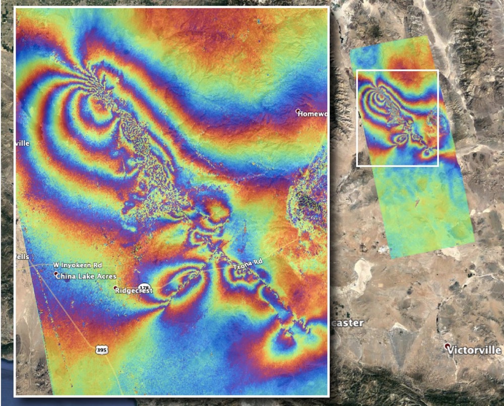
The July 5 earthquake was the strongest to hit the Ridgecrest region (150 miles, or 241 kilometers, northeast of Los Angeles) in 40 years, according to the U.S. Geological Survey. The surface displacement caused by this temblor and its predecessor is clear in new images from Japan's Advanced Land Observing Satellite (ALOS-2) satellite.
Related: Surface Rupture from Ridgecrest Earthquake Spotted from Space (Photo)
That satellite gathers data using a technique called synthetic aperture radar, which produces detailed measurements of the height of Earth's surface. Scientists at NASA's Jet Propulsion Laboratory (JPL), which is also located in Southern California, created a map based on the data.
Each color band represents 4.8 inches (12 centimeters) of ground displacement within the radar instrument's line of sight, JPL said in a statement. The most "noisy" areas, which appear the most muddled in the image, are likely where the ground was broken up by the earthquake. In the southeast corner of the image, linear features appear to slice through colored whirls and likely mark where the surface was sliced open by the quakes.
The USGS and the California Geological Survey, as well as other scientists, will use the map to assess damage and map the new faults. The region has also experienced 1,000 aftershocks that opened up a few cracks.
Get the world’s most fascinating discoveries delivered straight to your inbox.
Scientists are working closely with NASA's Earth Science Disasters Program (as well as many other partners that include the Federal Emergency Management Agency) to figure out how best to respond to the earthquake, JPL added.
The pair of earthquakes caused devastating damage to homes but no reported deaths or major injuries, according to news agencies.
- Climate Change Made Recent Hurricanes Wetter. And They May Get Worse.
- This Amazing Map Shows How California 'Breathes' Water Throughout the Year
- How Weather Satellites Changed the World
Follow Elizabeth Howell on Twitter @howellspace. Follow us on Twitter @Spacedotcom and on Facebook.

Elizabeth Howell was staff reporter at Space.com between 2022 and 2024 and a regular contributor to Live Science and Space.com between 2012 and 2022. Elizabeth's reporting includes multiple exclusives with the White House, speaking several times with the International Space Station, witnessing five human spaceflight launches on two continents, flying parabolic, working inside a spacesuit, and participating in a simulated Mars mission. Her latest book, "Why Am I Taller?" (ECW Press, 2022) is co-written with astronaut Dave Williams.
 Live Science Plus


