It's quick and easy to access Live Science Plus, simply enter your email below. We'll send you a confirmation and sign you up for our daily newsletter, keeping you up to date with the latest science news.
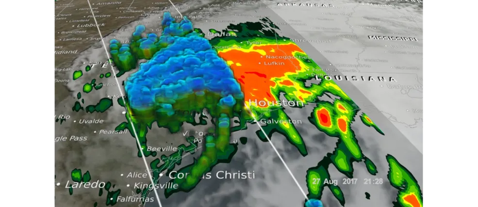
NASA's Global Precipitation Measurement (GPM) Core Observatory captured images of Harvey at 7:45 a.m. EDT (1145 GMT) and 5:25 p.m. EDT (2125 GMT) on Aug. 27, which was about two days after the storm system made landfall near Victoria, Texas. The image reveals rain rates depicted from GPM's GMI microwave imager and dual-frequency precipitation radar, which were overlaid on enhanced infrared data from NOAA's GOES East satellite.
(Image credit: NASA Scientific Visualization Studio)
NASA is aiding the humanitarian response to Tropical Storm Harvey by surveying the storm's impact from above. This effort will provide expert data to relief agencies.
Harvey first hit southeastern Texas on Aug. 25 as a Category 4 hurricane, and made landfall in southern Louisiana as a tropical storm on Aug. 30. The storm system lingered in the region, causing flooding and record-breaking rainfall. The downpour has been so immense that the National Hurricane Center called the flooding "life-threatening." NASA is assisting local, state and federal emergency managers and first responders by using its spacecraft to take measurements of the affected region, according to a new statement from the agency.
"This is an immense weather event that is creating a unique challenge," Thomas Zurbuchen, associate administrator for NASA's Science Mission Directorate at the agency's headquarters in Washington, D.C., said in the statement. "NASA is working to enable and enhance the capabilities of our partners across federal agencies and elsewhere to ensure [that] they are able to do the best job possible in assessing the threat and providing rescue and response services." [How to Donate to Harvey Victims Online]
NASA assigned its spacecraft to take measurements when the United States activated the humanitarian International Charter on Space and Major Disasters, NASA officials said in the statement. The space agency's leading entity for the humanitarian effort is the NASA Earth Science Disasters Program. This group's scientists and external partners will analyze satellite imagery and other data sets to inform effective disaster support for the state of Texas, the U.S. Geological Survey Hazards Data Distribution System, the Federal Emergency Management Agency (FEMA) and the National Guard.
NASA is obtaining high-resolution imagery of Earth's surface by analyzing data from synthetic aperture radar (SAR) instruments on international partner satellites, which are powerful enough to penetrate clouds night and day, according to the statement. NASA's Global Precipitation Measurement (GPM) mission team has also produced graphics that helped the National Oceanic and Atmospheric Administration's (NOAA's) National Hurricane Center better understand the center of Harvey's circulation.
The NASA-NOAA Suomi NPP satellite captured this nighttime image of the Gulf of Mexico, Texas and Louisiana on Aug. 29 at 3:03 a.m. Tropical Storm Harvey's center is identified over the Gulf.
(Image credit: William Straka III/NASA/NOAA/UWM-CIMSS)
Today (Aug. 31), NASA will fly the Uninhabited Aerial Vehicle Synthetic Aperture Radar (UAVSAR) instrument aboard a NASA Gulfstream III aircraft to observe rivers, floodplains and critical infrastructure. When the skies clear further over the area, the NASA Earth Science Disasters Program will use a number of Earth-observing satellites to map out flooding and power outages. These include the Moderate-Resolution Imaging Spectroradiometer (MODIS) instrument aboard NASA's Terra and Aqua satellites, the Advanced Spaceborne Thermal Emission and Reflection Radiometer (ASTER) aboard Terra, Landsat, and the Visible Infrared Imaging Radiometer Suite (VIIRS) aboard the Suomi-National Polar-orbiting Partnership (Suomi-NPP) satellite.

 Live Science Plus