


Facts About Microbursts
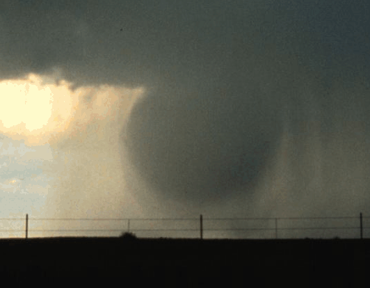
Microbursts, also called downbursts, are powerful, localized columns of wind that occur when cooled air drops from the base of a thunderstorm at incredible speeds — up to 60 mph — and subsequently hits the ground, spreading out in all directions.
Once this column of air reaches the ground (or body of water) and fans outward, it produces straight winds that can reach up to 100 mph, equivalent in speed to an EF1 tornado on the Enhanced Fujita scale, according to the National Oceanic and Atmospheric Administration (NOAA). Strong microbursts are capable of creating havoc for miles, knocking down trees, power lines and fences and causing extreme damage to buildings. Microbursts can occur all over the United States but are more common east of the Rocky Mountains, simply because there are more thunderstorms on this side.
What’s in a name?
The term “microburst” was coined by Ted Fujita, a severe storm researcher who developed the Fujita tornado intensity scale. It was upgraded to the Enhanced Fujita scale in 2007 and ranges from EF0 to EF5. An EF0 tornado may damage trees but not buildings, with winds ranging up to 85 mph (137 km/h). An EF5 tornado is devastating; winds exceed 200 mph (322 km/h), and buildings can be annihilated.

As the name suggests, a microburst is a relatively small weather event, lasting anywhere from a few seconds to several minutes and affecting 2.5 miles or less. For downbursts affecting areas greater than 2.5 miles, Fujita used the term “macroburst.”
How do microbursts form?
The most common weather event leading to microburst development is dry air entrainment, a phenomenon that occurs when dry air mixes with precipitation in a thundercloud. The dry air causes the droplets to evaporate, resulting in a rapid drop in air temperature. This patch of cooled air begins to sink, gaining momentum as it drops and essentially turning into a speeding column of air.
William Gallus, a professor of meteorology and numerical weather prediction in the department of geological and atmospheric sciences at Iowa State University, explains this phenomenon: “Cool air is heavier than warm air, so this blob of cold air can plunge toward the ground, and it spreads out rapidly when it hits the ground, kind of like how water explodes sideways when a water balloon is dropped and hits the ground,” he told Live Science.
When this cool, dry air is further pulled down by the weight of precipitation, it is called water loading, and this causes the air to drop even faster.
Get the world’s most fascinating discoveries delivered straight to your inbox.
Wet and dry microbursts
Microbursts are divided into two basic types: wet and dry. Depending on where you are in the country will determine which type you are more likely to encounter. Wet microbursts are more common in humid climates where there are plenty of thunderstorms, such as the Southeastern United States. These microbursts are typically driven by both dry air entrainment and water loading.
Dry microbursts usually begin with dry air entrainment due to moisture in the upper levels but eventually turn into wind-driven events with no surface precipitation. “For dry microbursts, we know they are more likely when the relative humidity a few thousand feet up in the sky is rather high, but it is much lower (dryer) below that level, especially near the ground. This kind of situation happens relatively often in places like Denver,” said Gallus. “When this happens, a storm can form from the moisture up high, but as it creates rain, the rain falls into the very dry air near the ground, and it evaporates, which cools the air.” Precipitation that evaporates before it hits the ground is called virga.
Some microbursts, known as hybrids, have characteristics of both wet and dry types and are driven by several influences, such as dry air entrainment, precipitation loading, cooling beneath the cloud base and/or sublimation (ice crystals turning directly into vapor), according to NOAA.
Microburst or tornado?
Though less well-known than tornadoes, microbursts are much more common. According to the National Weather Service, there are approximately 10 microburst reports for every one tornado, but these numbers are just an estimate.
“There has not been a detailed study done to look at how many happen on average each year in different areas, but it is believed a lot of wind damage happening in thunderstorms is likely due to microbursts, so that our climatology of wind damage from storms might give us a good idea [of their frequency],” Gallus said.
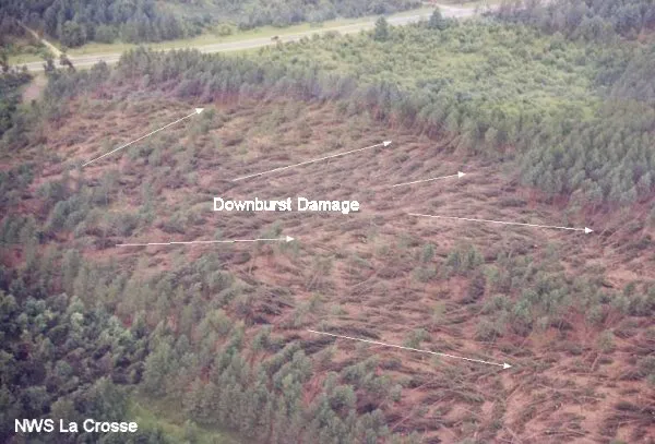
In fact, microbursts can cause so much damage that residents often believe they’ve been struck by a tornado. The surest way of knowing whether it was a tornado or a microburst, however, is by studying the pattern of damage. When a tornado hits, it leaves behind a more circular or meandering pattern of destruction and debris, while microburst winds cause straight-line damage that radiates from a center point of impact.
Disasters in the sky
The study of microbursts is relatively new in the field of atmospheric science. Before the introduction of Doppler radar at airports just a few decades ago, microbursts were responsible for as many as 20 major airline accidents, resulting in over 500 deaths, according to the National Science Foundation (NSF). Many of these had been mistakenly blamed on pilot error.
Microbursts still pose an incredible danger to aircraft, particularly during a take-off or landing. With winds up to 100 mph, trying to maneuver through a strong microburst is about as difficult as flying through a tornado. And like tornadoes, microburst development can be difficult to detect on radar and seem to come out of nowhere.
One terrible disaster in particular — the crash of Delta Airlines Flight 191 — is credited with speeding up microburst research as well as bringing stronger safety measures for all aircraft. The disaster happened in August 1985. A thunderstorm was hovering over Dallas/Fort Worth International Airport as the pilots of Flight 191 were preparing to land. As the aircraft descended toward the runway, an explosive downdraft of wind knocked the plane full of passengers to the ground, sending the aircraft careening onto a highway where it hit and killed an automobile driver and plowed into two large water tanks where it burst into flames. Only 27 people survived this horrific event, and 137 lives were lost.
While most pilots at this time had been highly trained in wind shear — rapid changes in wind speed or direction — surprisingly little was known about the specific dangers of microbursts. The crash of Delta 191 was a turning point, calling for more scientific research on these small but potentially fatal weather phenomena. Soon after, it was required that all planes be equipped with wind shear detection devices.
Thanks to better research and advancements in technology, including the introduction of Doppler radar in 1988, the airways are much safer today. The last U.S. commercial airline to crash from a microburst was USAir Flight 1016 in 1994.
Forecasting microbursts
Even with today’s advanced technology, detecting microbursts is still a difficult task. Not only are they a relatively small phenomenon, but they are also quick to form.
“It is very hard to predict microbursts,” Gallus said. “We can predict that an environment is somewhat favorable for microbursts, but we cannot tell in advance which exact locations will get hit by one, and not all storms will produce one even on a day when we say conditions are favorable. So it is a lot like forecasting tornadoes, except that conditions that support microbursts happen more often than those that support tornadoes.”
When forecasters are searching for ripe conditions, radar is the most helpful tool. They look for several factors, including air instability, high PW or precipitable water (a prediction of precipitation levels based on moisture in the atmosphere), dry air in middle levels, and strong winds in the layer of dry air, according to NOAA. The perfect conditions usually occur in the hot and humid summer months, especially in the Southeastern states.
An actual microburst in the works will give specific clues to the forecasters. “Radar can show air colliding a few thousand feet above the ground, which normally would mean some of the air is forced downward,” Gallus told Live Science. “Radar also can show air diverging or spreading out in the lowest part of the atmosphere, near the ground, which again is a sign that a microburst is happening.”
Radar does have some limitations when it comes to microbursts, though. For example, if a microburst forms on the outskirts of a radar’s reach, it may look so small that the meteorologist can’t see it, Gallus said. Also, since they form so quickly, one could hit the ground before a forecaster has time to issue a warning.
Another helpful tool for detecting microbursts is DCAPE (Downdraft Convective Available Potential Energy), a computation used to estimate the potential strength of downdrafts in thunderstorms. “DCAPE gives us an idea of how much negative buoyancy can happen, which means how much cooler can a blob of air get due to evaporative cooling than the background temperature,” Gallus said.
Additional resources
