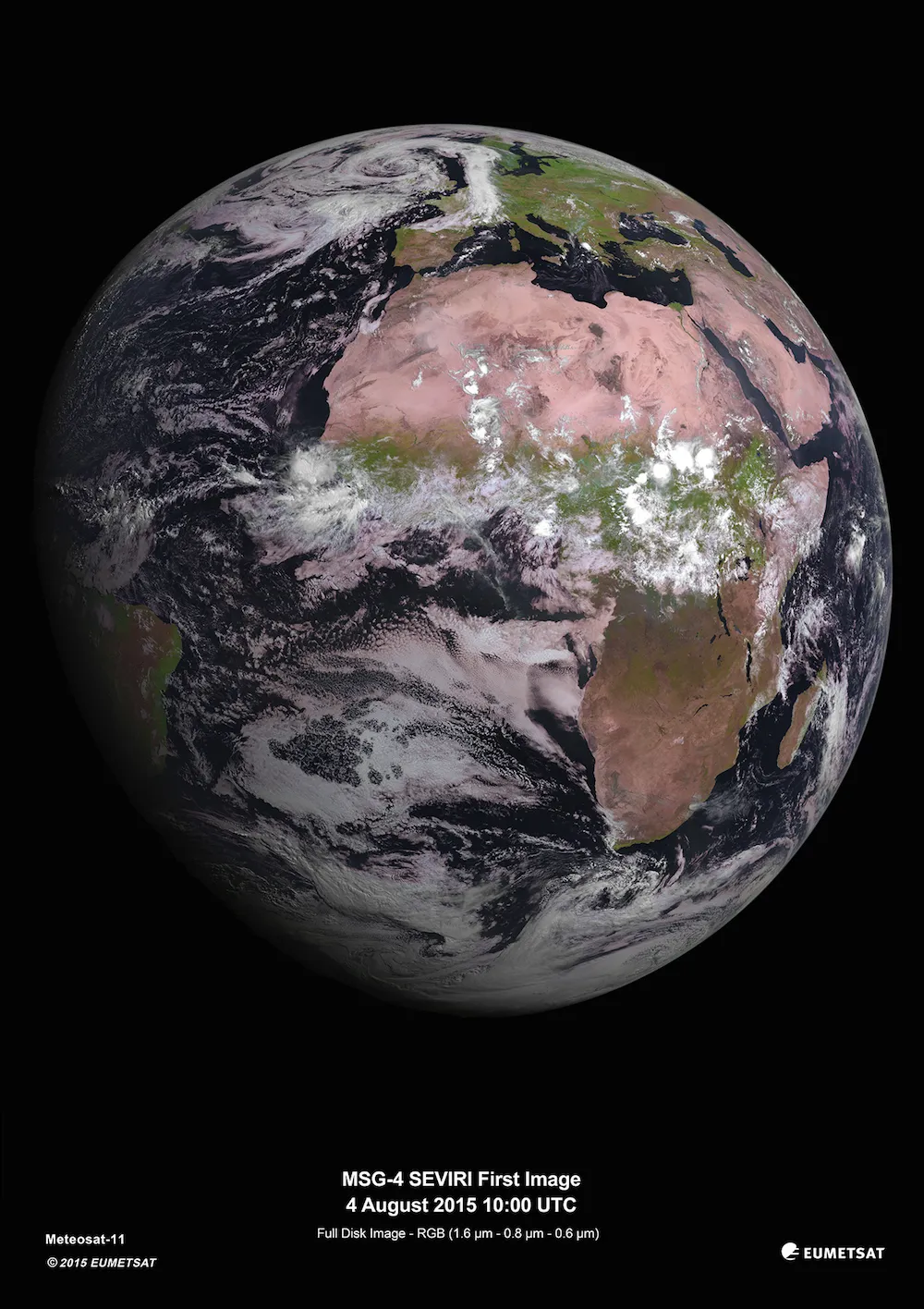
Africa looked awash in splotches of dusty pink, vibrant green and a swirl of white clouds in an image snapped Tuesday (Aug. 4) by Europe's newest weather satellite, according to an announcement from the European Space Agency (ESA).
The satellite, called Meteosat Second Generation 4 (MSG-4), is a space newbie that was launched into orbit on July 15 from French Guiana aboard an Ariane 5 rocket.
To orient MSG-4 in its spacious new home, the ESA moved the satellite into geostationary orbit (meaning MSG-4 rotates with Earth, but stays in the same spot relative to the ground below). Agency scientists also activated the satellite's SEVIRI (Spinning Enhanced Visible and Infrared Imager) scan mirror, which can take images in both infrared and visible wavelengths, according to a news release.
Latest Videos FromLive Science
After ESA scientists spent 11 days configuring the satellite, they handed its controls over to the European Organization for the Exploitation of Meteorological Satellites (EUMETSAT) on July 26. [Earth from Above: 101 Stunning Images from Orbit]
EUMETSAT researchers immediately got to work, and had the satellite take its first picture Tuesday using its SEVIRI imager. "This first image is a pseudo-true-color composite combining two visible images in different wavelengths with a very-near-infrared image," EUMETSAT spokesperson Valerie Barthmann told Live Science in an email. "It shows the clouds in mainly white and greyish colors, vegetated land in green, and dry and desert and arid areas in red/brown."
Barthmann pointed to the strong convective clouds over the equatorial region as a particularly striking part of the photograph. Such clouds form due to some instability in the atmosphere. Another standout feature is "the cloud formation over the British Isles related to a large low-pressure area pushing a band of heavy precipitation in over southern Scandinavia and Central Europe," she said.
In addition to providing Earthlings with a gorgeous view of home, the images indicate the imaging instrument on board MSG-4 is functioning as expected, Barthmann said. The satellite is expected to become fully operational in another six months, researchers said.
During the next two months, EUMETSAT researchers will do a satellite checkout and assessment, followed by four months of imaging and product testing, such as calibration and validation, according to a EUMETSAT statement. After the testing period, MSG-4 will be ready to help scientists on Earth analyze the weather, the researchers said.
The MSG-4 is the final satellite in the MSG series of geostationary satellites, according to EUMETSAT. The spacecraft will provide information every 15 minutes needed for "nowcasting" of high-impact events, such as big dust outbreaks in the Sahara Desert and volcanic eruptions; it will also record valuable data such as land surface temperatures and cloud height, the organization said.
Follow Laura Geggel on Twitter @LauraGeggel. Follow Live Science @livescience, Facebook & Google+. Original article on Live Science.