It's quick and easy to access Live Science Plus, simply enter your email below. We'll send you a confirmation and sign you up for our daily newsletter, keeping you up to date with the latest science news.
The entire U.S. Northeast is under blizzard and winter storm warnings from the National Weather Service today (Jan. 26). Millions of people could wake up tomorrow to more than 2 feet (some 60 centimeters) of snow from what could be the worst East Coast winter storm in a decade. Whiteout conditions and fierce winds are expected tonight and tomorrow from Connecticut to Maine. The governor of Connecticut has banned travel after 9 o'clock tonight and New York City's mayor banned non-emergency vehicles on roads after 11 p.m.
As the storm bears down on the Northeast, here are five stunning weather maps that highlight its massive impact.
Nearly 30 million people are currently under blizzard warnings, which stretch along the coastal areas from New Jersey to Maine, with another 12 million people farther inland under winter storm warnings. (Photo credit: NOAA/NWS)
Historic snowfall?
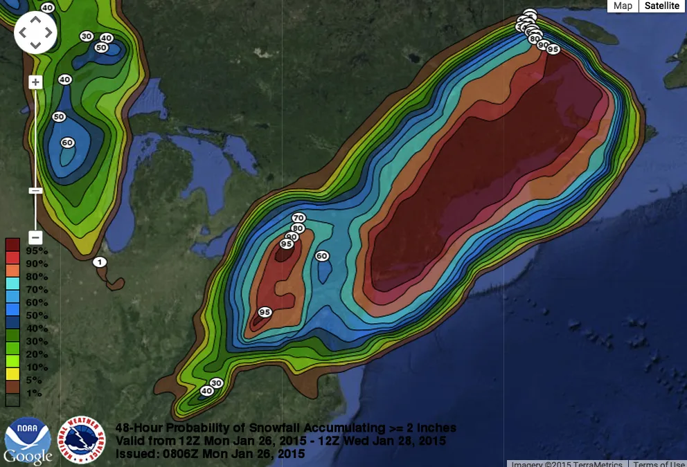
There is a 100 percent chance most areas of eastern Massachusetts will be muffled under at least a foot of snow (30.5 cm) following the storm, according to the National Weather Service in Boston. New York, Long Island and southern Connecticut also have an 80 to 90 percent chance of seeing at least 12 inches of snow, the National Weather Service (NWS) in New York said. (Photo credit: NWS Boston) [Worst Northeast Snowstorms: How Does 'Juno' Compare? ]
Watch out, don't wipe out
Sign up for the Live Science daily newsletter now
Get the world’s most fascinating discoveries delivered straight to your inbox.
The high snowfall and strong winds will lead 6 to 8 solid hours of blizzard conditions, according to this forecast model from Greg Carbin, the warning coordination meteorologist at the NWS Storm Prediction Center. The blizzard conditions are in light blue. Power outages are likely with wind gusts expected to reach at least 50 mph (80 km/h). (Photo credit: @GCarbin/NWS/NOAA)
Snowy wave
The storm's emerging winds created a stunning vortex just off the mid-Atlantic coast this afternoon, as seen in this image from earth.nullschool.net.
Storm takes aim
A weather satellite snapped this image of the storm looming over the East Coast this morning.
Becky Oskin covers Earth science, climate change and space, as well as general science topics. Becky was a science reporter at Live Science and The Pasadena Star-News; she has freelanced for New Scientist and the American Institute of Physics. She earned a master's degree in geology from Caltech, a bachelor's degree from Washington State University, and a graduate certificate in science writing from the University of California, Santa Cruz.