


Deadly Tornado's Track Seen from Space (Photo)
A new satellite image reveals the damage wrought by an EF4 tornado as it tore through Arkansas on April 27.
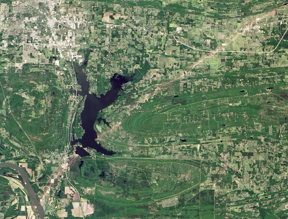
The tornado track runs from the upper right to the lower left of the image, traveling through the towns of Mayflower and Vilonia, Arkansas. This image, released yesterday (May 6), was taken on May 2 by NASA's Advanced Land Imager on the Earth-Observing-1 satellite, according to NASA's Earth Observatory.
The storm that spawned this tornado came from a system that moved in from the Rocky Mountains, pushing a cold front with it, according to the National Weather Service office in Little Rock, Arkansas. The interaction of cold air with moist, warm air created the perfect breeding ground for thunderstorms, and the NWS warned that tornadoes and hail were possible. [Video: Deadly Tornado Outbreak Seen from Space]
A tornado is born
One storm northwest of Little Rock turned into a supercell storm. In a supercell, a cold front forces warm, moist air to rise. But as this moist air cools and condenses, it creates a downdraft of cold air. When warm updrafts are balanced by cool downdrafts, the storm can churn along for hours — and form tornadoes.
At around 7 p.m. local time on April 27, the supercell northwest of Little Rock did just that. The resulting twister had winds of between 166 and 200 miles per hour (267 to 322 km/h). The estimated wind speeds and high levels of damage gave the tornado a rating of EF4 on the Enhanced Fujita (EF) tornado scale.
The tornado traveled northeast more than 41 miles (66 km) and remained on the ground for an hour. Hundreds of homes were destroyed, some swept entirely from their foundations. Sixteen people died in the tornado, including an Iraq war veteran who died shielding his 5-year-old daughter from a falling beam when their home was destroyed and 7- and 8-year-old brothers whose parents were seriously injured.
Get the world’s most fascinating discoveries delivered straight to your inbox.
The tornado was the deadliest in Arkansas since 1968, according to the NWS.
Weather damage
The Mayflower-Vilonia tornado was not the only twister spawned by the April 27 storm. Another tornado hit Quapaw, Oklahoma, that evening, killing one person before crossing the state line into Baxter Springs, Kansas. Another tornado hit in Tennessee not far from the Alabama state line.
Floods also affected many areas in Arkansas, Missouri, Alabama and Florida as a result of the storm. As the system moved east, it brought moisture to the mid-Atlantic and Northeast, causing localized flooding in Virginia, Maryland and Delaware.
Follow Stephanie Pappas on Twitter and Google+. Follow us @livescience, Facebook & Google+. Original article on Live Science.

Stephanie Pappas is a contributing writer for Live Science, covering topics ranging from geoscience to archaeology to the human brain and behavior. She was previously a senior writer for Live Science but is now a freelancer based in Denver, Colorado, and regularly contributes to Scientific American and The Monitor, the monthly magazine of the American Psychological Association. Stephanie received a bachelor's degree in psychology from the University of South Carolina and a graduate certificate in science communication from the University of California, Santa Cruz.