


Satellite Spies Winter Storm as Eastern US Digs Out (Photo)
The massive storm system bringing miserable weather to the eastern United States can be seen blanketing the region in pictures from space.
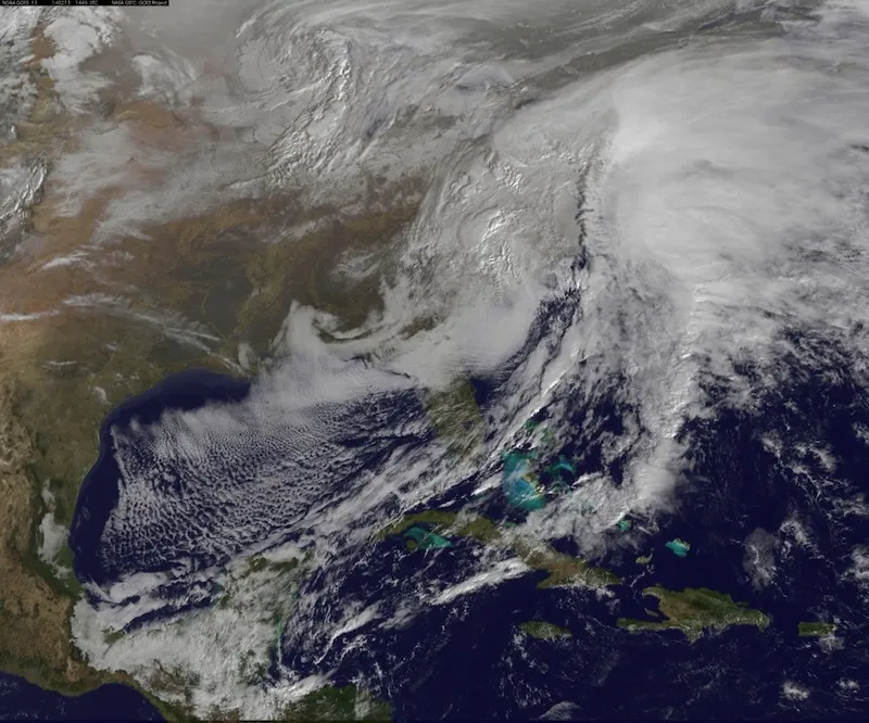
NOAA's GOES-13 satellite captured this storm image of the Eastern Seaboard on Thursday morning (Feb. 13) 9:45 a.m. EST (1455 UTC), as residents from Georgia to Boston awoke to sleet, ice and several inches snow.
Not all of the white patches covering the eastern half of the United States are clouds; some of the frosty areas in the picture are actually snow-covered ground in the Great Lakes region and Ohio Valley, according to NASA. [Snow Day: See Images of the East Coast Storm]
NASA/NOAA's GOES Project at the space agency's Goddard Space Flight Center in Greenbelt, Md., created the picture, which also incorporates true-color land and ocean image data from the Moderate Resolution Imaging Spectroradiometer or MODIS instrument aboard NASA's Earth-watching sister satellites, Aqua and Terra.
GOES satellites are geostationary, which means they hover over the same position on Earth all the time, orbiting in tandem with the planet's rotation. The spacecraft take pictures of clouds that are used by NOAA's National Weather Service to monitor storms.
By the time this picture was taken, the winter storm had already pounded the South and much of the Mid-Atlantic, causing school closures, flight cancellations, mass power outages and traffic jams. The storm has been blamed for at least 17 deaths, most of them in traffic accidents, according to the Associated Press. Parts of northern Georgia saw over 9 inches (22 centimeters) of snow, while up to 18 inches (45 cm) of the white stuff covered some areas of Virginia, Maryland and Pennsylvania.
The storm is expected to keep heaping bad weather on the Northeast through Friday in the form of more snow, sleet and freezing rain.
Get the world’s most fascinating discoveries delivered straight to your inbox.
An update from the National Weather Service at 10:00 a.m. EST read: "An abundance of Atlantic moisture getting wrapped into the storm will continue to fuel widespread precipitation ... which should lift through the Mid-Atlantic States and Northeast Thursday into Friday. A wide swath of heavy snow accumulations are expected with this storm ... but air [moving] off the warmer ocean water should change snow over to rain along the coastal areas. Also ... a narrow axis of sleet and freezing rain will be possible within the transition zone ... which is expected to set up near the I-95 corridor."
Follow Megan Gannon on Twitter and Google+. Follow us @livescience, Facebook & Google+. Original article on Live Science.
